Property Record
3915 Beryl Rd, Raleigh, NC 27607
Current Lease Availabilities
NEARBY LISTINGS FOR SALE OR LEASE
Property Detail
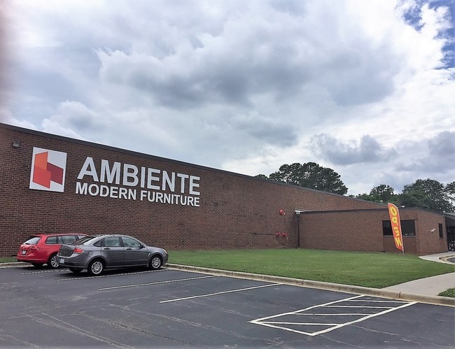
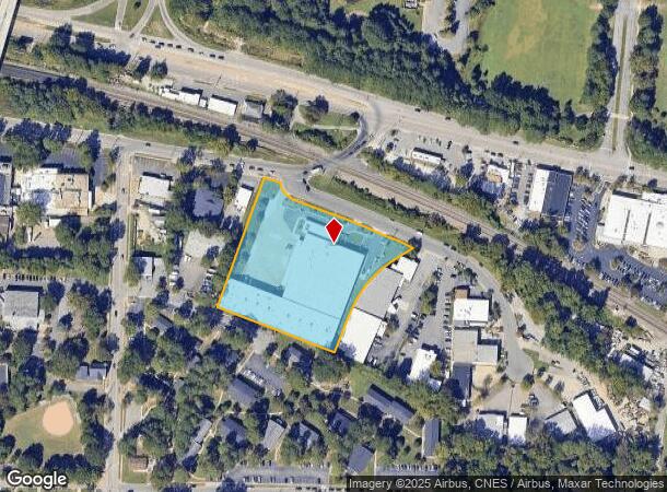
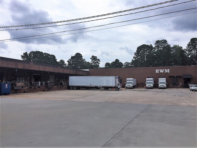
3915 Beryl Rd
0794.13-13-3879-000
Property/Michael & Raquel Sehe
Warehouse
BERRY OKELLY LAND
X
Wake
3720079400K
North Carolina
2025
3.38 AC
2025
West Raleigh
051101
Raleigh/Durham
71,389 SF
Raleigh-Cary, NC
DEMOGRAPHICS near 3915 Beryl Rd
1 Mile
3 Mile
5 Mile
2024 Total Population
10,380
97,924
228,087
2029 Population
11,352
106,735
248,507
Pop Growth 2024-2029
+ 9.36%
+ 9.00%
+ 8.95%
Average Age
30
35
37
2024 Total Households
3,803
43,164
100,552
HH Growth 2024-2029
+ 10.57%
+ 9.62%
+ 9.35%
Median Household Inc
$33,420
$67,122
$73,890
Avg Household Size
2.10
2.00
2.10
2024 Avg HH Vehicles
2.00
2.00
2.00
Median Home Value
$571,801
$557,660
$440,961
Median Year Built
1984
1989
1990
Nearby Places
Map Layers
Map Styles
 Street
 Aerial
- Restaurants
- Banks
- Shops
- Fitness
- Groceries
PUBLIC TRANSPORTATION
COMMUTER RAIL
Raleigh Union Station (Piedmont - North Carolina by Train (NC Train))
DRIVE
WALK
Distance
Raleigh Union Station (Piedmont - North Carolina by Train (NC Train))
7 min
3.0 mi
Cary Station (Piedmont - North Carolina by Train (NC Train))
DRIVE
WALK
Distance
Cary Station (Piedmont - North Carolina by Train (NC Train))
11 min
5.9 mi
AIRPORT
Raleigh-Durham International
DRIVE
WALK
Distance
Raleigh-Durham International
16 min
10.3 mi
Freight Ports
Port of Wilmington
DRIVE
WALK
Distance
Port of Wilmington
159 min
136.9 mi
Nearby Properties
Address
Land Use
TOTAL SIZE
Lot Size
Zoning
Address
Land Use
TOTAL SIZE
Lot Size
Zoning
5,616,802 SF
507.97 AC
OX-12
Address
Land Use
TOTAL SIZE
Lot Size
Zoning
1,109,877 SF
746.53 AC
CMP
Address
Land Use
TOTAL SIZE
Lot Size
Zoning
1,801,169 SF
59.60 AC
OX-12
Address
Land Use
TOTAL SIZE
Lot Size
Zoning
770,311 SF
80.70 AC
PD
Address
Land Use
TOTAL SIZE
Lot Size
Zoning
854,180 SF
210.81 AC
OX-4
Address
Land Use
TOTAL SIZE
Lot Size
Zoning
294,812 SF
999.47 AC
AP
Address
Land Use
TOTAL SIZE
Lot Size
Zoning
613,087 SF
266.85 AC
PD
Address
Land Use
TOTAL SIZE
Lot Size
Zoning
1,810,132 SF
OX-12
Address
Land Use
TOTAL SIZE
Lot Size
Zoning
706,810 SF
40.78 AC
IH
Address
Land Use
TOTAL SIZE
Lot Size
Zoning
12,850 SF
96.80 AC
OX-12
Address
Land Use
TOTAL SIZE
Lot Size
Zoning
675,817 SF
3.56 AC
DX-12
Address
Land Use
TOTAL SIZE
Lot Size
Zoning
372,222 SF
9.64 AC
DX-12
Address
Land Use
TOTAL SIZE
Lot Size
Zoning
403,230 SF
197.34 AC
IX-3
Address
Land Use
TOTAL SIZE
Lot Size
Zoning
250,448 SF
25.28 AC
OX-3
Address
Land Use
TOTAL SIZE
Lot Size
Zoning
982,323 SF
154.02 AC
OX-7
Address
Land Use
TOTAL SIZE
Lot Size
Zoning
1,039,527 SF
22.85 AC
OX-7
Address
Land Use
TOTAL SIZE
Lot Size
Zoning
524,391 SF
4.13 AC
NX-5
Address
Land Use
TOTAL SIZE
Lot Size
Zoning
462,217 SF
1.01 AC
DX-20
Address
Land Use
TOTAL SIZE
Lot Size
Zoning
834,950 SF
3.91 AC
OX-12
Address
Land Use
TOTAL SIZE
Lot Size
Zoning
561,966 SF
3.81 AC
IX-7
Address
Land Use
TOTAL SIZE
Lot Size
Zoning
426,539 SF
2.90 AC
NX-5
Address
Land Use
TOTAL SIZE
Lot Size
Zoning
613,248 SF
2.20 AC
IND-2
Address
Land Use
TOTAL SIZE
Lot Size
Zoning
580,268 SF
9.02 AC
PD
Address
Land Use
TOTAL SIZE
Lot Size
Zoning
931,884 SF
10.21 AC
CMP
Address
Land Use
TOTAL SIZE
Lot Size
Zoning
378,159 SF
22.40 AC
OX-7
Address
Land Use
TOTAL SIZE
Lot Size
Zoning
201,558 SF
4.05 AC
DX-12
Address
Land Use
TOTAL SIZE
Lot Size
Zoning
495,697 SF
9.11 AC
OX-5
Address
Land Use
TOTAL SIZE
Lot Size
Zoning
483,677 SF
1.13 AC
DX-20
Address
Land Use
TOTAL SIZE
Lot Size
Zoning
420,188 SF
2.14 AC
DX-7
Address
Land Use
TOTAL SIZE
Lot Size
Zoning
395,263 SF
6.07 AC
CX-5
The World's #1 Commercial Real Estate Marketplace
Connect with us
© 2026 CoStar Group
The information above has been obtained from sources believed reliable. While we do not doubt its accuracy we have not verified it and make no guarantee, warranty or representation about it. It is your responsibility to independently confirm its accuracy and completeness. Any projections, opinions, assumptions, or estimates used are for example only and do not represent the current or future performance of the property. The value of this transaction to you depends on tax and other factors which should be evaluated by your tax, financial, and legal advisors. You and your advisors should conduct a careful, independent investigation of the property to determine to your satisfaction the suitability of the property for your needs.