Property Record
3915 Dundrum Dr, Dublin, OH 43016


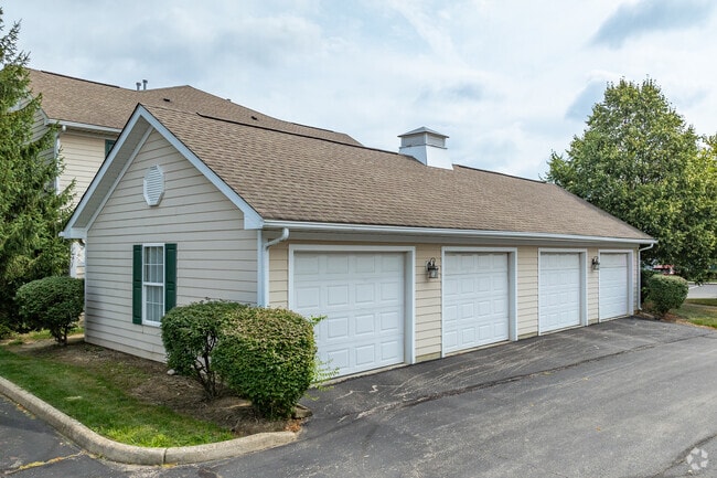
Property Detail
3915 Dundrum Dr
273-011301
HARD RD R19 T2 1/4T2 27.465 ACRES
Apartment
FRANKLIN
B and X Area of moderate flood hazard, usually the area between the limits of the 100-year and 500-year floods.
Ohio
2024
27.47 AC
2025
Outer Dublin/Hilliard
006398
Columbus
151,623 SF
Columbus, OH
NEARBY LISTINGS FOR SALE OR LEASE
-
-
View all Dublin listings for sale on LoopNet.com
DEMOGRAPHICS near 3915 Dundrum Dr
1 mile
3 mile
5 mile
2025 Total Population
9,952
82,759
211,032
2030 Population
10,145
85,247
219,536
Pop Growth 2025-2030
+ 1.94%
+ 3.01%
+ 4.03%
Average Age
37
39
39
2025 Total Households
4,033
32,401
84,777
HH Growth 2025-2030
+ 2.11%
+ 3.26%
+ 3.97%
Median Household Inc
$92,215
$114,551
$110,114
Avg Household Size
2.40
2.50
2.40
2025 Avg HH Vehicles
2.00
2.00
2.00
Median Home Value
$417,201
$436,187
$452,441
Median Year Built
1987
1988
1990
Nearby Places
Map Layers
Map Styles
 Street
 Aerial
Layers
 Traffic
 Biking
Places
Listings with unknown addresses are not visible on the map
- Restaurants
- Banks
- Shops
- Fitness
- Groceries
PUBLIC TRANSPORTATION
AIRPORT
John Glenn Columbus International
Drive
Walk
Distance
John Glenn Columbus International
27 min
19.8 mi
Rickenbacker International
Drive
Walk
Distance
Rickenbacker International
39 min
30.7 mi
Freight Ports
Port of Toledo
Drive
Walk
Distance
Port of Toledo
169 min
133.7 mi
Nearby Properties
Address
Land Use
TOTAL SIZE
Lot Size
Zoning
Address
Land Use
TOTAL SIZE
Lot Size
Zoning
90.16 AC
Address
Land Use
TOTAL SIZE
Lot Size
Zoning
297,024 SF
71.76 AC
Address
Land Use
TOTAL SIZE
Lot Size
Zoning
557,021 SF
21.28 AC
Address
Land Use
TOTAL SIZE
Lot Size
Zoning
232,579 SF
54.30 AC
Address
Land Use
TOTAL SIZE
Lot Size
Zoning
173,618 SF
1.13 AC
Address
Land Use
TOTAL SIZE
Lot Size
Zoning
223,270 SF
1.30 AC
Address
Land Use
TOTAL SIZE
Lot Size
Zoning
261,872 SF
53.89 AC
Address
Land Use
TOTAL SIZE
Lot Size
Zoning
200,609 SF
21.87 AC
Address
Land Use
TOTAL SIZE
Lot Size
Zoning
178,568 SF
31.62 AC
Address
Land Use
TOTAL SIZE
Lot Size
Zoning
95,447 SF
58.80 AC
Address
Land Use
TOTAL SIZE
Lot Size
Zoning
160,958 SF
11.93 AC
Address
Land Use
TOTAL SIZE
Lot Size
Zoning
115,032 SF
12.81 AC
Address
Land Use
TOTAL SIZE
Lot Size
Zoning
129,283 SF
56.69 AC
Address
Land Use
TOTAL SIZE
Lot Size
Zoning
42,494 SF
0.19 AC
Address
Land Use
TOTAL SIZE
Lot Size
Zoning
414,372 SF
24.87 AC
Address
Land Use
TOTAL SIZE
Lot Size
Zoning
184,139 SF
20.57 AC
Address
Land Use
TOTAL SIZE
Lot Size
Zoning
257,993 SF
9.98 AC
Address
Land Use
TOTAL SIZE
Lot Size
Zoning
245,705 SF
6.50 AC
Address
Land Use
TOTAL SIZE
Lot Size
Zoning
323,955 SF
31.18 AC
Address
Land Use
TOTAL SIZE
Lot Size
Zoning
216,100 SF
28.17 AC
Address
Land Use
TOTAL SIZE
Lot Size
Zoning
168,323 SF
22.61 AC
Address
Land Use
TOTAL SIZE
Lot Size
Zoning
111,376 SF
0.55 AC
Address
Land Use
TOTAL SIZE
Lot Size
Zoning
122,663 SF
0.60 AC
Address
Land Use
TOTAL SIZE
Lot Size
Zoning
123,149 SF
12.09 AC
Address
Land Use
TOTAL SIZE
Lot Size
Zoning
86,934 SF
8.80 AC
Address
Land Use
TOTAL SIZE
Lot Size
Zoning
365,841 SF
30.07 AC
Address
Land Use
TOTAL SIZE
Lot Size
Zoning
303,819 SF
54.15 AC
Address
Land Use
TOTAL SIZE
Lot Size
Zoning
57,864 SF
5.76 AC
Address
Land Use
TOTAL SIZE
Lot Size
Zoning
159,901 SF
19.97 AC
Address
Land Use
TOTAL SIZE
Lot Size
Zoning
131,905 SF
6.32 AC
The World's #1 Commercial Real Estate Marketplace
Connect with us
© 2026 CoStar Group
The information above has been obtained from sources believed reliable. While we do not doubt its accuracy we have not verified it and make no guarantee, warranty or representation about it. It is your responsibility to independently confirm its accuracy and completeness. Any projections, opinions, assumptions, or estimates used are for example only and do not represent the current or future performance of the property. The value of this transaction to you depends on tax and other factors which should be evaluated by your tax, financial, and legal advisors. You and your advisors should conduct a careful, independent investigation of the property to determine to your satisfaction the suitability of the property for your needs.