Property Record
3915 N Rocky River Rd, Monroe, NC 28110
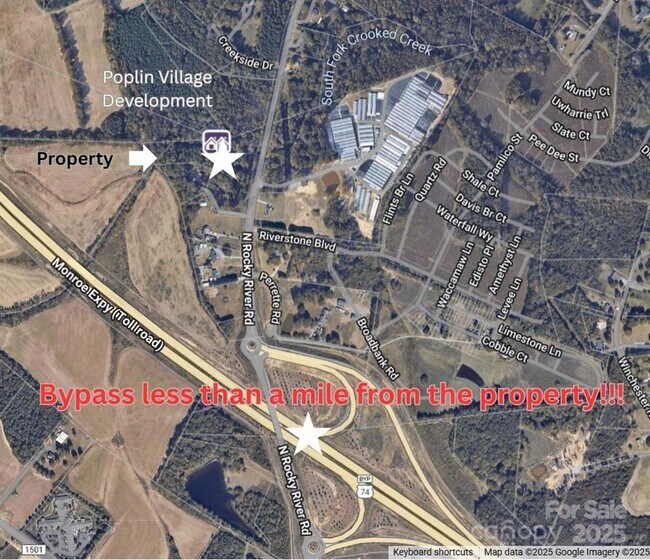

This Property Is For Sale
NEARBY LISTINGS FOR SALE OR LEASE
Property Detail
3915 N Rocky River Rd
Charlotte-Concord-Gastonia, NC-SC
Union
07-027-034-D
North Carolina
Sfr
4.98 AC
AE
Union County
3710542800J
Charlotte
1,122 SF
DEMOGRAPHICS near 3915 N Rocky River Rd
1 Mile
3 Mile
5 Mile
2024 Total Population
2,196
29,678
75,539
2029 Population
2,404
32,535
82,431
Pop Growth 2024-2029
+ 9.47%
+ 9.63%
+ 9.12%
Average Age
36
38
39
2024 Total Households
716
10,172
26,319
HH Growth 2024-2029
+ 9.64%
+ 9.68%
+ 9.25%
Median Household Inc
$85,833
$92,262
$91,230
Avg Household Size
3.00
2.90
2.80
2024 Avg HH Vehicles
2.00
2.00
2.00
Median Home Value
$360,666
$373,157
$380,965
Median Year Built
2003
2002
2000
Nearby Places
Map Layers
Map Styles
 Street
 Aerial
- Restaurants
- Banks
- Shops
- Fitness
- Groceries
PUBLIC TRANSPORTATION
AIRPORT
Concord-Padgett Regional
DRIVE
WALK
Distance
Concord-Padgett Regional
37 min
27.2 mi
Charlotte/Douglas International
DRIVE
WALK
Distance
Charlotte/Douglas International
43 min
28.2 mi
Nearby Properties
Address
Land Use
TOTAL SIZE
Lot Size
Zoning
Address
Land Use
TOTAL SIZE
Lot Size
Zoning
170,725 SF
179.83 AC
RA-40 UNIO
Address
Land Use
TOTAL SIZE
Lot Size
Zoning
27,900 SF
15.59 AC
MFR INDIAN
Address
Land Use
TOTAL SIZE
Lot Size
Zoning
166,254 SF
99.20 AC
G-I MONROE
Address
Land Use
TOTAL SIZE
Lot Size
Zoning
83,808 SF
23.45 AC
CD MONROE
Address
Land Use
TOTAL SIZE
Lot Size
Zoning
23.16 AC
CD MONROE
Address
Land Use
TOTAL SIZE
Lot Size
Zoning
2,048 SF
17.71 AC
GB MONROE
Address
Land Use
TOTAL SIZE
Lot Size
Zoning
24.89 AC
Address
Land Use
TOTAL SIZE
Lot Size
Zoning
159,892 SF
15.84 AC
G-I MONROE
Address
Land Use
TOTAL SIZE
Lot Size
Zoning
103,100 SF
28.55 AC
RBD INDIAN
Address
Land Use
TOTAL SIZE
Lot Size
Zoning
2,968 SF
9.34 AC
R-20 UNION
Address
Land Use
TOTAL SIZE
Lot Size
Zoning
97,318 SF
27.57 AC
RA-40 UNIO
Address
Land Use
TOTAL SIZE
Lot Size
Zoning
79,930 SF
261.95 AC
RBD INDIAN
Address
Land Use
TOTAL SIZE
Lot Size
Zoning
45.21 AC
RBD INDIAN
Address
Land Use
TOTAL SIZE
Lot Size
Zoning
45,053 SF
15.03 AC
RBD INDIAN
Address
Land Use
TOTAL SIZE
Lot Size
Zoning
15.33 AC
Address
Land Use
TOTAL SIZE
Lot Size
Zoning
139,853 SF
16.30 AC
RBD INDIAN
Address
Land Use
TOTAL SIZE
Lot Size
Zoning
40,680 SF
15.13 AC
Address
Land Use
TOTAL SIZE
Lot Size
Zoning
59,060 SF
7.51 AC
CD MONROE
Address
Land Use
TOTAL SIZE
Lot Size
Zoning
30.42 AC
HC UNION C
Address
Land Use
TOTAL SIZE
Lot Size
Zoning
74,932 SF
20.65 AC
R-20 UNION
Address
Land Use
TOTAL SIZE
Lot Size
Zoning
25.10 AC
RBD INDIAN
Address
Land Use
TOTAL SIZE
Lot Size
Zoning
42,436 SF
15 AC
CD MONROE
Address
Land Use
TOTAL SIZE
Lot Size
Zoning
29,300 SF
5.51 AC
RBD INDIAN
Address
Land Use
TOTAL SIZE
Lot Size
Zoning
24.50 AC
HC UNION C
Address
Land Use
TOTAL SIZE
Lot Size
Zoning
50,111 SF
4.62 AC
GB LAKE PA
Address
Land Use
TOTAL SIZE
Lot Size
Zoning
12,724 SF
12.51 AC
RBD INDIAN
Address
Land Use
TOTAL SIZE
Lot Size
Zoning
19,544 SF
11 AC
RBD INDIAN
Address
Land Use
TOTAL SIZE
Lot Size
Zoning
100,000 SF
35.54 AC
RBD INDIAN
Address
Land Use
TOTAL SIZE
Lot Size
Zoning
19,214 SF
6 AC
HC UNION C
Address
Land Use
TOTAL SIZE
Lot Size
Zoning
36,090 SF
4.68 AC
R-40 MONRO
The World's #1 Commercial Real Estate Marketplace
Connect with us
© 2025 CoStar Group
The information above has been obtained from sources believed reliable. While we do not doubt its accuracy we have not verified it and make no guarantee, warranty or representation about it. It is your responsibility to independently confirm its accuracy and completeness. Any projections, opinions, assumptions, or estimates used are for example only and do not represent the current or future performance of the property. The value of this transaction to you depends on tax and other factors which should be evaluated by your tax, financial, and legal advisors. You and your advisors should conduct a careful, independent investigation of the property to determine to your satisfaction the suitability of the property for your needs.