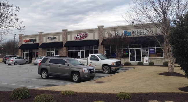
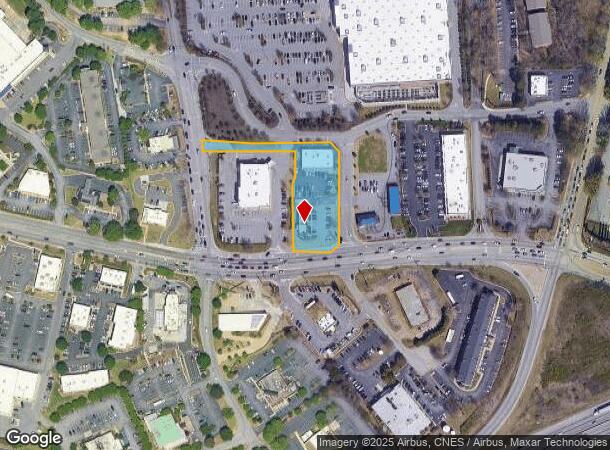
Property Record
3905 Pelham Rd, Greenville, SC 29615
NEARBY LISTINGS FOR SALE OR LEASE
Property Detail
3905 Pelham Rd
Greenville-Anderson-Mauldin, SC
Summary Plat For Obs Land Co Llc
0533.04-01-009.14
MAP 0533.04; 5
Stripcommercialcenter
Greenville
X
South Carolina
45045C0407E
009.14
2025
1.35 AC
2024
Pelham/I-85
002818
Greenville/Spartanburg
DEMOGRAPHICS near 3905 Pelham Rd
1 Mile
3 Mile
5 Mile
2024 Total Population
6,738
52,269
141,689
2029 Population
7,414
57,349
156,047
Pop Growth 2024-2029
+ 10.03%
+ 9.72%
+ 10.13%
Average Age
41
41
40
2024 Total Households
3,055
21,021
58,162
HH Growth 2024-2029
+ 10.18%
+ 9.85%
+ 10.24%
Median Household Inc
$72,373
$92,891
$83,749
Avg Household Size
2.10
2.40
2.40
2024 Avg HH Vehicles
2.00
2.00
2.00
Median Home Value
$412,143
$335,175
$288,499
Median Year Built
1994
1992
1993
Nearby Places
Map Layers
Map Styles
 Street
 Aerial
- Restaurants
- Banks
- Shops
- Fitness
- Groceries
PUBLIC TRANSPORTATION
COMMUTER RAIL
Greenville Amtrak Station (Crescent - Amtrak)
DRIVE
WALK
Distance
Greenville Amtrak Station (Crescent - Amtrak)
17 min
9.5 mi
AIRPORT
Greenville Spartanburg International
DRIVE
WALK
Distance
Greenville Spartanburg International
10 min
4.9 mi
Freight Ports
North Charleston Terminal
DRIVE
WALK
Distance
North Charleston Terminal
227 min
201.0 mi
SALE & LEASE HISTORY
LISTING DATE
SALE/LEASE

Sep 25, 2016
For Lease
Nearby Properties
Address
Land Use
TOTAL SIZE
Lot Size
Zoning
Address
Land Use
TOTAL SIZE
Lot Size
Zoning
18.50 AC
RS
Address
Land Use
TOTAL SIZE
Lot Size
Zoning
2,355 SF
10.21 AC
RS
Address
Land Use
TOTAL SIZE
Lot Size
Zoning
223.09 AC
I1
Address
Land Use
TOTAL SIZE
Lot Size
Zoning
20.40 AC
RS
Address
Land Use
TOTAL SIZE
Lot Size
Zoning
38.86 AC
C2
Address
Land Use
TOTAL SIZE
Lot Size
Zoning
181.61 AC
C-2,I1
Address
Land Use
TOTAL SIZE
Lot Size
Zoning
17.53 AC
I1
Address
Land Use
TOTAL SIZE
Lot Size
Zoning
5.19 AC
PD
Address
Land Use
TOTAL SIZE
Lot Size
Zoning
6.97 AC
R12
Address
Land Use
TOTAL SIZE
Lot Size
Zoning
1,202 SF
14.38 AC
RS
Address
Land Use
TOTAL SIZE
Lot Size
Zoning
5.47 AC
C3
Address
Land Use
TOTAL SIZE
Lot Size
Zoning
91.80 AC
PD
Address
Land Use
TOTAL SIZE
Lot Size
Zoning
26.90 AC
C3
Address
Land Use
TOTAL SIZE
Lot Size
Zoning
4.80 AC
I1
Address
Land Use
TOTAL SIZE
Lot Size
Zoning
136.04 AC
I1
Address
Land Use
TOTAL SIZE
Lot Size
Zoning
21.48 AC
C3
Address
Land Use
TOTAL SIZE
Lot Size
Zoning
143.57 AC
I1
Address
Land Use
TOTAL SIZE
Lot Size
Zoning
5.80 AC
RS
Address
Land Use
TOTAL SIZE
Lot Size
Zoning
23.20 AC
PD
Address
Land Use
TOTAL SIZE
Lot Size
Zoning
43.58 AC
RS
Address
Land Use
TOTAL SIZE
Lot Size
Zoning
9.90 AC
I1
Address
Land Use
TOTAL SIZE
Lot Size
Zoning
62.23 AC
RS,R20
Address
Land Use
TOTAL SIZE
Lot Size
Zoning
15.26 AC
Address
Land Use
TOTAL SIZE
Lot Size
Zoning
2.73 AC
C3
Address
Land Use
TOTAL SIZE
Lot Size
Zoning
22.48 AC
I1
Address
Land Use
TOTAL SIZE
Lot Size
Zoning
9.27 AC
I1
Address
Land Use
TOTAL SIZE
Lot Size
Zoning
2.80 AC
I1
Address
Land Use
TOTAL SIZE
Lot Size
Zoning
88.98 AC
RS
Address
Land Use
TOTAL SIZE
Lot Size
Zoning
18.50 AC
PD
Address
Land Use
TOTAL SIZE
Lot Size
Zoning
3.59 AC
S1
The World's #1 Commercial Real Estate Marketplace
Connect with us
© 2025 CoStar Group
The information above has been obtained from sources believed reliable. While we do not doubt its accuracy we have not verified it and make no guarantee, warranty or representation about it. It is your responsibility to independently confirm its accuracy and completeness. Any projections, opinions, assumptions, or estimates used are for example only and do not represent the current or future performance of the property. The value of this transaction to you depends on tax and other factors which should be evaluated by your tax, financial, and legal advisors. You and your advisors should conduct a careful, independent investigation of the property to determine to your satisfaction the suitability of the property for your needs.