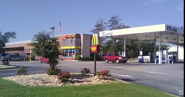
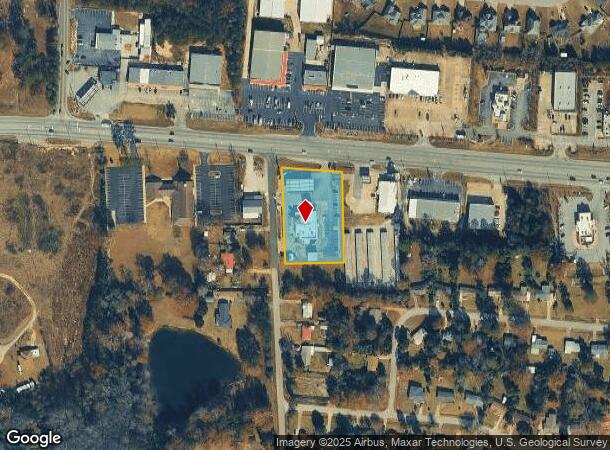
Property Record
3915 Us Highway 80 W, Phenix City, AL 36870
NEARBY LISTINGS FOR SALE OR LEASE
Property Detail
3915 Us Highway 80 W
04-06-13-02-002-008.001
S13T17R29 BEG SE INT US80 & ARMOUR RD E208 S294 W201 N TO PB
Restaurantdrivein
Russell
X
Alabama
01113C0155D
1.39 AC
2024
Russell County
2024
Columbus GA
030906
Columbus, GA-AL
6,660 SF
DEMOGRAPHICS near 3915 Us Highway 80 W
1 Mile
3 Mile
5 Mile
2024 Total Population
5,463
21,243
54,908
2029 Population
5,705
22,356
56,799
Pop Growth 2024-2029
+ 4.43%
+ 5.24%
+ 3.44%
Average Age
37
39
39
2024 Total Households
2,011
8,018
21,638
HH Growth 2024-2029
+ 3.98%
+ 4.93%
+ 3.15%
Median Household Inc
$56,505
$56,522
$52,277
Avg Household Size
2.70
2.60
2.50
2024 Avg HH Vehicles
2.00
2.00
2.00
Median Home Value
$151,487
$146,371
$153,545
Median Year Built
1995
1994
1991
Nearby Places
- Restaurants
- Banks
- Shops
- Fitness
- Groceries
PUBLIC TRANSPORTATION
AIRPORT
Columbus
DRIVE
WALK
Distance
Columbus
20 min
11.9 mi
Freight Ports
Port of Panama City
DRIVE
WALK
Distance
Port of Panama City
237 min
187.4 mi
Nearby Properties
Address
Land Use
TOTAL SIZE
Lot Size
Zoning
Address
Land Use
TOTAL SIZE
Lot Size
Zoning
41,937 SF
14 AC
Address
Land Use
TOTAL SIZE
Lot Size
Zoning
47,287 SF
8 AC
O
Address
Land Use
TOTAL SIZE
Lot Size
Zoning
6,852 SF
10.64 AC
Address
Land Use
TOTAL SIZE
Lot Size
Zoning
8,122 SF
4 AC
O
Address
Land Use
TOTAL SIZE
Lot Size
Zoning
9,168 SF
4 AC
O
Address
Land Use
TOTAL SIZE
Lot Size
Zoning
9,991 SF
2 AC
Address
Land Use
TOTAL SIZE
Lot Size
Zoning
18,225 SF
1.46 AC
O
Address
Land Use
TOTAL SIZE
Lot Size
Zoning
21,136 SF
11 AC
O
Address
Land Use
TOTAL SIZE
Lot Size
Zoning
3,456 SF
4.15 AC
O
Address
Land Use
TOTAL SIZE
Lot Size
Zoning
10,346 SF
2.94 AC
Address
Land Use
TOTAL SIZE
Lot Size
Zoning
12,760 SF
2 AC
Address
Land Use
TOTAL SIZE
Lot Size
Zoning
12,000 SF
1.91 AC
O
Address
Land Use
TOTAL SIZE
Lot Size
Zoning
Address
Land Use
TOTAL SIZE
Lot Size
Zoning
6,171 SF
1.05 AC
Address
Land Use
TOTAL SIZE
Lot Size
Zoning
3,639 SF
1.60 AC
O
Address
Land Use
TOTAL SIZE
Lot Size
Zoning
9,090 SF
1.05 AC
Address
Land Use
TOTAL SIZE
Lot Size
Zoning
3,162 SF
1.07 AC
O
Address
Land Use
TOTAL SIZE
Lot Size
Zoning
8,748 SF
2 AC
O
Address
Land Use
TOTAL SIZE
Lot Size
Zoning
3,530 SF
2 AC
O
Address
Land Use
TOTAL SIZE
Lot Size
Zoning
1,540 SF
2 AC
Address
Land Use
TOTAL SIZE
Lot Size
Zoning
1,932 SF
0.73 AC
Address
Land Use
TOTAL SIZE
Lot Size
Zoning
1,676 SF
0.72 AC
Address
Land Use
TOTAL SIZE
Lot Size
Zoning
9,100 SF
1.18 AC
O
Address
Land Use
TOTAL SIZE
Lot Size
Zoning
3,608 SF
0.74 AC
Address
Land Use
TOTAL SIZE
Lot Size
Zoning
12,044 SF
1.30 AC
Address
Land Use
TOTAL SIZE
Lot Size
Zoning
9,100 SF
1.57 AC
Address
Land Use
TOTAL SIZE
Lot Size
Zoning
14,436 SF
6.92 AC
O
Address
Land Use
TOTAL SIZE
Lot Size
Zoning
7,296 SF
0.68 AC
Address
Land Use
TOTAL SIZE
Lot Size
Zoning
8,000 SF
2 AC
O
The World's #1 Commercial Real Estate Marketplace
Connect with us
© 2025 CoStar Group
The information above has been obtained from sources believed reliable. While we do not doubt its accuracy we have not verified it and make no guarantee, warranty or representation about it. It is your responsibility to independently confirm its accuracy and completeness. Any projections, opinions, assumptions, or estimates used are for example only and do not represent the current or future performance of the property. The value of this transaction to you depends on tax and other factors which should be evaluated by your tax, financial, and legal advisors. You and your advisors should conduct a careful, independent investigation of the property to determine to your satisfaction the suitability of the property for your needs.