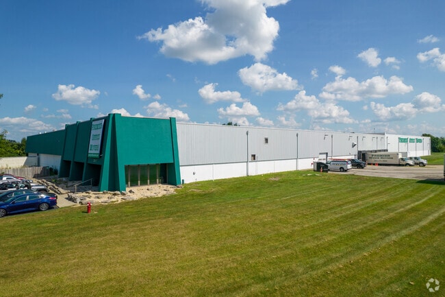
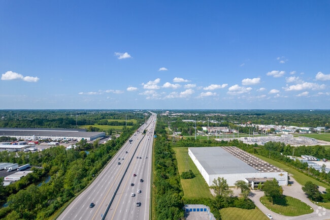
Property Record
3915 Zane Trace Dr, Columbus, OH 43228

Current Lease Availabilities
Property Detail
3915 Zane Trace Dr
560-180949
MUDSOCK RD ENTRY 547 5.453 ACRES
Industrialgeneral
Franklin
B and X Area of moderate flood hazard, usually the area between the limits of the 100-year and 500-year floods.
Ohio
2024
5.45 AC
2025
Hilliard
007941
Columbus
86,822 SF
Columbus, OH
NEARBY LISTINGS FOR SALE OR LEASE
DEMOGRAPHICS near 3915 Zane Trace Dr
1 mile
3 mile
5 mile
2025 Total Population
2,922
80,655
259,689
2030 Population
3,008
82,553
266,801
Pop Growth 2025-2030
+ 2.94%
+ 2.35%
+ 2.74%
Average Age
39
38
37
2025 Total Households
1,216
33,260
110,225
HH Growth 2025-2030
+ 2.96%
+ 2.55%
+ 2.75%
Median Household Inc
$101,000
$102,026
$82,249
Avg Household Size
2.40
2.40
2.30
2025 Avg HH Vehicles
2.00
2.00
2.00
Median Home Value
$337,202
$349,466
$350,084
Median Year Built
1983
1991
1984
Nearby Places
Map Layers
Map Styles
 Street
 Aerial
Layers
 Traffic
 Biking
Places
Listings with unknown addresses are not visible on the map
- Restaurants
- Banks
- Shops
- Fitness
- Groceries
PUBLIC TRANSPORTATION
AIRPORT
John Glenn Columbus International
Drive
Walk
Distance
John Glenn Columbus International
23 min
15.2 mi
Rickenbacker International
Drive
Walk
Distance
Rickenbacker International
29 min
21.0 mi
Freight Ports
Port of Toledo
Drive
Walk
Distance
Port of Toledo
179 min
132.5 mi
Nearby Properties
Address
Land Use
TOTAL SIZE
Lot Size
Zoning
Address
Land Use
TOTAL SIZE
Lot Size
Zoning
529,001 SF
0.15 AC
Address
Land Use
TOTAL SIZE
Lot Size
Zoning
555,347 SF
24.77 AC
Address
Land Use
TOTAL SIZE
Lot Size
Zoning
961,554 SF
75.09 AC
Address
Land Use
TOTAL SIZE
Lot Size
Zoning
87,654 SF
45.30 AC
Address
Land Use
TOTAL SIZE
Lot Size
Zoning
329,215 SF
8.33 AC
Address
Land Use
TOTAL SIZE
Lot Size
Zoning
34,521 SF
29.23 AC
Address
Land Use
TOTAL SIZE
Lot Size
Zoning
91,413 SF
0.14 AC
Address
Land Use
TOTAL SIZE
Lot Size
Zoning
50,837 SF
10.12 AC
Address
Land Use
TOTAL SIZE
Lot Size
Zoning
70,995 SF
38.78 AC
Address
Land Use
TOTAL SIZE
Lot Size
Zoning
255,902 SF
8.15 AC
Address
Land Use
TOTAL SIZE
Lot Size
Zoning
156,839 SF
48.45 AC
Address
Land Use
TOTAL SIZE
Lot Size
Zoning
155,280 SF
0.23 AC
Address
Land Use
TOTAL SIZE
Lot Size
Zoning
110,344 SF
19.06 AC
Address
Land Use
TOTAL SIZE
Lot Size
Zoning
82,510 SF
15.80 AC
Address
Land Use
TOTAL SIZE
Lot Size
Zoning
566,334 SF
58.62 AC
Address
Land Use
TOTAL SIZE
Lot Size
Zoning
96,602 SF
0.21 AC
Address
Land Use
TOTAL SIZE
Lot Size
Zoning
276,379 SF
14.75 AC
Address
Land Use
TOTAL SIZE
Lot Size
Zoning
142,979 SF
6.50 AC
Address
Land Use
TOTAL SIZE
Lot Size
Zoning
108,828 SF
23.51 AC
Address
Land Use
TOTAL SIZE
Lot Size
Zoning
293,744 SF
20.12 AC
Address
Land Use
TOTAL SIZE
Lot Size
Zoning
98,316 SF
10.81 AC
Address
Land Use
TOTAL SIZE
Lot Size
Zoning
157,875 SF
0.19 AC
Address
Land Use
TOTAL SIZE
Lot Size
Zoning
138,003 SF
2.94 AC
Address
Land Use
TOTAL SIZE
Lot Size
Zoning
69,650 SF
15.15 AC
Address
Land Use
TOTAL SIZE
Lot Size
Zoning
126,656 SF
15.83 AC
Address
Land Use
TOTAL SIZE
Lot Size
Zoning
429,544 SF
23.21 AC
Address
Land Use
TOTAL SIZE
Lot Size
Zoning
67,133 SF
16.67 AC
Address
Land Use
TOTAL SIZE
Lot Size
Zoning
249,644 SF
7.15 AC
Address
Land Use
TOTAL SIZE
Lot Size
Zoning
55,758 SF
7.83 AC
Address
Land Use
TOTAL SIZE
Lot Size
Zoning
64,133 SF
21.83 AC
The World's #1 Commercial Real Estate Marketplace
Connect with us
© 2026 CoStar Group
The information above has been obtained from sources believed reliable. While we do not doubt its accuracy we have not verified it and make no guarantee, warranty or representation about it. It is your responsibility to independently confirm its accuracy and completeness. Any projections, opinions, assumptions, or estimates used are for example only and do not represent the current or future performance of the property. The value of this transaction to you depends on tax and other factors which should be evaluated by your tax, financial, and legal advisors. You and your advisors should conduct a careful, independent investigation of the property to determine to your satisfaction the suitability of the property for your needs.