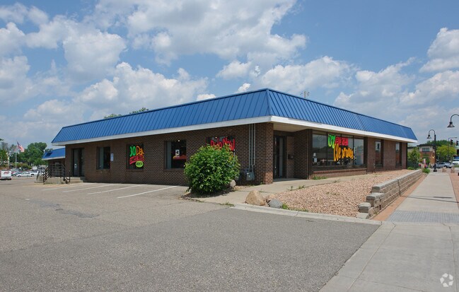
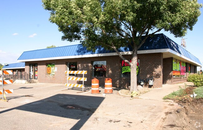
Property Record
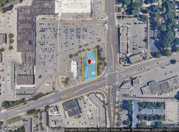
3916 W Old Shakopee Rd, Minneapolis, MN 55437

NEARBY LISTINGS FOR SALE OR LEASE
Property Detail
3916 W Old Shakopee Rd
19-027-24-41-0003
Unplatted 19 027 24
Commercialnec
UNPLATTED 19 027 24 BEG AT A PT 266 3/10 FT S FROM N LINE AND 153 FT W FROM E LINE OF SE 1/4 TH SWLY PAR WITH CTR LINE OF CO ROAD NO 1 DIS 140 FT TH S PAR WITH THE E LINE T IRREGULAR
X
Hennepin
27053C0462F
Minnesota
2024
0.87 AC
2024
Southdale
025803
Minneapolis/St Paul
11,667 SF
Minneapolis-St. Paul-Bloomington, MN-WI
DEMOGRAPHICS near 3916 W Old Shakopee Rd
1 Mile
3 Mile
5 Mile
2024 Total Population
10,457
53,737
186,273
2029 Population
10,222
53,017
186,283
Pop Growth 2024-2029
(2.25%)
(1.34%)
+ 0.01%
Average Age
43
43
42
2024 Total Households
4,188
22,567
77,063
HH Growth 2024-2029
(2.44%)
(1.48%)
(0.17%)
Median Household Inc
$98,998
$84,200
$85,655
Avg Household Size
2.40
2.30
2.30
2024 Avg HH Vehicles
2.00
2.00
2.00
Median Home Value
$310,435
$331,768
$326,395
Median Year Built
1963
1972
1975
Nearby Places
Map Layers
Map Styles
 Street
 Aerial
- Restaurants
- Banks
- Shops
- Fitness
- Groceries
PUBLIC TRANSPORTATION
AIRPORT
Minneapolis-St Paul International/Wold-Chamberlain
DRIVE
WALK
Distance
Minneapolis-St Paul International/Wold-Chamberlain
17 min
10.1 mi
Freight Ports
Port Milwaukee
DRIVE
WALK
Distance
Port Milwaukee
386 min
347.3 mi
SALE & LEASE HISTORY
LISTING DATE
SALE/LEASE

Jan 17, 2020
For Sale
Jan 09, 2018
For Lease
Nearby Properties
Address
Land Use
TOTAL SIZE
Lot Size
Zoning
Address
Land Use
TOTAL SIZE
Lot Size
Zoning
114,152 SF
18.42 AC
Address
Land Use
TOTAL SIZE
Lot Size
Zoning
129,658 SF
13.52 AC
Address
Land Use
TOTAL SIZE
Lot Size
Zoning
581,195 SF
37 AC
Address
Land Use
TOTAL SIZE
Lot Size
Zoning
105,658 SF
18.80 AC
Address
Land Use
TOTAL SIZE
Lot Size
Zoning
122,021 SF
21.74 AC
Address
Land Use
TOTAL SIZE
Lot Size
Zoning
45,147 SF
11.24 AC
Address
Land Use
TOTAL SIZE
Lot Size
Zoning
142,229 SF
26.61 AC
Address
Land Use
TOTAL SIZE
Lot Size
Zoning
394,700 SF
13.23 AC
Address
Land Use
TOTAL SIZE
Lot Size
Zoning
85,614 SF
11.77 AC
Address
Land Use
TOTAL SIZE
Lot Size
Zoning
102,132 SF
15.02 AC
Address
Land Use
TOTAL SIZE
Lot Size
Zoning
436,995 SF
22.36 AC
Address
Land Use
TOTAL SIZE
Lot Size
Zoning
70,904 SF
17.42 AC
Address
Land Use
TOTAL SIZE
Lot Size
Zoning
83,736 SF
11.69 AC
Address
Land Use
TOTAL SIZE
Lot Size
Zoning
75,831 SF
10.85 AC
Address
Land Use
TOTAL SIZE
Lot Size
Zoning
43,038 SF
10.81 AC
Address
Land Use
TOTAL SIZE
Lot Size
Zoning
310,400 SF
18.60 AC
Address
Land Use
TOTAL SIZE
Lot Size
Zoning
217,534 SF
18.77 AC
Address
Land Use
TOTAL SIZE
Lot Size
Zoning
150,867 SF
100.29 AC
Address
Land Use
TOTAL SIZE
Lot Size
Zoning
47,509 SF
4.64 AC
Address
Land Use
TOTAL SIZE
Lot Size
Zoning
206,005 SF
13.97 AC
Address
Land Use
TOTAL SIZE
Lot Size
Zoning
75,339 SF
3.99 AC
Address
Land Use
TOTAL SIZE
Lot Size
Zoning
153,796 SF
17.93 AC
Address
Land Use
TOTAL SIZE
Lot Size
Zoning
231,928 SF
16.63 AC
Address
Land Use
TOTAL SIZE
Lot Size
Zoning
179,288 SF
12.88 AC
Address
Land Use
TOTAL SIZE
Lot Size
Zoning
421,893 SF
21.17 AC
Address
Land Use
TOTAL SIZE
Lot Size
Zoning
340,588 SF
16.54 AC
Address
Land Use
TOTAL SIZE
Lot Size
Zoning
172,887 SF
21.45 AC
Address
Land Use
TOTAL SIZE
Lot Size
Zoning
13.99 AC
Address
Land Use
TOTAL SIZE
Lot Size
Zoning
20,545 SF
1.48 AC
Address
Land Use
TOTAL SIZE
Lot Size
Zoning
52,466 SF
5.31 AC
The World's #1 Commercial Real Estate Marketplace
Connect with us
© 2025 CoStar Group
The information above has been obtained from sources believed reliable. While we do not doubt its accuracy we have not verified it and make no guarantee, warranty or representation about it. It is your responsibility to independently confirm its accuracy and completeness. Any projections, opinions, assumptions, or estimates used are for example only and do not represent the current or future performance of the property. The value of this transaction to you depends on tax and other factors which should be evaluated by your tax, financial, and legal advisors. You and your advisors should conduct a careful, independent investigation of the property to determine to your satisfaction the suitability of the property for your needs.