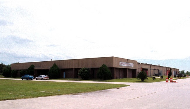
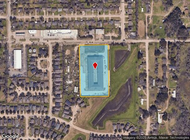
Property Record
3917 Anderson Rd, Houston, TX 77053
NEARBY LISTINGS FOR SALE OR LEASE
Property Detail
3917 Anderson Rd
0150750000086
Garden Place To Almeda
Outdoorrecreationbeachmountaindesert
TRS 22A-1 & 23A GARDEN PLACE TO ALMEDA
X
Harris
48039C0010K
Texas
2024
4.04 AC
2025
Southwest Far
330700
Houston
114,791 SF
Houston-The Woodlands-Sugar Land, TX
DEMOGRAPHICS near 3917 Anderson Rd
1 Mile
3 Mile
5 Mile
2024 Total Population
11,629
97,349
230,152
2029 Population
11,816
104,322
246,755
Pop Growth 2024-2029
+ 1.61%
+ 7.16%
+ 7.21%
Average Age
35
36
37
2024 Total Households
3,450
30,327
78,700
HH Growth 2024-2029
+ 1.54%
+ 7.44%
+ 7.14%
Median Household Inc
$54,254
$64,080
$67,488
Avg Household Size
3.30
3.10
2.90
2024 Avg HH Vehicles
2.00
2.00
2.00
Median Home Value
$121,852
$149,653
$200,525
Median Year Built
1988
1994
1993
Nearby Places
Map Layers
Map Styles
 Street
 Aerial
- Restaurants
- Banks
- Shops
- Fitness
- Groceries
PUBLIC TRANSPORTATION
AIRPORT
William P Hobby
DRIVE
WALK
Distance
William P Hobby
26 min
11.6 mi
George Bush Intcntl/Houston
DRIVE
WALK
Distance
George Bush Intcntl/Houston
45 min
31.6 mi
Freight Ports
Port of Houston
DRIVE
WALK
Distance
Port of Houston
30 min
17.1 mi
SALE & LEASE HISTORY
LISTING DATE
SALE/LEASE

Oct 23, 2018
For Sale
Nov 12, 2018
For Sale
May 10, 2018
For Sale
Jul 09, 2019
For Sale
Nearby Properties
Address
Land Use
TOTAL SIZE
Lot Size
Zoning
Address
Land Use
TOTAL SIZE
Lot Size
Zoning
1,139,160 SF
75.11 AC
Address
Land Use
TOTAL SIZE
Lot Size
Zoning
15.46 AC
Address
Land Use
TOTAL SIZE
Lot Size
Zoning
567,513 SF
5.82 AC
Address
Land Use
TOTAL SIZE
Lot Size
Zoning
542,333 SF
43.95 AC
Address
Land Use
TOTAL SIZE
Lot Size
Zoning
679,822 SF
27.54 AC
Address
Land Use
TOTAL SIZE
Lot Size
Zoning
347,124 SF
Address
Land Use
TOTAL SIZE
Lot Size
Zoning
429,368 SF
27.94 AC
Address
Land Use
TOTAL SIZE
Lot Size
Zoning
181,341 SF
16.73 AC
Address
Land Use
TOTAL SIZE
Lot Size
Zoning
460,711 SF
18.98 AC
Address
Land Use
TOTAL SIZE
Lot Size
Zoning
318,524 SF
20.44 AC
Address
Land Use
TOTAL SIZE
Lot Size
Zoning
670,850 SF
35.98 AC
Address
Land Use
TOTAL SIZE
Lot Size
Zoning
447,956 SF
18.42 AC
Address
Land Use
TOTAL SIZE
Lot Size
Zoning
400,696 SF
18.88 AC
Address
Land Use
TOTAL SIZE
Lot Size
Zoning
156,214 SF
13.50 AC
0025
Address
Land Use
TOTAL SIZE
Lot Size
Zoning
423,270 SF
32.95 AC
Address
Land Use
TOTAL SIZE
Lot Size
Zoning
281,889 SF
10.84 AC
Address
Land Use
TOTAL SIZE
Lot Size
Zoning
124,254 SF
22.68 AC
0002
Address
Land Use
TOTAL SIZE
Lot Size
Zoning
186,759 SF
42.60 AC
Address
Land Use
TOTAL SIZE
Lot Size
Zoning
299,046 SF
Address
Land Use
TOTAL SIZE
Lot Size
Zoning
264,384 SF
13.76 AC
Address
Land Use
TOTAL SIZE
Lot Size
Zoning
130,498 SF
93.44 AC
Address
Land Use
TOTAL SIZE
Lot Size
Zoning
170,092 SF
17.90 AC
Address
Land Use
TOTAL SIZE
Lot Size
Zoning
Address
Land Use
TOTAL SIZE
Lot Size
Zoning
3,108 SF
57.41 AC
Address
Land Use
TOTAL SIZE
Lot Size
Zoning
179,599 SF
16.45 AC
Address
Land Use
TOTAL SIZE
Lot Size
Zoning
169,176 SF
24.31 AC
Address
Land Use
TOTAL SIZE
Lot Size
Zoning
289,955 SF
11.96 AC
Address
Land Use
TOTAL SIZE
Lot Size
Zoning
15.48 AC
Address
Land Use
TOTAL SIZE
Lot Size
Zoning
215,900 SF
11.93 AC
Address
Land Use
TOTAL SIZE
Lot Size
Zoning
280,727 SF
11.25 AC
The World's #1 Commercial Real Estate Marketplace
Connect with us
© 2026 CoStar Group
The information above has been obtained from sources believed reliable. While we do not doubt its accuracy we have not verified it and make no guarantee, warranty or representation about it. It is your responsibility to independently confirm its accuracy and completeness. Any projections, opinions, assumptions, or estimates used are for example only and do not represent the current or future performance of the property. The value of this transaction to you depends on tax and other factors which should be evaluated by your tax, financial, and legal advisors. You and your advisors should conduct a careful, independent investigation of the property to determine to your satisfaction the suitability of the property for your needs.