Property Record
3917 E Memorial Rd, Edmond, OK 73013
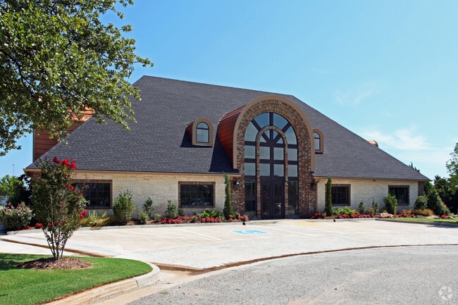

Property Detail
3917 E Memorial Rd
Oklahoma City, OK
OAKVIEW PROFESSIONAL POINTE PH II 000 002
211301010
Oklahoma
Commercialnec
Oklahoma
B and X Area of moderate flood hazard, usually the area between the limits of the 100-year and 500-year floods.
2
2024
1.22 AC
2025
Edmond
108109
Oklahoma City
8,917 SF
NEARBY LISTINGS FOR SALE OR LEASE
DEMOGRAPHICS near 3917 E Memorial Rd
1 mile
3 mile
5 mile
2025 Total Population
1,509
26,116
69,969
2030 Population
1,520
26,428
71,145
Pop Growth 2025-2030
+ 0.73%
+ 1.19%
+ 1.68%
Average Age
44
40
38
2025 Total Households
537
9,540
28,112
HH Growth 2025-2030
+ 0.74%
+ 1.33%
+ 1.84%
Median Household Inc
$156,322
$121,249
$91,480
Avg Household Size
2.70
2.60
2.40
2025 Avg HH Vehicles
2.00
2.00
2.00
Median Home Value
$526,786
$391,120
$352,369
Median Year Built
1986
1987
1988
Nearby Places
Map Layers
Map Styles
 Street
 Aerial
Layers
 Traffic
 Biking
Places
Listings with unknown addresses are not visible on the map
- Restaurants
- Banks
- Shops
- Fitness
- Groceries
PUBLIC TRANSPORTATION
AIRPORT
Will Rogers World
Drive
Walk
Distance
Will Rogers World
34 min
22.7 mi
Freight Ports
Tulsa Port Of Catoosa
Drive
Walk
Distance
Tulsa Port Of Catoosa
122 min
113.3 mi
SALE & LEASE HISTORY
LISTING DATE
SALE/LEASE

Sep 19, 2023
For Lease
Oct 08, 2018
For Lease
Jul 29, 2021
For Lease
Apr 24, 2019
For Lease
Nearby Properties
Address
Land Use
TOTAL SIZE
Lot Size
Zoning
Address
Land Use
TOTAL SIZE
Lot Size
Zoning
200,545 SF
24.93 AC
Address
Land Use
TOTAL SIZE
Lot Size
Zoning
32.33 AC
Address
Land Use
TOTAL SIZE
Lot Size
Zoning
285,136 SF
13.04 AC
PUD
Address
Land Use
TOTAL SIZE
Lot Size
Zoning
13,101 SF
1.22 AC
PUD
Address
Land Use
TOTAL SIZE
Lot Size
Zoning
234,208 SF
8.61 AC
PUD
Address
Land Use
TOTAL SIZE
Lot Size
Zoning
316,358 SF
39.39 AC
PUD
Address
Land Use
TOTAL SIZE
Lot Size
Zoning
132,226 SF
11.89 AC
Address
Land Use
TOTAL SIZE
Lot Size
Zoning
64,296 SF
8.43 AC
Address
Land Use
TOTAL SIZE
Lot Size
Zoning
72,273 SF
6.58 AC
Address
Land Use
TOTAL SIZE
Lot Size
Zoning
220,800 SF
14.55 AC
PUD
Address
Land Use
TOTAL SIZE
Lot Size
Zoning
197,818 SF
28.97 AC
Address
Land Use
TOTAL SIZE
Lot Size
Zoning
214,478 SF
22 AC
PUD
Address
Land Use
TOTAL SIZE
Lot Size
Zoning
28,150 SF
4.81 AC
Address
Land Use
TOTAL SIZE
Lot Size
Zoning
145,600 SF
16.38 AC
PUD
Address
Land Use
TOTAL SIZE
Lot Size
Zoning
134,995 SF
15.99 AC
Address
Land Use
TOTAL SIZE
Lot Size
Zoning
57,592 SF
8.96 AC
Address
Land Use
TOTAL SIZE
Lot Size
Zoning
66,514 SF
2.67 AC
Address
Land Use
TOTAL SIZE
Lot Size
Zoning
139,459 SF
5.17 AC
PUD
Address
Land Use
TOTAL SIZE
Lot Size
Zoning
1,360 SF
22.18 AC
Address
Land Use
TOTAL SIZE
Lot Size
Zoning
90,991 SF
18.36 AC
Address
Land Use
TOTAL SIZE
Lot Size
Zoning
85,041 SF
14.21 AC
PUD
Address
Land Use
TOTAL SIZE
Lot Size
Zoning
125,440 SF
10.92 AC
PUD
Address
Land Use
TOTAL SIZE
Lot Size
Zoning
60,396 SF
3.05 AC
Address
Land Use
TOTAL SIZE
Lot Size
Zoning
22,631 SF
8.88 AC
SPUD
Address
Land Use
TOTAL SIZE
Lot Size
Zoning
148,368 SF
7.89 AC
SPUD
Address
Land Use
TOTAL SIZE
Lot Size
Zoning
88,116 SF
38.22 AC
C-3
Address
Land Use
TOTAL SIZE
Lot Size
Zoning
45,414 SF
1.79 AC
SPUD
Address
Land Use
TOTAL SIZE
Lot Size
Zoning
99,577 SF
8.09 AC
PUD
Address
Land Use
TOTAL SIZE
Lot Size
Zoning
16,520 SF
5.05 AC
Address
Land Use
TOTAL SIZE
Lot Size
Zoning
138,600 SF
9.30 AC
PUD
The World's #1 Commercial Real Estate Marketplace
Connect with us
© 2026 CoStar Group
The information above has been obtained from sources believed reliable. While we do not doubt its accuracy we have not verified it and make no guarantee, warranty or representation about it. It is your responsibility to independently confirm its accuracy and completeness. Any projections, opinions, assumptions, or estimates used are for example only and do not represent the current or future performance of the property. The value of this transaction to you depends on tax and other factors which should be evaluated by your tax, financial, and legal advisors. You and your advisors should conduct a careful, independent investigation of the property to determine to your satisfaction the suitability of the property for your needs.