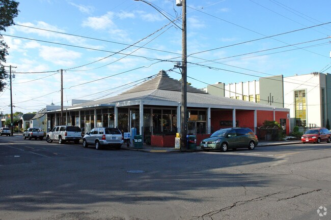
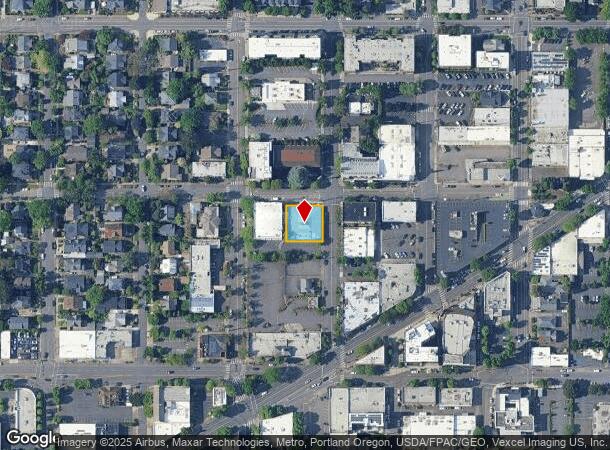
Property Record
3918 Ne Hancock St, Portland, OR 97212


NEARBY LISTINGS FOR SALE OR LEASE
Property Detail
3918 Ne Hancock St
Portland-Vancouver-Hillsboro, OR-WA
Rossmere
R262750
ROSSMERE, BLOCK 39, LOT 1&2
Commercialnec
Multnomah
ARE
Oregon
53011C0525D
1,2
2025
0.23 AC
2025
Gateway
002702
Portland
7,313 SF
DEMOGRAPHICS near 3918 Ne Hancock St
1 Mile
3 Mile
5 Mile
2024 Total Population
25,086
211,700
445,799
2029 Population
24,489
207,503
438,513
Pop Growth 2024-2029
(2.38%)
(1.98%)
(1.63%)
Average Age
42
40
40
2024 Total Households
10,780
97,225
203,191
HH Growth 2024-2029
(2.55%)
(2.08%)
(1.66%)
Median Household Inc
$112,824
$86,402
$81,973
Avg Household Size
2.30
2.10
2.10
2024 Avg HH Vehicles
2.00
1.00
1.00
Median Home Value
$750,906
$647,553
$570,958
Median Year Built
1946
1950
1958
Nearby Places
Map Layers
Map Styles
 Street
 Aerial
- Restaurants
- Banks
- Shops
- Fitness
- Groceries
PUBLIC TRANSPORTATION
TRANSIT/SUBWAY
Hollywood/Ne 42Nd Ave Max Station (MAX Blue Line - TriMet, MAX Green Line - TriMet, MAX Red Line - TriMet)
DRIVE
WALK
Distance
Hollywood/Ne 42Nd Ave Max Station (MAX Blue Line - TriMet, MAX Green Line - TriMet, MAX Red Line - TriMet)
5 min
6 min
0.4 mi
Hollywood/Ne 42Nd Transit Center (MAX Blue Line - Tri-County Metropolitan Transportation District of Oregon Rail (TriMet Rail), MAX Green Line - Tri-County Metropolitan Transportation District of Oregon Rail (TriMet Rail), MAX Red Line - Tri-County Metropolitan Transportation District of Oregon Rail (TriMet Rail))
DRIVE
WALK
Distance
Hollywood/Ne 42Nd Transit Center (MAX Blue Line - Tri-County Metropolitan Transportation District of Oregon Rail (TriMet Rail), MAX Green Line - Tri-County Metropolitan Transportation District of Oregon Rail (TriMet Rail), MAX Red Line - Tri-County Metropolitan Transportation District of Oregon Rail (TriMet Rail))
5 min
7 min
0.4 mi
COMMUTER RAIL
Portland (Amtrak Cascades - Amtrak, Coast Starlight - Amtrak, Empire Builder - Amtrak)
DRIVE
WALK
Distance
Portland (Amtrak Cascades - Amtrak, Coast Starlight - Amtrak, Empire Builder - Amtrak)
8 min
3.9 mi
AIRPORT
Portland International
DRIVE
WALK
Distance
Portland International
15 min
5.8 mi
Freight Ports
Port of Portland
DRIVE
WALK
Distance
Port of Portland
10 min
6.0 mi
Nearby Properties
Address
Land Use
TOTAL SIZE
Lot Size
Zoning
Address
Land Use
TOTAL SIZE
Lot Size
Zoning
395,815 SF
2.66 AC
IRD
Address
Land Use
TOTAL SIZE
Lot Size
Zoning
627,500 SF
16.60 AC
CX
Address
Land Use
TOTAL SIZE
Lot Size
Zoning
560,000 SF
0.15 AC
CX
Address
Land Use
TOTAL SIZE
Lot Size
Zoning
1.09 AC
EX
Address
Land Use
TOTAL SIZE
Lot Size
Zoning
417,324 SF
0.68 AC
CX
Address
Land Use
TOTAL SIZE
Lot Size
Zoning
257,700 SF
2.89 AC
EX
Address
Land Use
TOTAL SIZE
Lot Size
Zoning
178,785 SF
10.20 AC
R5
Address
Land Use
TOTAL SIZE
Lot Size
Zoning
197,027 SF
28.54 AC
R7H
Address
Land Use
TOTAL SIZE
Lot Size
Zoning
460,000 SF
0.92 AC
CX
Address
Land Use
TOTAL SIZE
Lot Size
Zoning
296,039 SF
11.70 AC
R5
Address
Land Use
TOTAL SIZE
Lot Size
Zoning
7.78 AC
EX
Address
Land Use
TOTAL SIZE
Lot Size
Zoning
183,664 SF
8.96 AC
R5
Address
Land Use
TOTAL SIZE
Lot Size
Zoning
243,371 SF
0.67 AC
CI2
Address
Land Use
TOTAL SIZE
Lot Size
Zoning
584,483 SF
0.90 AC
CX
Address
Land Use
TOTAL SIZE
Lot Size
Zoning
280,069 SF
18.31 AC
IR
Address
Land Use
TOTAL SIZE
Lot Size
Zoning
247,520 SF
7.74 AC
CX
Address
Land Use
TOTAL SIZE
Lot Size
Zoning
456,760 SF
0.53 AC
EX
Address
Land Use
TOTAL SIZE
Lot Size
Zoning
193,898 SF
2.50 AC
IRD
Address
Land Use
TOTAL SIZE
Lot Size
Zoning
134,398 SF
3.17 AC
CG
Address
Land Use
TOTAL SIZE
Lot Size
Zoning
387,000 SF
0.88 AC
CXD
Address
Land Use
TOTAL SIZE
Lot Size
Zoning
354,677 SF
0.79 AC
CX
Address
Land Use
TOTAL SIZE
Lot Size
Zoning
2,218,439 SF
21.88 AC
CX
Address
Land Use
TOTAL SIZE
Lot Size
Zoning
191,724 SF
0.45 AC
CXD
Address
Land Use
TOTAL SIZE
Lot Size
Zoning
265,300 SF
0.92 AC
EX
Address
Land Use
TOTAL SIZE
Lot Size
Zoning
360,053 SF
0.71 AC
EXD
Address
Land Use
TOTAL SIZE
Lot Size
Zoning
54,676 SF
190.32 AC
OS
Address
Land Use
TOTAL SIZE
Lot Size
Zoning
198,107 SF
4.03 AC
R2.5
Address
Land Use
TOTAL SIZE
Lot Size
Zoning
222,942 SF
0.80 AC
EX
Address
Land Use
TOTAL SIZE
Lot Size
Zoning
308,619 SF
0.92 AC
EX
Address
Land Use
TOTAL SIZE
Lot Size
Zoning
42,839,055 SF
19.25 AC
CI1
The World's #1 Commercial Real Estate Marketplace
Connect with us
© 2026 CoStar Group
The information above has been obtained from sources believed reliable. While we do not doubt its accuracy we have not verified it and make no guarantee, warranty or representation about it. It is your responsibility to independently confirm its accuracy and completeness. Any projections, opinions, assumptions, or estimates used are for example only and do not represent the current or future performance of the property. The value of this transaction to you depends on tax and other factors which should be evaluated by your tax, financial, and legal advisors. You and your advisors should conduct a careful, independent investigation of the property to determine to your satisfaction the suitability of the property for your needs.