Property Record
3918 W Wall St, Midland, TX 79703
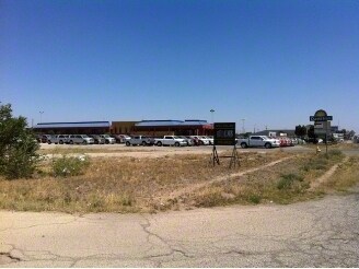

Property Detail
3918 W Wall St
Midland, TX
ACRES: 2.097 BLK: 082 LOTS: 024 & 25 LESS ADDN: PERMIAN ESTATES .14 AC
R000038-828
MIDLAND
Officebuilding
Texas
LR3
24-25
2025
2.10 AC
2025
Midland & Odessa
001300
Other Market Areas
13,920 SF
NEARBY LISTINGS FOR SALE OR LEASE
DEMOGRAPHICS near 3918 W Wall St
1 mile
3 mile
5 mile
2025 Total Population
7,318
60,907
137,957
2030 Population
7,918
66,767
151,794
Pop Growth 2025-2030
+ 8.20%
+ 9.62%
+ 10.03%
Average Age
35
35
35
2025 Total Households
2,379
21,747
50,603
HH Growth 2025-2030
+ 9.37%
+ 10.85%
+ 11.27%
Median Household Inc
$71,695
$79,623
$85,710
Avg Household Size
3.00
2.70
2.60
2025 Avg HH Vehicles
2.00
2.00
2.00
Median Home Value
$206,582
$247,568
$295,998
Median Year Built
1957
1974
1984
Nearby Places
Map Layers
Map Styles
 Street
 Aerial
Transit
 Traffic
 Biking
Places
Listings with unknown addresses are not visible on the map
- Restaurants
- Banks
- Shops
- Fitness
- Groceries
PUBLIC TRANSPORTATION
AIRPORT
Midland International Air And Space Port
Drive
Walk
Distance
Midland International Air And Space Port
13 min
8.0 mi
Freight Ports
Calhoun Port
Drive
Walk
Distance
Calhoun Port
529 min
473.8 mi
Nearby Properties
Address
Land Use
TOTAL SIZE
Lot Size
Zoning
Address
Land Use
TOTAL SIZE
Lot Size
Zoning
322,000 SF
24.88 AC
Address
Land Use
TOTAL SIZE
Lot Size
Zoning
25,575 SF
8.90 AC
Address
Land Use
TOTAL SIZE
Lot Size
Zoning
56,157 SF
18.19 AC
PDOC
Address
Land Use
TOTAL SIZE
Lot Size
Zoning
15,052 SF
4.68 AC
C1
Address
Land Use
TOTAL SIZE
Lot Size
Zoning
2,339 SF
17.14 AC
Address
Land Use
TOTAL SIZE
Lot Size
Zoning
2,453 SF
13.68 AC
Address
Land Use
TOTAL SIZE
Lot Size
Zoning
24,000 SF
11.87 AC
Address
Land Use
TOTAL SIZE
Lot Size
Zoning
29,645 SF
2.07 AC
C1
Address
Land Use
TOTAL SIZE
Lot Size
Zoning
28,750 SF
10.11 AC
Address
Land Use
TOTAL SIZE
Lot Size
Zoning
8,004 SF
3.58 AC
C1
Address
Land Use
TOTAL SIZE
Lot Size
Zoning
Address
Land Use
TOTAL SIZE
Lot Size
Zoning
15,000 SF
39.46 AC
PDHD
Address
Land Use
TOTAL SIZE
Lot Size
Zoning
44,784 SF
11.97 AC
MF1
Address
Land Use
TOTAL SIZE
Lot Size
Zoning
6,864 SF
10.35 AC
Address
Land Use
TOTAL SIZE
Lot Size
Zoning
46,512 SF
0.96 AC
C1
Address
Land Use
TOTAL SIZE
Lot Size
Zoning
209,680 SF
6.16 AC
Address
Land Use
TOTAL SIZE
Lot Size
Zoning
7,008 SF
0.96 AC
C1
Address
Land Use
TOTAL SIZE
Lot Size
Zoning
41,790 SF
1.50 AC
C1
Address
Land Use
TOTAL SIZE
Lot Size
Zoning
5,600 SF
10.18 AC
PDMX
Address
Land Use
TOTAL SIZE
Lot Size
Zoning
1,618 SF
4.18 AC
Address
Land Use
TOTAL SIZE
Lot Size
Zoning
276 SF
0.48 AC
C1
Address
Land Use
TOTAL SIZE
Lot Size
Zoning
1,868 SF
8.47 AC
MF1
Address
Land Use
TOTAL SIZE
Lot Size
Zoning
111,354 SF
8.34 AC
Address
Land Use
TOTAL SIZE
Lot Size
Zoning
137,457 SF
8.73 AC
MF1
Address
Land Use
TOTAL SIZE
Lot Size
Zoning
442 SF
2.99 AC
Address
Land Use
TOTAL SIZE
Lot Size
Zoning
1,956 SF
7.58 AC
MF1
Address
Land Use
TOTAL SIZE
Lot Size
Zoning
86,922 SF
1.87 AC
PDMC
Address
Land Use
TOTAL SIZE
Lot Size
Zoning
6,510 SF
0.48 AC
C1
Address
Land Use
TOTAL SIZE
Lot Size
Zoning
218,900 SF
0.40 AC
C1
Address
Land Use
TOTAL SIZE
Lot Size
Zoning
1,116 SF
0.56 AC
C1
The World's #1 Commercial Real Estate Marketplace
Connect with us
© 2026 CoStar Group
The information above has been obtained from sources believed reliable. While we do not doubt its accuracy we have not verified it and make no guarantee, warranty or representation about it. It is your responsibility to independently confirm its accuracy and completeness. Any projections, opinions, assumptions, or estimates used are for example only and do not represent the current or future performance of the property. The value of this transaction to you depends on tax and other factors which should be evaluated by your tax, financial, and legal advisors. You and your advisors should conduct a careful, independent investigation of the property to determine to your satisfaction the suitability of the property for your needs.