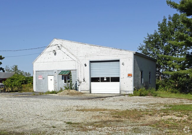
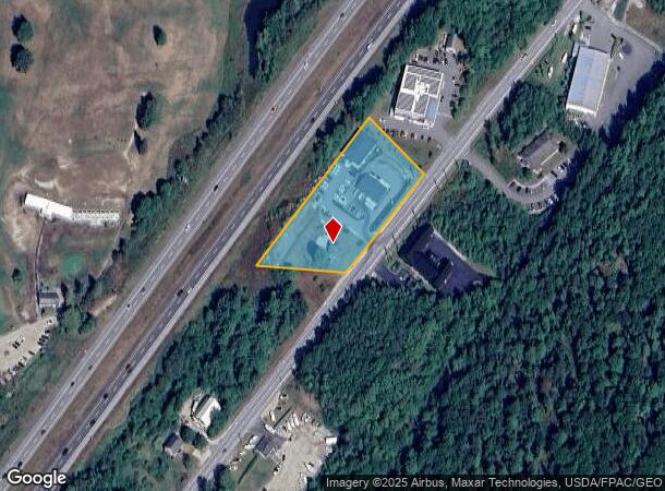
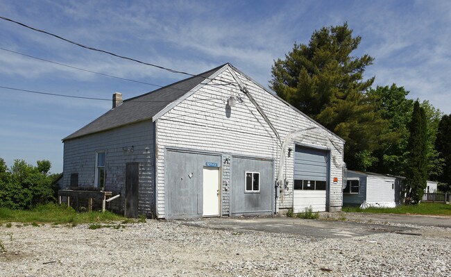
Property Record
392 Us Route 1, Freeport, ME 04032
NEARBY LISTINGS FOR SALE OR LEASE
Property Detail
392 Us Route 1
Commercialnec
Cumberland
X
Maine
23005C0533F
1.84 AC
2024
NE Cumberland County
2024
Portland/South Portland
004502
Portland-South Portland, ME
874 SF
FPRT-000026-000041
DEMOGRAPHICS near 392 Us Route 1
1 Mile
3 Mile
5 Mile
2024 Total Population
649
7,319
19,112
2029 Population
671
7,607
19,843
Pop Growth 2024-2029
+ 3.39%
+ 3.93%
+ 3.82%
Average Age
46
44
44
2024 Total Households
249
2,975
7,552
HH Growth 2024-2029
+ 3.21%
+ 3.90%
+ 3.83%
Median Household Inc
$101,852
$84,447
$92,444
Avg Household Size
2.40
2.30
2.40
2024 Avg HH Vehicles
2.00
2.00
2.00
Median Home Value
$519,444
$472,740
$479,071
Median Year Built
1976
1978
1976
Nearby Places
- Restaurants
- Banks
- Shops
- Fitness
- Groceries
PUBLIC TRANSPORTATION
COMMUTER RAIL
Freeport Amtrak Station (Downeaster - Amtrak)
DRIVE
WALK
Distance
Freeport Amtrak Station (Downeaster - Amtrak)
4 min
2.3 mi
AIRPORT
Portland International Jetport
DRIVE
WALK
Distance
Portland International Jetport
26 min
18.0 mi
Freight Ports
Portland, ME
DRIVE
WALK
Distance
Portland, ME
20 min
14.9 mi
SALE & LEASE HISTORY
LISTING DATE
SALE/LEASE

May 22, 2017
For Sale
Dec 13, 2016
For Sale
Nearby Properties
Address
Land Use
TOTAL SIZE
Lot Size
Zoning
Address
Land Use
TOTAL SIZE
Lot Size
Zoning
90 AC
CM03
Address
Land Use
TOTAL SIZE
Lot Size
Zoning
3.63 AC
CM01
Address
Land Use
TOTAL SIZE
Lot Size
Zoning
7.53 AC
CM01
Address
Land Use
TOTAL SIZE
Lot Size
Zoning
24 AC
CM02
Address
Land Use
TOTAL SIZE
Lot Size
Zoning
38.65 AC
CM03
Address
Land Use
TOTAL SIZE
Lot Size
Zoning
350,171 SF
78.45 AC
CM03
Address
Land Use
TOTAL SIZE
Lot Size
Zoning
432,630 SF
CM03
Address
Land Use
TOTAL SIZE
Lot Size
Zoning
20 AC
CM03
Address
Land Use
TOTAL SIZE
Lot Size
Zoning
0.66 AC
1400
Address
Land Use
TOTAL SIZE
Lot Size
Zoning
2,469 SF
3.84 AC
CM03
Address
Land Use
TOTAL SIZE
Lot Size
Zoning
93,752 SF
10.86 AC
21
Address
Land Use
TOTAL SIZE
Lot Size
Zoning
5.15 AC
CM03
Address
Land Use
TOTAL SIZE
Lot Size
Zoning
9.70 AC
CD4-C1
Address
Land Use
TOTAL SIZE
Lot Size
Zoning
1.46 AC
CM03
Address
Land Use
TOTAL SIZE
Lot Size
Zoning
45,829 SF
0.94 AC
CM01
Address
Land Use
TOTAL SIZE
Lot Size
Zoning
58,718 SF
13 AC
CM04
Address
Land Use
TOTAL SIZE
Lot Size
Zoning
59,699 SF
6.60 AC
CM02
Address
Land Use
TOTAL SIZE
Lot Size
Zoning
22.47 AC
1150
Address
Land Use
TOTAL SIZE
Lot Size
Zoning
60,270 SF
21.80 AC
550
Address
Land Use
TOTAL SIZE
Lot Size
Zoning
18 AC
13
Address
Land Use
TOTAL SIZE
Lot Size
Zoning
Address
Land Use
TOTAL SIZE
Lot Size
Zoning
29,680 SF
0.79 AC
CM01
Address
Land Use
TOTAL SIZE
Lot Size
Zoning
39,225 SF
21.43 AC
CM03
Address
Land Use
TOTAL SIZE
Lot Size
Zoning
45,879 SF
6.62 AC
CM04
Address
Land Use
TOTAL SIZE
Lot Size
Zoning
1.01 AC
CM02
Address
Land Use
TOTAL SIZE
Lot Size
Zoning
41,451 SF
2.90 AC
CM03
Address
Land Use
TOTAL SIZE
Lot Size
Zoning
38,209 SF
2.26 AC
CM02
Address
Land Use
TOTAL SIZE
Lot Size
Zoning
62,857 SF
23.10 AC
CM04
Address
Land Use
TOTAL SIZE
Lot Size
Zoning
38,323 SF
2.14 AC
CM03
Address
Land Use
TOTAL SIZE
Lot Size
Zoning
5.11 AC
CM02
The World's #1 Commercial Real Estate Marketplace
Connect with us
© 2025 CoStar Group
The information above has been obtained from sources believed reliable. While we do not doubt its accuracy we have not verified it and make no guarantee, warranty or representation about it. It is your responsibility to independently confirm its accuracy and completeness. Any projections, opinions, assumptions, or estimates used are for example only and do not represent the current or future performance of the property. The value of this transaction to you depends on tax and other factors which should be evaluated by your tax, financial, and legal advisors. You and your advisors should conduct a careful, independent investigation of the property to determine to your satisfaction the suitability of the property for your needs.