Property Record
392 W Walton Blvd, Pontiac, MI 48340
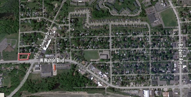


This Property Is For Sale
NEARBY LISTINGS FOR SALE OR LEASE
Property Detail
392 W Walton Blvd
Detroit-Warren-Dearborn, MI
Walton
14-07-477-005
T3N, R10E, SEC 7 PART OF SE 1/4 BEG AT INTER OF CEN LINE OF NEWARK RD WITH CEN LINE OF WALTON BLVD, TH N 168.08 FT ALG CEN
Residentialacreage
Oakland
X
Michigan
26125C0362F
0.60 AC
2024
Lakes Area
2025
Detroit
141400
DEMOGRAPHICS near 392 W Walton Blvd
1 Mile
3 Mile
5 Mile
2024 Total Population
10,250
62,668
151,548
2029 Population
10,161
62,476
150,877
Pop Growth 2024-2029
(0.87%)
(0.31%)
(0.44%)
Average Age
38
39
40
2024 Total Households
4,280
25,289
63,426
HH Growth 2024-2029
(0.91%)
(0.36%)
(0.53%)
Median Household Inc
$37,093
$52,622
$56,246
Avg Household Size
2.30
2.40
2.30
2024 Avg HH Vehicles
1.00
2.00
2.00
Median Home Value
$106,383
$154,287
$187,138
Median Year Built
1965
1965
1969
Nearby Places
Map Layers
Map Styles
 Street
 Aerial
- Restaurants
- Banks
- Shops
- Fitness
- Groceries
PUBLIC TRANSPORTATION
COMMUTER RAIL
Pontiac Amtrak Station (Wolverine - Amtrak)
DRIVE
WALK
Distance
Pontiac Amtrak Station (Wolverine - Amtrak)
9 min
4.4 mi
AIRPORT
Bishop International
DRIVE
WALK
Distance
Bishop International
54 min
36.8 mi
Freight Ports
Port of Toledo
DRIVE
WALK
Distance
Port of Toledo
112 min
85.1 mi
Nearby Properties
Address
Land Use
TOTAL SIZE
Lot Size
Zoning
Address
Land Use
TOTAL SIZE
Lot Size
Zoning
1,421,000 SF
170.30 AC
B2
Address
Land Use
TOTAL SIZE
Lot Size
Zoning
527,000 SF
36.03 AC
Address
Land Use
TOTAL SIZE
Lot Size
Zoning
420,858 SF
65.07 AC
Address
Land Use
TOTAL SIZE
Lot Size
Zoning
1,771,589 SF
96.73 AC
Address
Land Use
TOTAL SIZE
Lot Size
Zoning
426,034 SF
24.99 AC
AI
Address
Land Use
TOTAL SIZE
Lot Size
Zoning
280,000 SF
Address
Land Use
TOTAL SIZE
Lot Size
Zoning
327,435 SF
39.93 AC
R2
Address
Land Use
TOTAL SIZE
Lot Size
Zoning
455,045 SF
23.47 AC
I1
Address
Land Use
TOTAL SIZE
Lot Size
Zoning
232,860 SF
28.30 AC
I1
Address
Land Use
TOTAL SIZE
Lot Size
Zoning
171,242 SF
11.86 AC
Address
Land Use
TOTAL SIZE
Lot Size
Zoning
137,086 SF
9.29 AC
I1
Address
Land Use
TOTAL SIZE
Lot Size
Zoning
102,379 SF
28.20 AC
Address
Land Use
TOTAL SIZE
Lot Size
Zoning
218,870 SF
23.21 AC
Address
Land Use
TOTAL SIZE
Lot Size
Zoning
124,104 SF
Address
Land Use
TOTAL SIZE
Lot Size
Zoning
79,263 SF
22.27 AC
Address
Land Use
TOTAL SIZE
Lot Size
Zoning
174,265 SF
13.50 AC
TR
Address
Land Use
TOTAL SIZE
Lot Size
Zoning
130,414 SF
10.75 AC
AI
Address
Land Use
TOTAL SIZE
Lot Size
Zoning
65,432 SF
16.57 AC
Address
Land Use
TOTAL SIZE
Lot Size
Zoning
145,872 SF
14.81 AC
AI
Address
Land Use
TOTAL SIZE
Lot Size
Zoning
137,086 SF
Address
Land Use
TOTAL SIZE
Lot Size
Zoning
124,104 SF
7.98 AC
I1
Address
Land Use
TOTAL SIZE
Lot Size
Zoning
125,108 SF
27.93 AC
I1
Address
Land Use
TOTAL SIZE
Lot Size
Zoning
110,521 SF
3.23 AC
B2
Address
Land Use
TOTAL SIZE
Lot Size
Zoning
177,394 SF
10.08 AC
I1
Address
Land Use
TOTAL SIZE
Lot Size
Zoning
71,140 SF
Address
Land Use
TOTAL SIZE
Lot Size
Zoning
1,870,974 SF
61.73 AC
Address
Land Use
TOTAL SIZE
Lot Size
Zoning
144,889 SF
8.09 AC
Address
Land Use
TOTAL SIZE
Lot Size
Zoning
150,090 SF
11.74 AC
I1
Address
Land Use
TOTAL SIZE
Lot Size
Zoning
245,940 SF
28.74 AC
Address
Land Use
TOTAL SIZE
Lot Size
Zoning
143,701 SF
9.85 AC
AI
The World's #1 Commercial Real Estate Marketplace
Connect with us
© 2026 CoStar Group
The information above has been obtained from sources believed reliable. While we do not doubt its accuracy we have not verified it and make no guarantee, warranty or representation about it. It is your responsibility to independently confirm its accuracy and completeness. Any projections, opinions, assumptions, or estimates used are for example only and do not represent the current or future performance of the property. The value of this transaction to you depends on tax and other factors which should be evaluated by your tax, financial, and legal advisors. You and your advisors should conduct a careful, independent investigation of the property to determine to your satisfaction the suitability of the property for your needs.