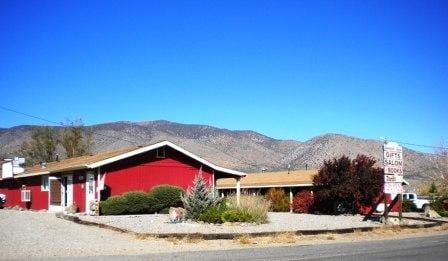
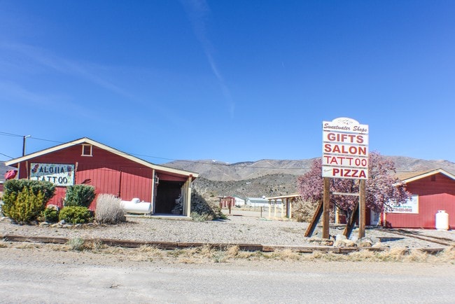
Property Record
3920 Carter Dr, Wellington, NV 89444


NEARBY LISTINGS FOR SALE OR LEASE
-
-
View all Wellington listings for sale on LoopNet.com
Property Detail
3920 Carter Dr
1022-15-001-106
Topaz Ranch Est #4
Commercialnec
TOPAZ RANCH EST #4 BLOCK V
X
Douglas
06003C0275B
Nevada
2024
1 AC
2025
Douglas County
002500
Reno/Sparks
3,260 SF
Gardnerville Ranchos, NV
DEMOGRAPHICS near 3920 Carter Dr
1 Mile
3 Mile
5 Mile
2024 Total Population
753
2,042
2,580
2029 Population
774
2,097
2,646
Pop Growth 2024-2029
+ 2.79%
+ 2.69%
+ 2.56%
Average Age
54
52
51
2024 Total Households
356
948
1,178
HH Growth 2024-2029
+ 2.81%
+ 2.74%
+ 2.63%
Median Household Inc
$56,249
$57,010
$57,408
Avg Household Size
2.10
2.10
2.20
2024 Avg HH Vehicles
2.00
2.00
2.00
Median Home Value
$347,500
$354,187
$358,823
Median Year Built
1986
1987
1987
Nearby Places
Map Layers
Map Styles
 Street
 Aerial
- Restaurants
- Banks
- Shops
- Fitness
- Groceries
SALE & LEASE HISTORY
LISTING DATE
SALE/LEASE

Sep 23, 2016
For Sale
Feb 09, 2020
For Sale
Nearby Properties
Address
Land Use
TOTAL SIZE
Lot Size
Zoning
Address
Land Use
TOTAL SIZE
Lot Size
Zoning
2,444 SF
211 AC
Address
Land Use
TOTAL SIZE
Lot Size
Zoning
8,400 SF
1 AC
Address
Land Use
TOTAL SIZE
Lot Size
Zoning
4,313 SF
1.47 AC
Address
Land Use
TOTAL SIZE
Lot Size
Zoning
24,205 SF
5 AC
Address
Land Use
TOTAL SIZE
Lot Size
Zoning
8,400 SF
0.70 AC
Address
Land Use
TOTAL SIZE
Lot Size
Zoning
3,600 SF
1.27 AC
Address
Land Use
TOTAL SIZE
Lot Size
Zoning
Address
Land Use
TOTAL SIZE
Lot Size
Zoning
2,148 SF
1.72 AC
Address
Land Use
TOTAL SIZE
Lot Size
Zoning
3,603 SF
8.20 AC
Address
Land Use
TOTAL SIZE
Lot Size
Zoning
20.61 AC
Address
Land Use
TOTAL SIZE
Lot Size
Zoning
5.85 AC
Address
Land Use
TOTAL SIZE
Lot Size
Zoning
4,280 SF
2 AC
Address
Land Use
TOTAL SIZE
Lot Size
Zoning
2,650 SF
8.90 AC
Address
Land Use
TOTAL SIZE
Lot Size
Zoning
4,400 SF
3.16 AC
Address
Land Use
TOTAL SIZE
Lot Size
Zoning
918 SF
3.82 AC
Address
Land Use
TOTAL SIZE
Lot Size
Zoning
Address
Land Use
TOTAL SIZE
Lot Size
Zoning
Address
Land Use
TOTAL SIZE
Lot Size
Zoning
10.83 AC
Address
Land Use
TOTAL SIZE
Lot Size
Zoning
15.26 AC
Address
Land Use
TOTAL SIZE
Lot Size
Zoning
1,490 SF
2.93 AC
Address
Land Use
TOTAL SIZE
Lot Size
Zoning
Address
Land Use
TOTAL SIZE
Lot Size
Zoning
9.34 AC
Address
Land Use
TOTAL SIZE
Lot Size
Zoning
6.50 AC
Address
Land Use
TOTAL SIZE
Lot Size
Zoning
1,728 SF
1.29 AC
Address
Land Use
TOTAL SIZE
Lot Size
Zoning
4,960 SF
1 AC
Address
Land Use
TOTAL SIZE
Lot Size
Zoning
Address
Land Use
TOTAL SIZE
Lot Size
Zoning
4,000 SF
4.99 AC
Address
Land Use
TOTAL SIZE
Lot Size
Zoning
1,281 SF
1.39 AC
The World's #1 Commercial Real Estate Marketplace
Connect with us
© 2025 CoStar Group
The information above has been obtained from sources believed reliable. While we do not doubt its accuracy we have not verified it and make no guarantee, warranty or representation about it. It is your responsibility to independently confirm its accuracy and completeness. Any projections, opinions, assumptions, or estimates used are for example only and do not represent the current or future performance of the property. The value of this transaction to you depends on tax and other factors which should be evaluated by your tax, financial, and legal advisors. You and your advisors should conduct a careful, independent investigation of the property to determine to your satisfaction the suitability of the property for your needs.