Property Record
3920 Cook Blvd, Chesapeake, VA 23323
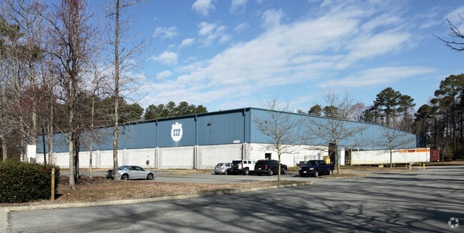

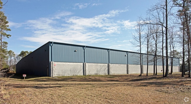
Property Detail
3920 Cook Blvd
0230000002300
PAR 103 SUBD PAR 103 CAVALIER INDUSTRIAL PK 5.628
Distributionwarehouseregional
Chesapeake City
M1: LIGHT
Virginia
B and X Area of moderate flood hazard, usually the area between the limits of the 100-year and 500-year floods.
5.63 AC
2024
Cavalier
2025
Hampton Roads
021407
Virginia Beach-Chesapeake-Norfolk, VA-NC
90,000 SF
NEARBY LISTINGS FOR SALE OR LEASE
DEMOGRAPHICS near 3920 Cook Blvd
1 mile
3 mile
5 mile
2025 Total Population
2,368
47,616
127,770
2030 Population
2,339
47,479
128,367
Pop Growth 2025-2030
(1.22%)
(0.29%)
+ 0.47%
Average Age
46
40
39
2025 Total Households
932
17,979
47,865
HH Growth 2025-2030
(1.29%)
(0.40%)
+ 0.39%
Median Household Inc
$66,923
$71,249
$72,246
Avg Household Size
2.50
2.60
2.60
2025 Avg HH Vehicles
2.00
2.00
2.00
Median Home Value
$328,723
$271,233
$299,325
Median Year Built
1977
1972
1974
Nearby Places
Map Layers
Map Styles
 Street
 Aerial
Layers
 Traffic
 Biking
Places
Listings with unknown addresses are not visible on the map
- Restaurants
- Banks
- Shops
- Fitness
- Groceries
PUBLIC TRANSPORTATION
COMMUTER RAIL
Drive
Walk
Distance
18 min
8.6 mi
AIRPORT
Norfolk International
Drive
Walk
Distance
Norfolk International
30 min
15.0 mi
Newport News/Williamsburg International
Drive
Walk
Distance
Newport News/Williamsburg International
52 min
36.1 mi
Freight Ports
Virginia Port Authority - Portsmouth
Drive
Walk
Distance
Virginia Port Authority - Portsmouth
19 min
7.9 mi
Nearby Properties
Address
Land Use
TOTAL SIZE
Lot Size
Zoning
Address
Land Use
TOTAL SIZE
Lot Size
Zoning
250,000 SF
38 AC
MUH
Address
Land Use
TOTAL SIZE
Lot Size
Zoning
300,829 SF
38.40 AC
IL
Address
Land Use
TOTAL SIZE
Lot Size
Zoning
71,039 SF
22.69 AC
R10S: RESI
Address
Land Use
TOTAL SIZE
Lot Size
Zoning
1,684 SF
23.36 AC
RMF1: MULT
Address
Land Use
TOTAL SIZE
Lot Size
Zoning
120,471 SF
10.32 AC
M1: LIGHT
Address
Land Use
TOTAL SIZE
Lot Size
Zoning
295,000 SF
27.89 AC
M1: LIGHT
Address
Land Use
TOTAL SIZE
Lot Size
Zoning
178,068 SF
14.72 AC
M1: LIGHT
Address
Land Use
TOTAL SIZE
Lot Size
Zoning
206,652 SF
64.32 AC
A1: AGRICU
Address
Land Use
TOTAL SIZE
Lot Size
Zoning
264,975 SF
50.36 AC
R10S: RESI
Address
Land Use
TOTAL SIZE
Lot Size
Zoning
333,833 SF
23.53 AC
M1: LIGHT
Address
Land Use
TOTAL SIZE
Lot Size
Zoning
241,397 SF
50.65 AC
M1: LIGHT
Address
Land Use
TOTAL SIZE
Lot Size
Zoning
195,550 SF
8.58 AC
M1: LIGHT
Address
Land Use
TOTAL SIZE
Lot Size
Zoning
181,723 SF
41.87 AC
M1: LIGHT
Address
Land Use
TOTAL SIZE
Lot Size
Zoning
274,700 SF
24.69 AC
UR
Address
Land Use
TOTAL SIZE
Lot Size
Zoning
143,220 SF
44.78 AC
M1: LIGHT
Address
Land Use
TOTAL SIZE
Lot Size
Zoning
130,510 SF
33.74 AC
M1: LIGHT
Address
Land Use
TOTAL SIZE
Lot Size
Zoning
2,434 SF
39.25 AC
B2: GENERA
Address
Land Use
TOTAL SIZE
Lot Size
Zoning
85,266 SF
10.10 AC
M1: LIGHT
Address
Land Use
TOTAL SIZE
Lot Size
Zoning
205,470 SF
12.39 AC
URM
Address
Land Use
TOTAL SIZE
Lot Size
Zoning
193,534 SF
17.99 AC
M1: LIGHT
Address
Land Use
TOTAL SIZE
Lot Size
Zoning
167,400 SF
10.74 AC
M1: LIGHT
Address
Land Use
TOTAL SIZE
Lot Size
Zoning
197,533 SF
15 AC
M1: LIGHT
Address
Land Use
TOTAL SIZE
Lot Size
Zoning
98,715 SF
20.64 AC
UR
Address
Land Use
TOTAL SIZE
Lot Size
Zoning
155,750 SF
12.01 AC
URM
Address
Land Use
TOTAL SIZE
Lot Size
Zoning
97,012 SF
5.40 AC
URM
Address
Land Use
TOTAL SIZE
Lot Size
Zoning
50,486 SF
11.50 AC
M1: LIGHT
Address
Land Use
TOTAL SIZE
Lot Size
Zoning
48,511 SF
20.71 AC
M1: LIGHT
Address
Land Use
TOTAL SIZE
Lot Size
Zoning
135,234 SF
14.15 AC
GMU
Address
Land Use
TOTAL SIZE
Lot Size
Zoning
115,740 SF
12.07 AC
M1: LIGHT
Address
Land Use
TOTAL SIZE
Lot Size
Zoning
174,400 SF
10.97 AC
URM
The World's #1 Commercial Real Estate Marketplace
Connect with us
© 2026 CoStar Group
The information above has been obtained from sources believed reliable. While we do not doubt its accuracy we have not verified it and make no guarantee, warranty or representation about it. It is your responsibility to independently confirm its accuracy and completeness. Any projections, opinions, assumptions, or estimates used are for example only and do not represent the current or future performance of the property. The value of this transaction to you depends on tax and other factors which should be evaluated by your tax, financial, and legal advisors. You and your advisors should conduct a careful, independent investigation of the property to determine to your satisfaction the suitability of the property for your needs.