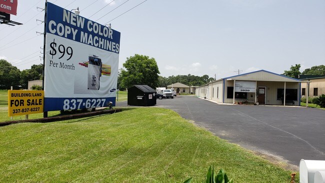
Property Record
3920 Highway 90 E, Broussard, LA 70518

Property Detail
3920 Highway 90 E
6102013
TR 2 SEC 58 T10S R5E (.732 AC)
Warehouse
Lafayette
B and X Area of moderate flood hazard, usually the area between the limits of the 100-year and 500-year floods.
Louisiana
2024
0.73 AC
2024
Outlying Lafayette Parish
001425
Lafayette
5,992 SF
Lafayette, LA
NEARBY LISTINGS FOR SALE OR LEASE
-
-
View all Broussard listings for sale on LoopNet.com
DEMOGRAPHICS near 3920 Highway 90 E
1 mile
3 mile
5 mile
2025 Total Population
4,623
23,653
69,742
2030 Population
4,846
24,788
72,893
Pop Growth 2025-2030
+ 4.82%
+ 4.80%
+ 4.52%
Average Age
39
38
39
2025 Total Households
1,913
9,469
28,183
HH Growth 2025-2030
+ 4.91%
+ 4.93%
+ 4.67%
Median Household Inc
$61,536
$69,816
$82,600
Avg Household Size
2.40
2.40
2.40
2025 Avg HH Vehicles
2.00
2.00
2.00
Median Home Value
$248,234
$272,812
$292,350
Median Year Built
1991
1999
1999
Nearby Places
Map Layers
Map Styles
 Street
 Aerial
Transit
 Traffic
 Biking
Places
Listings with unknown addresses are not visible on the map
- Restaurants
- Banks
- Shops
- Fitness
- Groceries
PUBLIC TRANSPORTATION
COMMUTER RAIL
Lafayette Amtrak Station (Sunset Limited - Amtrak)
Drive
Walk
Distance
Lafayette Amtrak Station (Sunset Limited - Amtrak)
10 min
6.7 mi
AIRPORT
Lafayette Regional/Paul Fournet Field
Drive
Walk
Distance
Lafayette Regional/Paul Fournet Field
9 min
5.7 mi
Freight Ports
Port of Iberia
Drive
Walk
Distance
Port of Iberia
23 min
17.7 mi
SALE & LEASE HISTORY
LISTING DATE
SALE/LEASE

Jul 02, 2019
For Sale
Nearby Properties
Address
Land Use
TOTAL SIZE
Lot Size
Zoning
Address
Land Use
TOTAL SIZE
Lot Size
Zoning
158,272 SF
Address
Land Use
TOTAL SIZE
Lot Size
Zoning
12.41 AC
Address
Land Use
TOTAL SIZE
Lot Size
Zoning
13.87 AC
Address
Land Use
TOTAL SIZE
Lot Size
Zoning
200,194 SF
30.80 AC
Address
Land Use
TOTAL SIZE
Lot Size
Zoning
9.02 AC
Address
Land Use
TOTAL SIZE
Lot Size
Zoning
5,625 SF
25.86 AC
Address
Land Use
TOTAL SIZE
Lot Size
Zoning
141,600 SF
24.31 AC
Address
Land Use
TOTAL SIZE
Lot Size
Zoning
69,328 SF
27.85 AC
Address
Land Use
TOTAL SIZE
Lot Size
Zoning
6.63 AC
Address
Land Use
TOTAL SIZE
Lot Size
Zoning
7,020 SF
222.16 AC
Address
Land Use
TOTAL SIZE
Lot Size
Zoning
25,886 SF
8.39 AC
Address
Land Use
TOTAL SIZE
Lot Size
Zoning
22,489 SF
6.52 AC
Address
Land Use
TOTAL SIZE
Lot Size
Zoning
1.87 AC
Address
Land Use
TOTAL SIZE
Lot Size
Zoning
283,435 SF
39.25 AC
Address
Land Use
TOTAL SIZE
Lot Size
Zoning
4,800 SF
17.84 AC
Address
Land Use
TOTAL SIZE
Lot Size
Zoning
106,776 SF
17.43 AC
Address
Land Use
TOTAL SIZE
Lot Size
Zoning
84,500 SF
15 AC
Address
Land Use
TOTAL SIZE
Lot Size
Zoning
193,255 SF
13.52 AC
Address
Land Use
TOTAL SIZE
Lot Size
Zoning
63,154 SF
6.20 AC
Address
Land Use
TOTAL SIZE
Lot Size
Zoning
Address
Land Use
TOTAL SIZE
Lot Size
Zoning
81,000 SF
20.01 AC
Address
Land Use
TOTAL SIZE
Lot Size
Zoning
23,450 SF
9.30 AC
Address
Land Use
TOTAL SIZE
Lot Size
Zoning
54,916 SF
3.81 AC
Address
Land Use
TOTAL SIZE
Lot Size
Zoning
117,821 SF
9.15 AC
Address
Land Use
TOTAL SIZE
Lot Size
Zoning
22,690 SF
5.25 AC
Address
Land Use
TOTAL SIZE
Lot Size
Zoning
52,080 SF
1.78 AC
Address
Land Use
TOTAL SIZE
Lot Size
Zoning
49,700 SF
5.50 AC
Address
Land Use
TOTAL SIZE
Lot Size
Zoning
18,592 SF
12.53 AC
Address
Land Use
TOTAL SIZE
Lot Size
Zoning
6.64 AC
Address
Land Use
TOTAL SIZE
Lot Size
Zoning
59,220 SF
9 AC
The World's #1 Commercial Real Estate Marketplace
Connect with us
© 2026 CoStar Group
The information above has been obtained from sources believed reliable. While we do not doubt its accuracy we have not verified it and make no guarantee, warranty or representation about it. It is your responsibility to independently confirm its accuracy and completeness. Any projections, opinions, assumptions, or estimates used are for example only and do not represent the current or future performance of the property. The value of this transaction to you depends on tax and other factors which should be evaluated by your tax, financial, and legal advisors. You and your advisors should conduct a careful, independent investigation of the property to determine to your satisfaction the suitability of the property for your needs.