Property Record
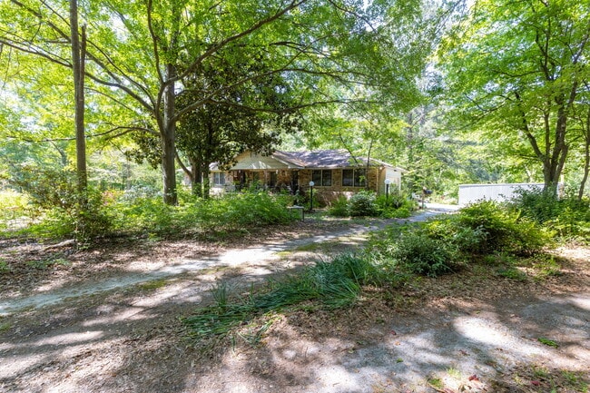
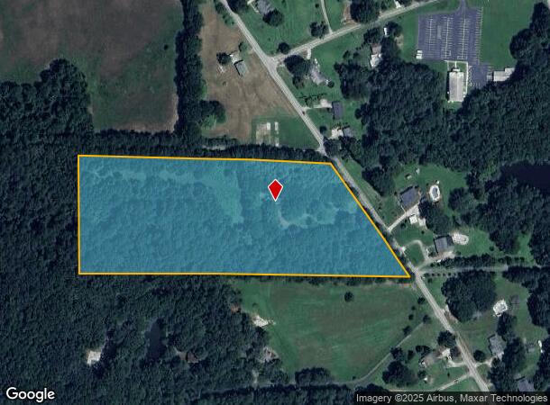
3920 Hiram Lithia Springs Rd, Powder Springs, GA 30127

This Property Is For Sale
NEARBY LISTINGS FOR SALE OR LEASE
Property Detail
3920 Hiram Lithia Springs Rd
Atlanta-Sandy Springs-Roswell, GA
Homesite
19-0894-0-005-0
Cobb
Sfr
Georgia
X
10.12 AC
13067C0176G
Douglasville/Lithia Springs
1,665 SF
Atlanta
DEMOGRAPHICS near 3920 Hiram Lithia Springs Rd
1 Mile
3 Mile
5 Mile
2024 Total Population
4,065
34,629
90,871
2029 Population
4,237
36,507
96,706
Pop Growth 2024-2029
+ 4.23%
+ 5.42%
+ 6.42%
Average Age
40
40
39
2024 Total Households
1,373
12,218
31,181
HH Growth 2024-2029
+ 4.15%
+ 5.69%
+ 6.62%
Median Household Inc
$91,697
$91,247
$89,616
Avg Household Size
2.80
2.80
2.90
2024 Avg HH Vehicles
2.00
2.00
2.00
Median Home Value
$269,979
$261,987
$259,355
Median Year Built
1992
1995
1995
Nearby Places
- Restaurants
- Banks
- Shops
- Fitness
- Groceries
PUBLIC TRANSPORTATION
AIRPORT
Hartsfield - Jackson Atlanta International
DRIVE
WALK
Distance
Hartsfield - Jackson Atlanta International
47 min
31.1 mi
Freight Ports
Georgia Ports - Savannah
DRIVE
WALK
Distance
Georgia Ports - Savannah
310 min
270.4 mi
Nearby Properties
Address
Land Use
TOTAL SIZE
Lot Size
Zoning
Address
Land Use
TOTAL SIZE
Lot Size
Zoning
18.80 AC
MXU
Address
Land Use
TOTAL SIZE
Lot Size
Zoning
9,882 SF
4.61 AC
CBD
Address
Land Use
TOTAL SIZE
Lot Size
Zoning
Address
Land Use
TOTAL SIZE
Lot Size
Zoning
15.02 AC
Address
Land Use
TOTAL SIZE
Lot Size
Zoning
171,510 SF
7.63 AC
MXU
Address
Land Use
TOTAL SIZE
Lot Size
Zoning
Address
Land Use
TOTAL SIZE
Lot Size
Zoning
350,000 SF
24 AC
HI
Address
Land Use
TOTAL SIZE
Lot Size
Zoning
21.05 AC
Address
Land Use
TOTAL SIZE
Lot Size
Zoning
141,658 SF
17.36 AC
PSC
Address
Land Use
TOTAL SIZE
Lot Size
Zoning
25.34 AC
Address
Land Use
TOTAL SIZE
Lot Size
Zoning
171,184 SF
14.63 AC
PSC
Address
Land Use
TOTAL SIZE
Lot Size
Zoning
79,348 SF
12.04 AC
CRC
Address
Land Use
TOTAL SIZE
Lot Size
Zoning
133,006 SF
15.53 AC
PSC
Address
Land Use
TOTAL SIZE
Lot Size
Zoning
12,374 SF
1.42 AC
CBD
Address
Land Use
TOTAL SIZE
Lot Size
Zoning
67,341 SF
9.07 AC
GC
Address
Land Use
TOTAL SIZE
Lot Size
Zoning
101,340 SF
4.24 AC
CRC
Address
Land Use
TOTAL SIZE
Lot Size
Zoning
104,746 SF
16.19 AC
CRC/LRO
Address
Land Use
TOTAL SIZE
Lot Size
Zoning
185,183 SF
6.99 AC
OI
Address
Land Use
TOTAL SIZE
Lot Size
Zoning
103,185 SF
13.41 AC
B2
Address
Land Use
TOTAL SIZE
Lot Size
Zoning
367,298 SF
15.38 AC
LI
Address
Land Use
TOTAL SIZE
Lot Size
Zoning
86,556 SF
8.10 AC
PSC
Address
Land Use
TOTAL SIZE
Lot Size
Zoning
109,540 SF
13.99 AC
B2
Address
Land Use
TOTAL SIZE
Lot Size
Zoning
72,580 SF
7.05 AC
LI
Address
Land Use
TOTAL SIZE
Lot Size
Zoning
56,140 SF
8.24 AC
CRC
Address
Land Use
TOTAL SIZE
Lot Size
Zoning
57,600 SF
2.91 AC
PSC
Address
Land Use
TOTAL SIZE
Lot Size
Zoning
67,875 SF
1.91 AC
MXU
Address
Land Use
TOTAL SIZE
Lot Size
Zoning
70,182 SF
7.35 AC
I1
Address
Land Use
TOTAL SIZE
Lot Size
Zoning
87,362 SF
20 AC
LI
Address
Land Use
TOTAL SIZE
Lot Size
Zoning
50,622 SF
7.89 AC
B2
The World's #1 Commercial Real Estate Marketplace
Connect with us
© 2025 CoStar Group
The information above has been obtained from sources believed reliable. While we do not doubt its accuracy we have not verified it and make no guarantee, warranty or representation about it. It is your responsibility to independently confirm its accuracy and completeness. Any projections, opinions, assumptions, or estimates used are for example only and do not represent the current or future performance of the property. The value of this transaction to you depends on tax and other factors which should be evaluated by your tax, financial, and legal advisors. You and your advisors should conduct a careful, independent investigation of the property to determine to your satisfaction the suitability of the property for your needs.