Property Record
3920 Via Real, Carpinteria, CA 93013

Property Detail
3920 Via Real
Santa Maria-Santa Barbara, CA
PUEBLO MAP 12 LOT 20
005-430-019
SANTA BARBARA
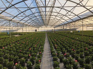
Horticulturegrowinghousesagricultural
California
AGI10
20
AO River or stream flood hazard areas, and areas with a 1% or greater chance of shallow flooding each year. These areas have a 26% chance of flooding over the life of a 30-year mortgage.
7.04 AC
2024
S Santa Barbara Coastal
2025
Santa Barbara/Sta Maria/Goleta
001706
NEARBY LISTINGS FOR SALE OR LEASE
DEMOGRAPHICS near 3920 Via Real
1 mile
3 mile
5 mile
2025 Total Population
3,147
15,814
20,791
2030 Population
3,170
15,953
20,964
Pop Growth 2025-2030
+ 0.73%
+ 0.88%
+ 0.83%
Average Age
43
43
44
2025 Total Households
1,239
6,043
8,099
HH Growth 2025-2030
+ 0.97%
+ 1.06%
+ 0.93%
Median Household Inc
$107,079
$99,966
$113,257
Avg Household Size
2.50
2.50
2.50
2025 Avg HH Vehicles
2.00
2.00
2.00
Median Home Value
$893,914
$1,052,582
$1,084,437
Median Year Built
1979
1974
1974
Nearby Places
Map Layers
Map Styles
 Street
 Aerial
Layers
 Traffic
 Biking
Places
Listings with unknown addresses are not visible on the map
- Restaurants
- Banks
- Shops
- Fitness
- Groceries
PUBLIC TRANSPORTATION
COMMUTER RAIL
Drive
Walk
Distance
5 min
1.7 mi
Drive
Walk
Distance
15 min
9.6 mi
AIRPORT
Santa Barbara Municipal
Drive
Walk
Distance
Santa Barbara Municipal
41 min
21.8 mi
Freight Ports
The Port of Hueneme
Drive
Walk
Distance
The Port of Hueneme
44 min
30.5 mi
SALE & LEASE HISTORY
LISTING DATE
SALE/LEASE

May 17, 2019
For Sale
Nearby Properties
Address
Land Use
TOTAL SIZE
Lot Size
Zoning
Address
Land Use
TOTAL SIZE
Lot Size
Zoning
Address
Land Use
TOTAL SIZE
Lot Size
Zoning
Address
Land Use
TOTAL SIZE
Lot Size
Zoning
2.68 AC
AGI5
Address
Land Use
TOTAL SIZE
Lot Size
Zoning
Address
Land Use
TOTAL SIZE
Lot Size
Zoning
14.66 AC
AGI10
Address
Land Use
TOTAL SIZE
Lot Size
Zoning
10.26 AC
3E1
Address
Land Use
TOTAL SIZE
Lot Size
Zoning
Address
Land Use
TOTAL SIZE
Lot Size
Zoning
1,368 SF
12.28 AC
AGI10
Address
Land Use
TOTAL SIZE
Lot Size
Zoning
8,010 SF
10 AC
AGI10
Address
Land Use
TOTAL SIZE
Lot Size
Zoning
Address
Land Use
TOTAL SIZE
Lot Size
Zoning
1.95 AC
Address
Land Use
TOTAL SIZE
Lot Size
Zoning
0.70 AC
Address
Land Use
TOTAL SIZE
Lot Size
Zoning
Address
Land Use
TOTAL SIZE
Lot Size
Zoning
19 AC
AGI10
Address
Land Use
TOTAL SIZE
Lot Size
Zoning
Address
Land Use
TOTAL SIZE
Lot Size
Zoning
7,657 SF
8.12 AC
AGI10
Address
Land Use
TOTAL SIZE
Lot Size
Zoning
2.69 AC
Address
Land Use
TOTAL SIZE
Lot Size
Zoning
3.64 AC
3E1
Address
Land Use
TOTAL SIZE
Lot Size
Zoning
Address
Land Use
TOTAL SIZE
Lot Size
Zoning
Address
Land Use
TOTAL SIZE
Lot Size
Zoning
3,377 SF
21.62 AC
AGI20
Address
Land Use
TOTAL SIZE
Lot Size
Zoning
1.59 AC
Address
Land Use
TOTAL SIZE
Lot Size
Zoning
56 AC
AGI40
Address
Land Use
TOTAL SIZE
Lot Size
Zoning
11.30 AC
AGI20
Address
Land Use
TOTAL SIZE
Lot Size
Zoning
6 AC
AGI10
Address
Land Use
TOTAL SIZE
Lot Size
Zoning
6.24 AC
AGI5
Address
Land Use
TOTAL SIZE
Lot Size
Zoning
2,229 SF
0.12 AC
Address
Land Use
TOTAL SIZE
Lot Size
Zoning
40.05 AC
AGI40
Address
Land Use
TOTAL SIZE
Lot Size
Zoning
1,756 SF
15.32 AC
AGI10
Address
Land Use
TOTAL SIZE
Lot Size
Zoning
28.24 AC
AGI10
The World's #1 Commercial Real Estate Marketplace
Connect with us
© 2026 CoStar Group
The information above has been obtained from sources believed reliable. While we do not doubt its accuracy we have not verified it and make no guarantee, warranty or representation about it. It is your responsibility to independently confirm its accuracy and completeness. Any projections, opinions, assumptions, or estimates used are for example only and do not represent the current or future performance of the property. The value of this transaction to you depends on tax and other factors which should be evaluated by your tax, financial, and legal advisors. You and your advisors should conduct a careful, independent investigation of the property to determine to your satisfaction the suitability of the property for your needs.