Property Record
3920 W 13Th St, Davenport, IA 52804

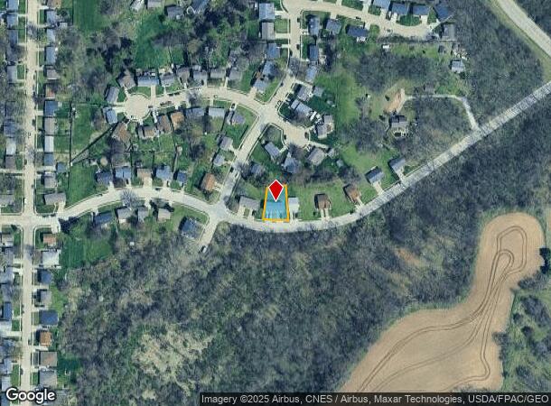
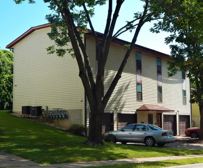
This Property Is For Sale
NEARBY LISTINGS FOR SALE OR LEASE
Property Detail
3920 W 13Th St
Davenport-Moline-Rock Island, IA-IL
Meadowbrook 7Th Add
S2923B06
MEADOWBROOK 7TH ADD LOT: 006 MEADOWBROOK 7TH ADD
Apartment
Scott
X
Iowa
19163C0345H
6
2025
0.15 AC
2025
Northwest Davenport
012502
Davenport/Moline/Rock Island
2,880 SF
DEMOGRAPHICS near 3920 W 13Th St
1 Mile
3 Mile
5 Mile
2024 Total Population
7,044
47,473
113,964
2029 Population
6,938
47,144
113,358
Pop Growth 2024-2029
(1.50%)
(0.69%)
(0.53%)
Average Age
41
39
39
2024 Total Households
3,077
19,442
47,058
HH Growth 2024-2029
(1.53%)
(0.67%)
(0.53%)
Median Household Inc
$53,838
$51,934
$52,571
Avg Household Size
2.30
2.30
2.30
2024 Avg HH Vehicles
2.00
2.00
2.00
Median Home Value
$148,992
$131,603
$136,830
Median Year Built
1969
1957
1958
Nearby Places
- Restaurants
- Banks
- Shops
- Fitness
- Groceries
PUBLIC TRANSPORTATION
AIRPORT
Quad Cities International
DRIVE
WALK
Distance
Quad Cities International
25 min
12.5 mi
Freight Ports
Port Milwaukee
DRIVE
WALK
Distance
Port Milwaukee
249 min
217.3 mi
Nearby Properties
Address
Land Use
TOTAL SIZE
Lot Size
Zoning
Address
Land Use
TOTAL SIZE
Lot Size
Zoning
3,516 SF
26.74 AC
Address
Land Use
TOTAL SIZE
Lot Size
Zoning
197,194 SF
5.14 AC
Address
Land Use
TOTAL SIZE
Lot Size
Zoning
253,608 SF
9.29 AC
Address
Land Use
TOTAL SIZE
Lot Size
Zoning
63,359 SF
12.01 AC
Address
Land Use
TOTAL SIZE
Lot Size
Zoning
352,332 SF
34.16 AC
Address
Land Use
TOTAL SIZE
Lot Size
Zoning
61,623 SF
2.18 AC
Address
Land Use
TOTAL SIZE
Lot Size
Zoning
77,187 SF
0.88 AC
Address
Land Use
TOTAL SIZE
Lot Size
Zoning
70,098 SF
9.72 AC
Address
Land Use
TOTAL SIZE
Lot Size
Zoning
104,415 SF
5.89 AC
Address
Land Use
TOTAL SIZE
Lot Size
Zoning
12,648 SF
8.28 AC
Address
Land Use
TOTAL SIZE
Lot Size
Zoning
54,644 SF
2.41 AC
Address
Land Use
TOTAL SIZE
Lot Size
Zoning
213,686 SF
23.29 AC
Address
Land Use
TOTAL SIZE
Lot Size
Zoning
3,000 SF
59.92 AC
Address
Land Use
TOTAL SIZE
Lot Size
Zoning
54,026 SF
Address
Land Use
TOTAL SIZE
Lot Size
Zoning
43,343 SF
3.56 AC
Address
Land Use
TOTAL SIZE
Lot Size
Zoning
172,527 SF
1.10 AC
Address
Land Use
TOTAL SIZE
Lot Size
Zoning
70,974 SF
13.14 AC
Address
Land Use
TOTAL SIZE
Lot Size
Zoning
43,360 SF
2.92 AC
Address
Land Use
TOTAL SIZE
Lot Size
Zoning
25,803 SF
2 AC
Address
Land Use
TOTAL SIZE
Lot Size
Zoning
3,283 SF
20 AC
Address
Land Use
TOTAL SIZE
Lot Size
Zoning
1,080 SF
16.40 AC
Address
Land Use
TOTAL SIZE
Lot Size
Zoning
12,969 SF
3.94 AC
Address
Land Use
TOTAL SIZE
Lot Size
Zoning
86,754 SF
1.11 AC
Address
Land Use
TOTAL SIZE
Lot Size
Zoning
68,808 SF
2.28 AC
Address
Land Use
TOTAL SIZE
Lot Size
Zoning
21,999 SF
22 AC
Address
Land Use
TOTAL SIZE
Lot Size
Zoning
77,870 SF
6.37 AC
Address
Land Use
TOTAL SIZE
Lot Size
Zoning
249,537 SF
44.45 AC
Address
Land Use
TOTAL SIZE
Lot Size
Zoning
329,938 SF
Address
Land Use
TOTAL SIZE
Lot Size
Zoning
10,758 SF
34.12 AC
Address
Land Use
TOTAL SIZE
Lot Size
Zoning
14,947 SF
26.21 AC
The World's #1 Commercial Real Estate Marketplace
Connect with us
© 2025 CoStar Group
The information above has been obtained from sources believed reliable. While we do not doubt its accuracy we have not verified it and make no guarantee, warranty or representation about it. It is your responsibility to independently confirm its accuracy and completeness. Any projections, opinions, assumptions, or estimates used are for example only and do not represent the current or future performance of the property. The value of this transaction to you depends on tax and other factors which should be evaluated by your tax, financial, and legal advisors. You and your advisors should conduct a careful, independent investigation of the property to determine to your satisfaction the suitability of the property for your needs.