Property Record
3920 W Roll Ave, Bloomington, IN 47403

NEARBY LISTINGS FOR SALE OR LEASE
-
-
View all Bloomington listings for sale on LoopNet.com
Property Detail
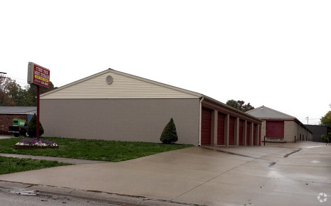
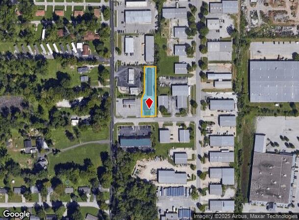
3920 W Roll Ave
Publicstorage
PT W1/2 E1/2 12-8-2W .55A
X
Monroe
18105C0139D
Indiana
2024
0.55 AC
2024
Other Market Areas
000501
Bloomington, IN
2,600 SF
53-09-12-100-004.000-016
DEMOGRAPHICS near 3920 W Roll Ave
1 Mile
3 Mile
5 Mile
2024 Total Population
5,502
36,881
96,960
2029 Population
5,455
36,837
96,673
Pop Growth 2024-2029
(0.85%)
(0.12%)
(0.30%)
Average Age
37
36
35
2024 Total Households
2,573
17,112
40,372
HH Growth 2024-2029
(0.86%)
(0.14%)
(0.31%)
Median Household Inc
$48,081
$48,718
$45,781
Avg Household Size
2.10
2.10
2.10
2024 Avg HH Vehicles
1.00
2.00
2.00
Median Home Value
$143,548
$176,145
$230,522
Median Year Built
1981
1989
1986
Nearby Places
Map Layers
Map Styles
 Street
 Aerial
- Restaurants
- Banks
- Shops
- Fitness
- Groceries
Nearby Properties
Address
Land Use
TOTAL SIZE
Lot Size
Zoning
Address
Land Use
TOTAL SIZE
Lot Size
Zoning
442,250 SF
37.15 AC
Address
Land Use
TOTAL SIZE
Lot Size
Zoning
496,556 SF
1.73 AC
Address
Land Use
TOTAL SIZE
Lot Size
Zoning
318,600 SF
43.80 AC
IL
Address
Land Use
TOTAL SIZE
Lot Size
Zoning
35,777 SF
11.68 AC
Address
Land Use
TOTAL SIZE
Lot Size
Zoning
19,128 SF
24.44 AC
Address
Land Use
TOTAL SIZE
Lot Size
Zoning
60,434 SF
29.85 AC
IG
Address
Land Use
TOTAL SIZE
Lot Size
Zoning
169,170 SF
0.72 AC
Address
Land Use
TOTAL SIZE
Lot Size
Zoning
8,190 SF
4.22 AC
Address
Land Use
TOTAL SIZE
Lot Size
Zoning
64,687 SF
9.96 AC
Address
Land Use
TOTAL SIZE
Lot Size
Zoning
134,566 SF
0.60 AC
Address
Land Use
TOTAL SIZE
Lot Size
Zoning
7,500 SF
0.40 AC
Address
Land Use
TOTAL SIZE
Lot Size
Zoning
181,798 SF
0.80 AC
Address
Land Use
TOTAL SIZE
Lot Size
Zoning
32,737 SF
0.93 AC
Address
Land Use
TOTAL SIZE
Lot Size
Zoning
18,772 SF
2.69 AC
Address
Land Use
TOTAL SIZE
Lot Size
Zoning
14,376 SF
11.03 AC
Address
Land Use
TOTAL SIZE
Lot Size
Zoning
576 SF
13 AC
Address
Land Use
TOTAL SIZE
Lot Size
Zoning
1,120 SF
11.95 AC
Address
Land Use
TOTAL SIZE
Lot Size
Zoning
87,842 SF
11.14 AC
GB
Address
Land Use
TOTAL SIZE
Lot Size
Zoning
64,798 SF
18.32 AC
RE1
Address
Land Use
TOTAL SIZE
Lot Size
Zoning
19,623 SF
8.21 AC
Address
Land Use
TOTAL SIZE
Lot Size
Zoning
119,952 SF
0.82 AC
Address
Land Use
TOTAL SIZE
Lot Size
Zoning
6,120 SF
36.03 AC
Address
Land Use
TOTAL SIZE
Lot Size
Zoning
17,950 SF
12.06 AC
Address
Land Use
TOTAL SIZE
Lot Size
Zoning
218,783 SF
24.97 AC
GB
Address
Land Use
TOTAL SIZE
Lot Size
Zoning
11,488 SF
14.33 AC
Address
Land Use
TOTAL SIZE
Lot Size
Zoning
48,022 SF
0.77 AC
Address
Land Use
TOTAL SIZE
Lot Size
Zoning
107,519 SF
0.03 AC
Address
Land Use
TOTAL SIZE
Lot Size
Zoning
64,139 SF
2.82 AC
Address
Land Use
TOTAL SIZE
Lot Size
Zoning
126,046 SF
19.03 AC
IL
Address
Land Use
TOTAL SIZE
Lot Size
Zoning
40,960 SF
11.76 AC
PUD
The World's #1 Commercial Real Estate Marketplace
Connect with us
© 2025 CoStar Group
The information above has been obtained from sources believed reliable. While we do not doubt its accuracy we have not verified it and make no guarantee, warranty or representation about it. It is your responsibility to independently confirm its accuracy and completeness. Any projections, opinions, assumptions, or estimates used are for example only and do not represent the current or future performance of the property. The value of this transaction to you depends on tax and other factors which should be evaluated by your tax, financial, and legal advisors. You and your advisors should conduct a careful, independent investigation of the property to determine to your satisfaction the suitability of the property for your needs.