Property Record
39207 Magnetics Blvd, Wadsworth, IL 60083


NEARBY LISTINGS FOR SALE OR LEASE
-
-
View all Wadsworth listings for sale on LoopNet.com
Property Detail
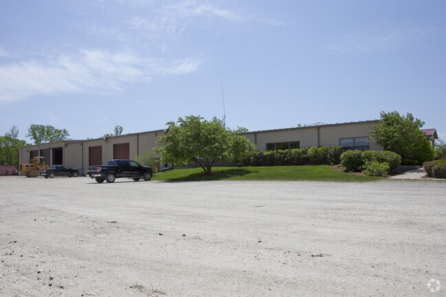
39207 Magnetics Blvd
03-27-400-043
Pt Sw
Commercialbuilding
PT SW1/4 SE1/4; BEG X OF NLN SD QUARTER SEC AND WLN RR R OW, W 730, S 240, E 730, N 240 TO POB SECTION 27 TOWNSHIP 46 RANGE 11
AE
Lake
17097C0066L
Illinois
2023
4.02 AC
2024
Far North
866000
Chicago
15,600 SF
Chicago-Naperville-Elgin, IL-IN
DEMOGRAPHICS near 39207 Magnetics Blvd
1 Mile
3 Mile
5 Mile
2024 Total Population
710
13,816
90,831
2029 Population
684
13,483
89,637
Pop Growth 2024-2029
(3.66%)
(2.41%)
(1.31%)
Average Age
46
40
38
2024 Total Households
273
5,084
32,265
HH Growth 2024-2029
(3.66%)
(2.52%)
(1.46%)
Median Household Inc
$107,143
$96,938
$80,610
Avg Household Size
2.60
2.70
2.80
2024 Avg HH Vehicles
2.00
2.00
2.00
Median Home Value
$360,897
$265,356
$221,866
Median Year Built
1982
1994
1984
Nearby Places
Map Layers
Map Styles
 Street
 Aerial
- Restaurants
- Banks
- Shops
- Fitness
- Groceries
PUBLIC TRANSPORTATION
COMMUTER RAIL
Zion Station (Union Pacific North Line - Northeast Illinois Regional Commuter Railroad (Metra))
DRIVE
WALK
Distance
Zion Station (Union Pacific North Line - Northeast Illinois Regional Commuter Railroad (Metra))
18 min
8.2 mi
Waukegan Station (Union Pacific North Line - Northeast Illinois Regional Commuter Railroad (Metra))
DRIVE
WALK
Distance
Waukegan Station (Union Pacific North Line - Northeast Illinois Regional Commuter Railroad (Metra))
18 min
9.7 mi
AIRPORT
Chicago O'Hare International
DRIVE
WALK
Distance
Chicago O'Hare International
71 min
41.8 mi
Freight Ports
Port Milwaukee
DRIVE
WALK
Distance
Port Milwaukee
51 min
42.3 mi
Nearby Properties
Address
Land Use
TOTAL SIZE
Lot Size
Zoning
Address
Land Use
TOTAL SIZE
Lot Size
Zoning
914,522 SF
7.81 AC
Address
Land Use
TOTAL SIZE
Lot Size
Zoning
218,500 SF
9.86 AC
Address
Land Use
TOTAL SIZE
Lot Size
Zoning
122,314 SF
5.95 AC
Address
Land Use
TOTAL SIZE
Lot Size
Zoning
1,148,346 SF
7.90 AC
Address
Land Use
TOTAL SIZE
Lot Size
Zoning
218,500 SF
10.46 AC
Address
Land Use
TOTAL SIZE
Lot Size
Zoning
83,996 SF
4.80 AC
Address
Land Use
TOTAL SIZE
Lot Size
Zoning
64,860 SF
7.59 AC
Address
Land Use
TOTAL SIZE
Lot Size
Zoning
112,836 SF
5.85 AC
Address
Land Use
TOTAL SIZE
Lot Size
Zoning
66,501 SF
3.19 AC
Address
Land Use
TOTAL SIZE
Lot Size
Zoning
89,770 SF
4.13 AC
Address
Land Use
TOTAL SIZE
Lot Size
Zoning
7,450 SF
21.35 AC
Address
Land Use
TOTAL SIZE
Lot Size
Zoning
55,868 SF
3.48 AC
Address
Land Use
TOTAL SIZE
Lot Size
Zoning
66,522 SF
5.15 AC
Address
Land Use
TOTAL SIZE
Lot Size
Zoning
34,060 SF
11.41 AC
Address
Land Use
TOTAL SIZE
Lot Size
Zoning
41,760 SF
1.78 AC
Address
Land Use
TOTAL SIZE
Lot Size
Zoning
41,760 SF
1.37 AC
Address
Land Use
TOTAL SIZE
Lot Size
Zoning
67,400 SF
5.78 AC
Address
Land Use
TOTAL SIZE
Lot Size
Zoning
2,746 SF
29.16 AC
Address
Land Use
TOTAL SIZE
Lot Size
Zoning
41,161 SF
608.77 AC
Address
Land Use
TOTAL SIZE
Lot Size
Zoning
23,114 SF
6.23 AC
Address
Land Use
TOTAL SIZE
Lot Size
Zoning
30,615 SF
5.71 AC
Address
Land Use
TOTAL SIZE
Lot Size
Zoning
34,106 SF
0.88 AC
Address
Land Use
TOTAL SIZE
Lot Size
Zoning
31,344 SF
2.13 AC
Address
Land Use
TOTAL SIZE
Lot Size
Zoning
7,940 SF
10 AC
Address
Land Use
TOTAL SIZE
Lot Size
Zoning
32,202 SF
1.01 AC
Address
Land Use
TOTAL SIZE
Lot Size
Zoning
32,202 SF
0.95 AC
Address
Land Use
TOTAL SIZE
Lot Size
Zoning
36,913 SF
1.47 AC
Address
Land Use
TOTAL SIZE
Lot Size
Zoning
46,874 SF
2.14 AC
Address
Land Use
TOTAL SIZE
Lot Size
Zoning
41,078 SF
12.08 AC
Address
Land Use
TOTAL SIZE
Lot Size
Zoning
40,404 SF
3 AC
The World's #1 Commercial Real Estate Marketplace
Connect with us
© 2026 CoStar Group
The information above has been obtained from sources believed reliable. While we do not doubt its accuracy we have not verified it and make no guarantee, warranty or representation about it. It is your responsibility to independently confirm its accuracy and completeness. Any projections, opinions, assumptions, or estimates used are for example only and do not represent the current or future performance of the property. The value of this transaction to you depends on tax and other factors which should be evaluated by your tax, financial, and legal advisors. You and your advisors should conduct a careful, independent investigation of the property to determine to your satisfaction the suitability of the property for your needs.