Property Record
39209 6 Mile Rd, Livonia, MI 48152
Current Lease Availabilities
NEARBY LISTINGS FOR SALE OR LEASE
Property Detail
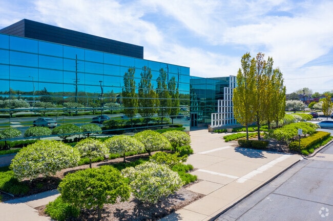
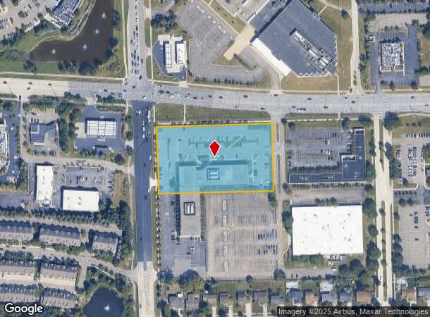
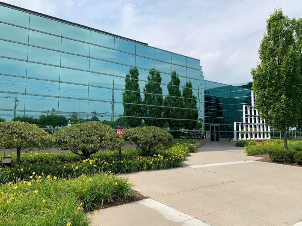
39209 6 Mile Rd
46-070-99-0001-016
COMM AT NW COR SEC 18 T1S R9E TH S 00D 11M 58S E 60.00 FT TH S 89D 45M 13S E 60.00 FT TO POB CONT TH S 89D 45M 13S E 470.00 FT TH S 00D 11M 58S E 270.00 FT TH N 89D 45M 13S W 276.41 FT TH S 00D 11M 58S E 380.02 FT TH N 89D 45M 13S W 193.59 FT TH N 00
Officebuilding
Wayne
X
Michigan
26163C0045E
0001
2024
4.82 AC
2025
Southern I-275 Corridor
557600
Detroit
80,388 SF
Detroit-Warren-Dearborn, MI
DEMOGRAPHICS near 39209 6 Mile Rd
1 Mile
3 Mile
5 Mile
2024 Total Population
7,000
60,177
190,557
2029 Population
6,766
57,946
184,238
Pop Growth 2024-2029
(3.34%)
(3.71%)
(3.32%)
Average Age
50
45
43
2024 Total Households
3,069
25,472
81,589
HH Growth 2024-2029
(3.00%)
(3.59%)
(3.28%)
Median Household Inc
$101,190
$106,061
$96,977
Avg Household Size
2.20
2.30
2.30
2024 Avg HH Vehicles
2.00
2.00
2.00
Median Home Value
$343,049
$317,455
$299,546
Median Year Built
1986
1976
1975
Nearby Places
- Restaurants
- Banks
- Shops
- Fitness
- Groceries
PUBLIC TRANSPORTATION
AIRPORT
Detroit Metro Wayne County
DRIVE
WALK
Distance
Detroit Metro Wayne County
24 min
20.0 mi
Windsor International
DRIVE
WALK
Distance
Windsor International
51 min
34.2 mi
Freight Ports
Port of Toledo
DRIVE
WALK
Distance
Port of Toledo
74 min
61.7 mi
Nearby Properties
Address
Land Use
TOTAL SIZE
Lot Size
Zoning
Address
Land Use
TOTAL SIZE
Lot Size
Zoning
1,005,040 SF
Address
Land Use
TOTAL SIZE
Lot Size
Zoning
234,403 SF
74.21 AC
OS
Address
Land Use
TOTAL SIZE
Lot Size
Zoning
250,699 SF
16.89 AC
SH
Address
Land Use
TOTAL SIZE
Lot Size
Zoning
182,121 SF
10.85 AC
HPUD
Address
Land Use
TOTAL SIZE
Lot Size
Zoning
517,265 SF
116.72 AC
Address
Land Use
TOTAL SIZE
Lot Size
Zoning
102,878 SF
10.48 AC
CJ
Address
Land Use
TOTAL SIZE
Lot Size
Zoning
192,478 SF
IND
Address
Land Use
TOTAL SIZE
Lot Size
Zoning
289,722 SF
7.34 AC
C-2
Address
Land Use
TOTAL SIZE
Lot Size
Zoning
334,346 SF
55.65 AC
TAR
Address
Land Use
TOTAL SIZE
Lot Size
Zoning
30.32 AC
RM-1
Address
Land Use
TOTAL SIZE
Lot Size
Zoning
5,339 SF
20.10 AC
R-3
Address
Land Use
TOTAL SIZE
Lot Size
Zoning
361,807 SF
18.77 AC
M-2
Address
Land Use
TOTAL SIZE
Lot Size
Zoning
730,656 SF
13.73 AC
C-4
Address
Land Use
TOTAL SIZE
Lot Size
Zoning
206,496 SF
12.72 AC
PO
Address
Land Use
TOTAL SIZE
Lot Size
Zoning
283,710 SF
IND
Address
Land Use
TOTAL SIZE
Lot Size
Zoning
80,574 SF
19.95 AC
7MIPUD
Address
Land Use
TOTAL SIZE
Lot Size
Zoning
9,706 SF
40.41 AC
RM-1
Address
Land Use
TOTAL SIZE
Lot Size
Zoning
221,508 SF
26.03 AC
IND
Address
Land Use
TOTAL SIZE
Lot Size
Zoning
113,292 SF
15.79 AC
IND
Address
Land Use
TOTAL SIZE
Lot Size
Zoning
129,448 SF
9.37 AC
OSC
Address
Land Use
TOTAL SIZE
Lot Size
Zoning
46.60 AC
R-3
Address
Land Use
TOTAL SIZE
Lot Size
Zoning
78,164 SF
5.51 AC
PUD
Address
Land Use
TOTAL SIZE
Lot Size
Zoning
66,109 SF
35.02 AC
PO
Address
Land Use
TOTAL SIZE
Lot Size
Zoning
976 SF
26.85 AC
RM-1
Address
Land Use
TOTAL SIZE
Lot Size
Zoning
Address
Land Use
TOTAL SIZE
Lot Size
Zoning
152,414 SF
13.91 AC
RM-1
Address
Land Use
TOTAL SIZE
Lot Size
Zoning
16.54 AC
RM-1
Address
Land Use
TOTAL SIZE
Lot Size
Zoning
172,094 SF
11.84 AC
M-2
Address
Land Use
TOTAL SIZE
Lot Size
Zoning
237,049 SF
27.23 AC
B-3
Address
Land Use
TOTAL SIZE
Lot Size
Zoning
19.68 AC
RM-1
The World's #1 Commercial Real Estate Marketplace
Connect with us
© 2025 CoStar Group
The information above has been obtained from sources believed reliable. While we do not doubt its accuracy we have not verified it and make no guarantee, warranty or representation about it. It is your responsibility to independently confirm its accuracy and completeness. Any projections, opinions, assumptions, or estimates used are for example only and do not represent the current or future performance of the property. The value of this transaction to you depends on tax and other factors which should be evaluated by your tax, financial, and legal advisors. You and your advisors should conduct a careful, independent investigation of the property to determine to your satisfaction the suitability of the property for your needs.