Property Record
3921 E Centre Ave, Portage, MI 49002
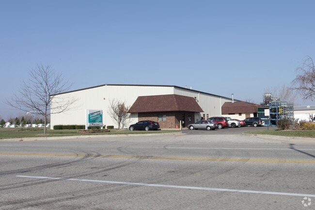

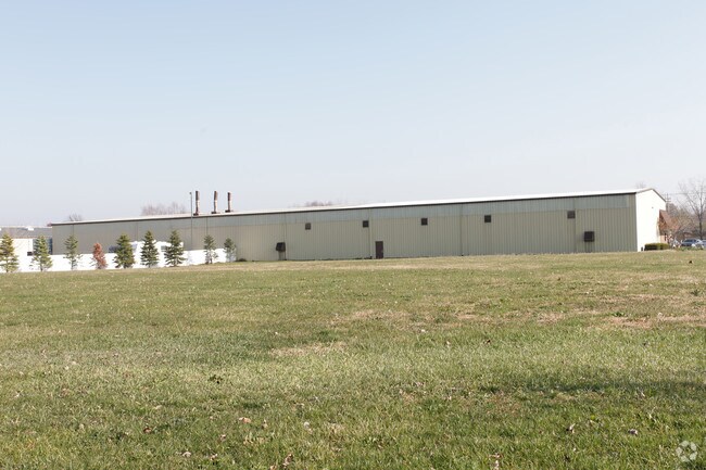
Property Detail
3921 E Centre Ave
10-00013-076-B
SECTION 13-3-11 COM AT S QTR CORNER OF SD SEC, TH W 233 FT , TH N 50 FT TO POB, TH W ON THE N ROW OF CENTRE AVE 196 FT, TH N
Industrialgeneral
Kalamazoo
I-1
Michigan
B and X Area of moderate flood hazard, usually the area between the limits of the 100-year and 500-year floods.
1.43 AC
2025
Southern Kalamazoo County
2025
West Michigan
001905
Kalamazoo-Portage, MI
NEARBY LISTINGS FOR SALE OR LEASE
DEMOGRAPHICS near 3921 E Centre Ave
1 mile
3 mile
5 mile
2025 Total Population
1,917
19,163
64,787
2030 Population
1,921
19,154
64,506
Pop Growth 2025-2030
+ 0.21%
(0.05%)
(0.43%)
Average Age
41
42
40
2025 Total Households
695
8,312
27,124
HH Growth 2025-2030
0.00%
(0.30%)
(0.62%)
Median Household Inc
$127,739
$71,267
$72,433
Avg Household Size
2.60
2.20
2.30
2025 Avg HH Vehicles
2.00
2.00
2.00
Median Home Value
$360,880
$246,863
$245,349
Median Year Built
1976
1972
1970
Nearby Places
Map Layers
Map Styles
 Street
 Aerial
Transit
 Traffic
 Biking
Places
Listings with unknown addresses are not visible on the map
- Restaurants
- Banks
- Shops
- Fitness
- Groceries
PUBLIC TRANSPORTATION
COMMUTER RAIL
Drive
Walk
Distance
15 min
8.0 mi
AIRPORT
Kalamazoo/Battle Creek International
Drive
Walk
Distance
Kalamazoo/Battle Creek International
13 min
4.6 mi
Nearby Properties
Address
Land Use
TOTAL SIZE
Lot Size
Zoning
Address
Land Use
TOTAL SIZE
Lot Size
Zoning
435.98 AC
I-2
Address
Land Use
TOTAL SIZE
Lot Size
Zoning
Address
Land Use
TOTAL SIZE
Lot Size
Zoning
Address
Land Use
TOTAL SIZE
Lot Size
Zoning
82,520 SF
39.35 AC
I-1
Address
Land Use
TOTAL SIZE
Lot Size
Zoning
35,119 SF
50.85 AC
RM-1
Address
Land Use
TOTAL SIZE
Lot Size
Zoning
78.75 AC
I-2
Address
Land Use
TOTAL SIZE
Lot Size
Zoning
Address
Land Use
TOTAL SIZE
Lot Size
Zoning
Address
Land Use
TOTAL SIZE
Lot Size
Zoning
Address
Land Use
TOTAL SIZE
Lot Size
Zoning
37.40 AC
I-2
Address
Land Use
TOTAL SIZE
Lot Size
Zoning
61.61 AC
Address
Land Use
TOTAL SIZE
Lot Size
Zoning
19.39 AC
OTR
Address
Land Use
TOTAL SIZE
Lot Size
Zoning
383,638 SF
25.85 AC
B-2
Address
Land Use
TOTAL SIZE
Lot Size
Zoning
37.40 AC
I-2
Address
Land Use
TOTAL SIZE
Lot Size
Zoning
17,858 SF
15.27 AC
RM-1
Address
Land Use
TOTAL SIZE
Lot Size
Zoning
18.57 AC
Address
Land Use
TOTAL SIZE
Lot Size
Zoning
202,798 SF
17.67 AC
I-1
Address
Land Use
TOTAL SIZE
Lot Size
Zoning
Address
Land Use
TOTAL SIZE
Lot Size
Zoning
28.49 AC
I-2
Address
Land Use
TOTAL SIZE
Lot Size
Zoning
291,184 SF
26.35 AC
I-1
Address
Land Use
TOTAL SIZE
Lot Size
Zoning
80,064 SF
6.13 AC
M-1
Address
Land Use
TOTAL SIZE
Lot Size
Zoning
13.77 AC
B-2
Address
Land Use
TOTAL SIZE
Lot Size
Zoning
31.79 AC
I-1
Address
Land Use
TOTAL SIZE
Lot Size
Zoning
129,350 SF
42.30 AC
I-1
Address
Land Use
TOTAL SIZE
Lot Size
Zoning
104,366 SF
9.76 AC
B-3
Address
Land Use
TOTAL SIZE
Lot Size
Zoning
7.36 AC
B-2
Address
Land Use
TOTAL SIZE
Lot Size
Zoning
20,760 SF
12.86 AC
RM-1
Address
Land Use
TOTAL SIZE
Lot Size
Zoning
10.04 AC
I-1
Address
Land Use
TOTAL SIZE
Lot Size
Zoning
103,007 SF
8.02 AC
B-2
Address
Land Use
TOTAL SIZE
Lot Size
Zoning
29,341 SF
5.72 AC
B-2
The World's #1 Commercial Real Estate Marketplace
Connect with us
© 2026 CoStar Group
The information above has been obtained from sources believed reliable. While we do not doubt its accuracy we have not verified it and make no guarantee, warranty or representation about it. It is your responsibility to independently confirm its accuracy and completeness. Any projections, opinions, assumptions, or estimates used are for example only and do not represent the current or future performance of the property. The value of this transaction to you depends on tax and other factors which should be evaluated by your tax, financial, and legal advisors. You and your advisors should conduct a careful, independent investigation of the property to determine to your satisfaction the suitability of the property for your needs.