Property Record
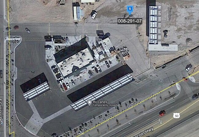
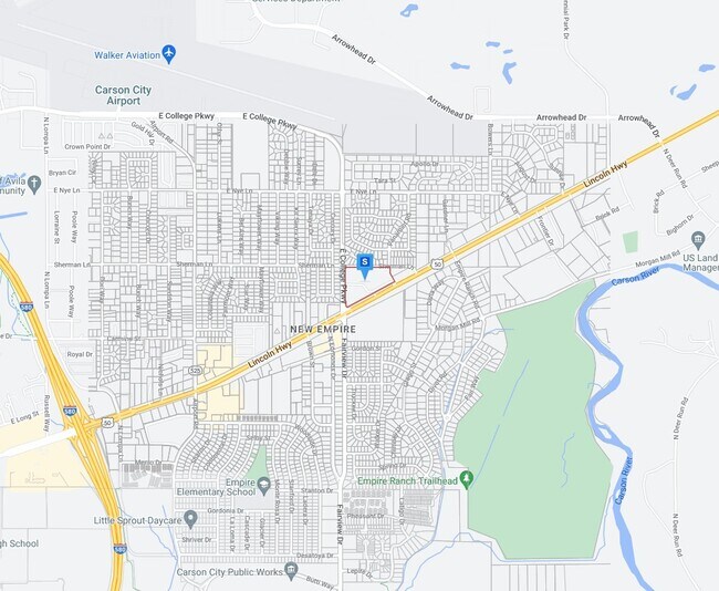
3922 Highway 50 E, Carson City, NV 89701

Property Detail
3922 Highway 50 E
008-291-05
ADJ 1, R/S 2995 (509247), BLA # 509246
Storemultistory
CARSON CITY
GC
Nevada
B and X Area of moderate flood hazard, usually the area between the limits of the 100-year and 500-year floods.
5.49 AC
2025
Carson City County
2025
Reno/Sparks
000900
Carson City, NV
6,002 SF
NEARBY LISTINGS FOR SALE OR LEASE
DEMOGRAPHICS near 3922 Highway 50 E
1 mile
3 mile
5 mile
2025 Total Population
11,422
39,694
57,909
2030 Population
11,310
39,533
57,748
Pop Growth 2025-2030
(0.98%)
(0.41%)
(0.28%)
Average Age
40
42
43
2025 Total Households
4,276
16,059
23,388
HH Growth 2025-2030
(1.29%)
(0.46%)
(0.29%)
Median Household Inc
$61,457
$65,889
$70,283
Avg Household Size
2.60
2.30
2.30
2025 Avg HH Vehicles
2.00
2.00
2.00
Median Home Value
$334,056
$406,335
$441,025
Median Year Built
1978
1980
1981
Nearby Places
Map Layers
Map Styles
 Street
 Aerial
Layers
 Traffic
 Biking
Places
Listings with unknown addresses are not visible on the map
- Restaurants
- Banks
- Shops
- Fitness
- Groceries
PUBLIC TRANSPORTATION
AIRPORT
Reno/Tahoe International
Drive
Walk
Distance
Reno/Tahoe International
53 min
32.3 mi
Nearby Properties
Address
Land Use
TOTAL SIZE
Lot Size
Zoning
Address
Land Use
TOTAL SIZE
Lot Size
Zoning
428,691 SF
10.40 AC
P
Address
Land Use
TOTAL SIZE
Lot Size
Zoning
356,776 SF
64.42 AC
P
Address
Land Use
TOTAL SIZE
Lot Size
Zoning
175,233 SF
5.88 AC
PR
Address
Land Use
TOTAL SIZE
Lot Size
Zoning
7,419 SF
0.71 AC
PR
Address
Land Use
TOTAL SIZE
Lot Size
Zoning
272,519 SF
102.35 AC
P
Address
Land Use
TOTAL SIZE
Lot Size
Zoning
144,231 SF
25.73 AC
P
Address
Land Use
TOTAL SIZE
Lot Size
Zoning
3,120 SF
6.12 AC
NB
Address
Land Use
TOTAL SIZE
Lot Size
Zoning
92,560 SF
4.93 AC
MFA
Address
Land Use
TOTAL SIZE
Lot Size
Zoning
96,057 SF
10 AC
LI
Address
Land Use
TOTAL SIZE
Lot Size
Zoning
213,246 SF
19.48 AC
GC-RC
Address
Land Use
TOTAL SIZE
Lot Size
Zoning
240 AC
PR
Address
Land Use
TOTAL SIZE
Lot Size
Zoning
157,914 SF
7.15 AC
PR
Address
Land Use
TOTAL SIZE
Lot Size
Zoning
137,022 SF
5.29 AC
RC
Address
Land Use
TOTAL SIZE
Lot Size
Zoning
109,200 SF
9.35 AC
GC
Address
Land Use
TOTAL SIZE
Lot Size
Zoning
89,408 SF
39.22 AC
P
Address
Land Use
TOTAL SIZE
Lot Size
Zoning
169,086 SF
18.49 AC
RC-P
Address
Land Use
TOTAL SIZE
Lot Size
Zoning
29.98 AC
PC
Address
Land Use
TOTAL SIZE
Lot Size
Zoning
116,494 SF
16.39 AC
P
Address
Land Use
TOTAL SIZE
Lot Size
Zoning
375 SF
520 AC
PR
Address
Land Use
TOTAL SIZE
Lot Size
Zoning
87,992 SF
4.13 AC
P
Address
Land Use
TOTAL SIZE
Lot Size
Zoning
138,001 SF
2.20 AC
P
Address
Land Use
TOTAL SIZE
Lot Size
Zoning
178.40 AC
PR
Address
Land Use
TOTAL SIZE
Lot Size
Zoning
75,863 SF
3.92 AC
RC
Address
Land Use
TOTAL SIZE
Lot Size
Zoning
111,950 SF
18.20 AC
RC-MHP
Address
Land Use
TOTAL SIZE
Lot Size
Zoning
113,007 SF
52.90 AC
PR
Address
Land Use
TOTAL SIZE
Lot Size
Zoning
4,685 SF
49.08 AC
PR
Address
Land Use
TOTAL SIZE
Lot Size
Zoning
156,408 SF
2.08 AC
MFA-GC
Address
Land Use
TOTAL SIZE
Lot Size
Zoning
160 AC
PR
Address
Land Use
TOTAL SIZE
Lot Size
Zoning
125,780 SF
28.21 AC
P
Address
Land Use
TOTAL SIZE
Lot Size
Zoning
160,769 SF
15 AC
LI
The World's #1 Commercial Real Estate Marketplace
Connect with us
© 2026 CoStar Group
The information above has been obtained from sources believed reliable. While we do not doubt its accuracy we have not verified it and make no guarantee, warranty or representation about it. It is your responsibility to independently confirm its accuracy and completeness. Any projections, opinions, assumptions, or estimates used are for example only and do not represent the current or future performance of the property. The value of this transaction to you depends on tax and other factors which should be evaluated by your tax, financial, and legal advisors. You and your advisors should conduct a careful, independent investigation of the property to determine to your satisfaction the suitability of the property for your needs.