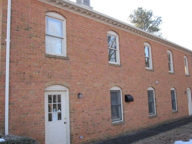
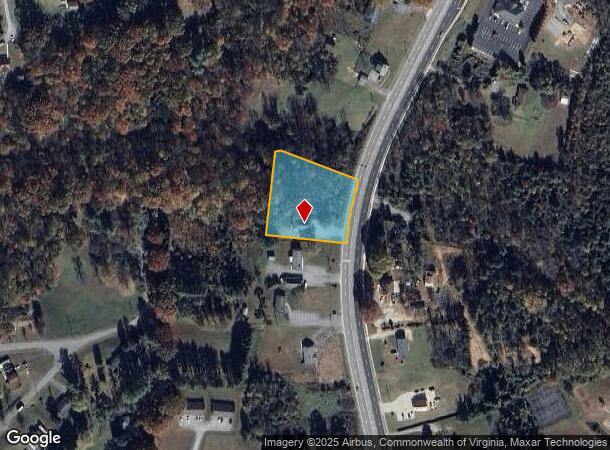
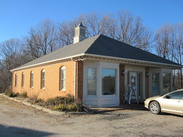
Property Record
3922 S Amherst Hwy, Madison Heights, VA 24572
NEARBY LISTINGS FOR SALE OR LEASE
Property Detail
3922 S Amherst Hwy
Lynchburg, VA
Property Surveyed For Parcle A And B For
147-A-146A
PARCEL A & PARCEL B PART OF LOTS 9,10 & 11 147 A 146A
Officebuilding
Amherst
X
Virginia
51011C0075D
9,10&11
2024
1.12 AC
2025
Lynchburg
010402
Other Market Areas
1,708 SF
DEMOGRAPHICS near 3922 S Amherst Hwy
1 Mile
3 Mile
5 Mile
2024 Total Population
2,114
11,956
36,335
2029 Population
2,137
12,129
36,865
Pop Growth 2024-2029
+ 1.09%
+ 1.45%
+ 1.46%
Average Age
43
42
40
2024 Total Households
888
4,959
15,428
HH Growth 2024-2029
+ 1.01%
+ 1.49%
+ 1.53%
Median Household Inc
$57,092
$56,409
$52,559
Avg Household Size
2.40
2.40
2.30
2024 Avg HH Vehicles
2.00
2.00
2.00
Median Home Value
$161,199
$158,772
$168,781
Median Year Built
1970
1974
1964
Nearby Places
Map Layers
Map Styles
 Street
 Aerial
- Restaurants
- Banks
- Shops
- Fitness
- Groceries
PUBLIC TRANSPORTATION
COMMUTER RAIL
DRIVE
WALK
Distance
11 min
6.6 mi
AIRPORT
Lynchburg Regional/Preston Glenn Field
DRIVE
WALK
Distance
Lynchburg Regional/Preston Glenn Field
22 min
13.9 mi
Nearby Properties
Address
Land Use
TOTAL SIZE
Lot Size
Zoning
Address
Land Use
TOTAL SIZE
Lot Size
Zoning
21,542 SF
41.78 AC
R2
Address
Land Use
TOTAL SIZE
Lot Size
Zoning
66,832 SF
48.77 AC
B2
Address
Land Use
TOTAL SIZE
Lot Size
Zoning
134,387 SF
12.17 AC
B2
Address
Land Use
TOTAL SIZE
Lot Size
Zoning
9.79 AC
B2
Address
Land Use
TOTAL SIZE
Lot Size
Zoning
61,415 SF
24.11 AC
P1
Address
Land Use
TOTAL SIZE
Lot Size
Zoning
154,922 SF
16.89 AC
B2
Address
Land Use
TOTAL SIZE
Lot Size
Zoning
128,488 SF
15.60 AC
B2
Address
Land Use
TOTAL SIZE
Lot Size
Zoning
30,537 SF
5.91 AC
B2
Address
Land Use
TOTAL SIZE
Lot Size
Zoning
149,422 SF
6.98 AC
M1
Address
Land Use
TOTAL SIZE
Lot Size
Zoning
60,545 SF
16.33 AC
B2
Address
Land Use
TOTAL SIZE
Lot Size
Zoning
40,395 SF
2.82 AC
P1
Address
Land Use
TOTAL SIZE
Lot Size
Zoning
23,793 SF
6.20 AC
B2
Address
Land Use
TOTAL SIZE
Lot Size
Zoning
100,000 SF
12.19 AC
M1
Address
Land Use
TOTAL SIZE
Lot Size
Zoning
111,468 SF
11.59 AC
M1
Address
Land Use
TOTAL SIZE
Lot Size
Zoning
19,786 SF
20 AC
R3
Address
Land Use
TOTAL SIZE
Lot Size
Zoning
8,772 SF
6.67 AC
R2
Address
Land Use
TOTAL SIZE
Lot Size
Zoning
17,160 SF
1.14 AC
B2
Address
Land Use
TOTAL SIZE
Lot Size
Zoning
70,422 SF
13.95 AC
M1
Address
Land Use
TOTAL SIZE
Lot Size
Zoning
50,000 SF
14.85 AC
M1
Address
Land Use
TOTAL SIZE
Lot Size
Zoning
1,000 SF
1.76 AC
B2
Address
Land Use
TOTAL SIZE
Lot Size
Zoning
27,960 SF
20.49 AC
B2
Address
Land Use
TOTAL SIZE
Lot Size
Zoning
19,900 SF
2.48 AC
B2
The World's #1 Commercial Real Estate Marketplace
Connect with us
© 2025 CoStar Group
The information above has been obtained from sources believed reliable. While we do not doubt its accuracy we have not verified it and make no guarantee, warranty or representation about it. It is your responsibility to independently confirm its accuracy and completeness. Any projections, opinions, assumptions, or estimates used are for example only and do not represent the current or future performance of the property. The value of this transaction to you depends on tax and other factors which should be evaluated by your tax, financial, and legal advisors. You and your advisors should conduct a careful, independent investigation of the property to determine to your satisfaction the suitability of the property for your needs.