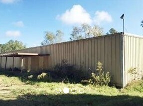
Property Record
3925 Highway 190 W, Hammond, LA 70401

NEARBY LISTINGS FOR SALE OR LEASE
Property Detail
3925 Highway 190 W
02082802
67.96A IN SEC 28 T6SR7E B245 P659 B247 P516 B296 P187 B652 P627-629 -879 B654 P451 B652 P645 B674 P516 B676 P745 B708 P840 B7
Commercialnec
Tangipahoa
A
Louisiana
22063C0300E
67.96 AC
2024
Louisiana South Area
2024
Other Market Areas
954103
Hammond, LA
491,200 SF
DEMOGRAPHICS near 3925 Highway 190 W
1 Mile
3 Mile
5 Mile
2024 Total Population
1,062
26,271
57,726
2029 Population
1,141
28,388
62,386
Pop Growth 2024-2029
+ 7.44%
+ 8.06%
+ 8.07%
Average Age
38
36
37
2024 Total Households
424
9,908
22,254
HH Growth 2024-2029
+ 7.55%
+ 8.16%
+ 8.13%
Median Household Inc
$37,616
$44,068
$52,205
Avg Household Size
2.50
2.40
2.40
2024 Avg HH Vehicles
2.00
2.00
2.00
Median Home Value
$169,117
$187,823
$195,543
Median Year Built
1985
1988
1991
Nearby Places
Map Layers
Map Styles
 Street
 Aerial
- Restaurants
- Banks
- Shops
- Fitness
- Groceries
PUBLIC TRANSPORTATION
COMMUTER RAIL
Hammond Amtrak Station (City of New Orleans - Amtrak)
DRIVE
WALK
Distance
Hammond Amtrak Station (City of New Orleans - Amtrak)
10 min
3.7 mi
Freight Ports
Port of Greater Baton Rouge
DRIVE
WALK
Distance
Port of Greater Baton Rouge
61 min
46.2 mi
SALE & LEASE HISTORY
LISTING DATE
SALE/LEASE

Oct 12, 2020
For Sale
Nearby Properties
Address
Land Use
TOTAL SIZE
Lot Size
Zoning
Address
Land Use
TOTAL SIZE
Lot Size
Zoning
Address
Land Use
TOTAL SIZE
Lot Size
Zoning
154,391 SF
12.30 AC
Address
Land Use
TOTAL SIZE
Lot Size
Zoning
Address
Land Use
TOTAL SIZE
Lot Size
Zoning
1.74 AC
Address
Land Use
TOTAL SIZE
Lot Size
Zoning
432 SF
14.80 AC
Address
Land Use
TOTAL SIZE
Lot Size
Zoning
0.89 AC
Address
Land Use
TOTAL SIZE
Lot Size
Zoning
199,026 SF
33 AC
Address
Land Use
TOTAL SIZE
Lot Size
Zoning
135,524 SF
31.08 AC
Address
Land Use
TOTAL SIZE
Lot Size
Zoning
31,920 SF
23.68 AC
Address
Land Use
TOTAL SIZE
Lot Size
Zoning
80,506 SF
13.56 AC
Address
Land Use
TOTAL SIZE
Lot Size
Zoning
96,994 SF
4.21 AC
Address
Land Use
TOTAL SIZE
Lot Size
Zoning
4,664 SF
8.14 AC
Address
Land Use
TOTAL SIZE
Lot Size
Zoning
19,624 SF
4.66 AC
Address
Land Use
TOTAL SIZE
Lot Size
Zoning
19,845 SF
10 AC
Address
Land Use
TOTAL SIZE
Lot Size
Zoning
1.99 AC
Address
Land Use
TOTAL SIZE
Lot Size
Zoning
84,150 SF
5.47 AC
Address
Land Use
TOTAL SIZE
Lot Size
Zoning
14,738 SF
2.02 AC
Address
Land Use
TOTAL SIZE
Lot Size
Zoning
28,098 SF
4.61 AC
Address
Land Use
TOTAL SIZE
Lot Size
Zoning
61,230 SF
9.79 AC
Address
Land Use
TOTAL SIZE
Lot Size
Zoning
50,000 SF
5.78 AC
Address
Land Use
TOTAL SIZE
Lot Size
Zoning
41,857 SF
16 AC
Address
Land Use
TOTAL SIZE
Lot Size
Zoning
104,140 SF
7.20 AC
Address
Land Use
TOTAL SIZE
Lot Size
Zoning
13,670 SF
5.95 AC
Address
Land Use
TOTAL SIZE
Lot Size
Zoning
49,410 SF
2.48 AC
Address
Land Use
TOTAL SIZE
Lot Size
Zoning
15,636 SF
5.15 AC
Address
Land Use
TOTAL SIZE
Lot Size
Zoning
45.86 AC
Address
Land Use
TOTAL SIZE
Lot Size
Zoning
33,506 SF
4.20 AC
Address
Land Use
TOTAL SIZE
Lot Size
Zoning
22,062 SF
2.89 AC
Address
Land Use
TOTAL SIZE
Lot Size
Zoning
45,069 SF
4.43 AC
The World's #1 Commercial Real Estate Marketplace
Connect with us
© 2025 CoStar Group
The information above has been obtained from sources believed reliable. While we do not doubt its accuracy we have not verified it and make no guarantee, warranty or representation about it. It is your responsibility to independently confirm its accuracy and completeness. Any projections, opinions, assumptions, or estimates used are for example only and do not represent the current or future performance of the property. The value of this transaction to you depends on tax and other factors which should be evaluated by your tax, financial, and legal advisors. You and your advisors should conduct a careful, independent investigation of the property to determine to your satisfaction the suitability of the property for your needs.