Property Record
3925 Walnut St, Philadelphia, PA 19104


NEARBY LISTINGS FOR SALE OR LEASE
Property Detail
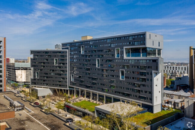
3925 Walnut St
881600508
100 E 40TH ST
Apartment
Philadelphia
X
Pennsylvania
42045C0150F
1.58 AC
2024
University City
2026
Philadelphia
008802
Philadelphia-Camden-Wilmington, PA-NJ-DE-MD
304,000 SF
DEMOGRAPHICS near 3925 Walnut St
1 Mile
3 Mile
5 Mile
2024 Total Population
66,594
523,443
962,330
2029 Population
65,522
510,971
944,075
Pop Growth 2024-2029
(1.61%)
(2.38%)
(1.90%)
Average Age
30
37
37
2024 Total Households
25,640
229,117
406,037
HH Growth 2024-2029
(2.03%)
(2.69%)
(2.17%)
Median Household Inc
$35,562
$54,551
$56,216
Avg Household Size
2.00
2.10
2.20
2024 Avg HH Vehicles
1.00
1.00
1.00
Median Home Value
$346,645
$265,705
$246,367
Median Year Built
1955
1948
1948
Nearby Places
Map Layers
Map Styles
 Street
 Aerial
- Restaurants
- Banks
- Shops
- Fitness
- Groceries
PUBLIC TRANSPORTATION
TRANSIT/SUBWAY
40Th Street (Market-Frankford Line - Southeastern Pennsylvania Transportation Authority Rapid Transit (SEPTA Subway & Trolley))
DRIVE
WALK
Distance
40Th Street (Market-Frankford Line - Southeastern Pennsylvania Transportation Authority Rapid Transit (SEPTA Subway & Trolley))
3 min
5 min
0.3 mi
40Th-Market (Route 11 - SEPTA, Route 34 - SEPTA, Route 36 - SEPTA)
DRIVE
WALK
Distance
40Th-Market (Route 11 - SEPTA, Route 34 - SEPTA, Route 36 - SEPTA)
2 min
5 min
0.3 mi
40Th St & Filbert St (Route 10 - SEPTA)
DRIVE
WALK
Distance
40Th St & Filbert St (Route 10 - SEPTA)
2 min
6 min
0.3 mi
37Th St (Route 11 - SEPTA, Route 13 - SEPTA, Route 34 - SEPTA, Route 36 - SEPTA)
DRIVE
WALK
Distance
37Th St (Route 11 - SEPTA, Route 13 - SEPTA, Route 34 - SEPTA, Route 36 - SEPTA)
1 min
8 min
0.4 mi
37Th Street (Route 11 - Southeastern Pennsylvania Transportation Authority Rapid Transit (SEPTA Subway & Trolley), Route 13 - Southeastern Pennsylvania Transportation Authority Rapid Transit (SEPTA Subway & Trolley), Route 34 - Southeastern Pennsylvania Transportation Authority Rapid Transit (SEPTA Subway & Trolley), Route 36 - Southeastern Pennsylvania Transportation Authority Rapid Transit (SEPTA Subway & Trolley))
DRIVE
WALK
Distance
37Th Street (Route 11 - Southeastern Pennsylvania Transportation Authority Rapid Transit (SEPTA Subway & Trolley), Route 13 - Southeastern Pennsylvania Transportation Authority Rapid Transit (SEPTA Subway & Trolley), Route 34 - Southeastern Pennsylvania Transportation Authority Rapid Transit (SEPTA Subway & Trolley), Route 36 - Southeastern Pennsylvania Transportation Authority Rapid Transit (SEPTA Subway & Trolley))
1 min
8 min
0.4 mi
COMMUTER RAIL
Penn Medicine Station (Airport Line - SEPTA, Lansdale/Doylestown Line - SEPTA, Media/Wawa Line - SEPTA, Wilmington/Newark Line - SEPTA)
DRIVE
WALK
Distance
Penn Medicine Station (Airport Line - SEPTA, Lansdale/Doylestown Line - SEPTA, Media/Wawa Line - SEPTA, Wilmington/Newark Line - SEPTA)
3 min
17 min
0.9 mi
30Th St Lower Level (Airport Line - SEPTA, Wilmington/Newark Line - SEPTA)
DRIVE
WALK
Distance
30Th St Lower Level (Airport Line - SEPTA, Wilmington/Newark Line - SEPTA)
4 min
19 min
1.0 mi
AIRPORT
Philadelphia International
DRIVE
WALK
Distance
Philadelphia International
19 min
9.1 mi
Freight Ports
South Jersey Port
DRIVE
WALK
Distance
South Jersey Port
15 min
7.0 mi
SALE & LEASE HISTORY
LISTING DATE
SALE/LEASE

May 28, 2021
For Lease
Feb 16, 2024
For Lease
Apr 10, 2019
For Lease
Nearby Properties
Address
Land Use
TOTAL SIZE
Lot Size
Zoning
Address
Land Use
TOTAL SIZE
Lot Size
Zoning
1,449,928 SF
1.22 AC
CMX5
Address
Land Use
TOTAL SIZE
Lot Size
Zoning
1,076,400 SF
5 AC
CMX4
Address
Land Use
TOTAL SIZE
Lot Size
Zoning
1,200,021 SF
0.69 AC
CMX5
Address
Land Use
TOTAL SIZE
Lot Size
Zoning
26,690 SF
500 AC
SPINS
Address
Land Use
TOTAL SIZE
Lot Size
Zoning
1,103,300 SF
1.18 AC
CMX5
Address
Land Use
TOTAL SIZE
Lot Size
Zoning
1,464,000 SF
0.76 AC
CMX5
Address
Land Use
TOTAL SIZE
Lot Size
Zoning
319,590 SF
0.87 AC
I2
Address
Land Use
TOTAL SIZE
Lot Size
Zoning
760,635 SF
0.77 AC
CMX5
Address
Land Use
TOTAL SIZE
Lot Size
Zoning
1,179,072 SF
8.90 AC
RM4
Address
Land Use
TOTAL SIZE
Lot Size
Zoning
1,296,804 SF
2.71 AC
I2
Address
Land Use
TOTAL SIZE
Lot Size
Zoning
782,208 SF
0.68 AC
CMX5
Address
Land Use
TOTAL SIZE
Lot Size
Zoning
2,215,276 SF
2.46 AC
CMX5
Address
Land Use
TOTAL SIZE
Lot Size
Zoning
624,696 SF
5.79 AC
CMX4
Address
Land Use
TOTAL SIZE
Lot Size
Zoning
1,200,000 SF
1.78 AC
CMX5
Address
Land Use
TOTAL SIZE
Lot Size
Zoning
1,075,580 SF
2.65 AC
CMX5
Address
Land Use
TOTAL SIZE
Lot Size
Zoning
468,307 SF
2.45 AC
CMX4
Address
Land Use
TOTAL SIZE
Lot Size
Zoning
500,165 SF
2.16 AC
SPPOA
Address
Land Use
TOTAL SIZE
Lot Size
Zoning
1,152,520 SF
1.49 AC
CMX5
Address
Land Use
TOTAL SIZE
Lot Size
Zoning
696,920 SF
10.55 AC
SPINS
Address
Land Use
TOTAL SIZE
Lot Size
Zoning
1,143,040 SF
0.81 AC
CMX5
Address
Land Use
TOTAL SIZE
Lot Size
Zoning
738,750 SF
1.19 AC
CMX5
Address
Land Use
TOTAL SIZE
Lot Size
Zoning
700,000 SF
7.88 AC
CMX5
Address
Land Use
TOTAL SIZE
Lot Size
Zoning
1,102,992 SF
2.14 AC
CMX5
Address
Land Use
TOTAL SIZE
Lot Size
Zoning
1.88 AC
SPINS
Address
Land Use
TOTAL SIZE
Lot Size
Zoning
738,207 SF
0.89 AC
CMX5
Address
Land Use
TOTAL SIZE
Lot Size
Zoning
665,742 SF
0.98 AC
CMX4
Address
Land Use
TOTAL SIZE
Lot Size
Zoning
1,152,480 SF
1.48 AC
CMX5
Address
Land Use
TOTAL SIZE
Lot Size
Zoning
1,011,079 SF
5.82 AC
CMX5
Address
Land Use
TOTAL SIZE
Lot Size
Zoning
677,140 SF
0.53 AC
CMX5
Address
Land Use
TOTAL SIZE
Lot Size
Zoning
728,244 SF
5.56 AC
CMX4
The World's #1 Commercial Real Estate Marketplace
Connect with us
© 2025 CoStar Group
The information above has been obtained from sources believed reliable. While we do not doubt its accuracy we have not verified it and make no guarantee, warranty or representation about it. It is your responsibility to independently confirm its accuracy and completeness. Any projections, opinions, assumptions, or estimates used are for example only and do not represent the current or future performance of the property. The value of this transaction to you depends on tax and other factors which should be evaluated by your tax, financial, and legal advisors. You and your advisors should conduct a careful, independent investigation of the property to determine to your satisfaction the suitability of the property for your needs.