Property Record
3926 S 9Th St, Kalamazoo, MI 49009


Save to a Folder
{{folder.Name}}
{{folder.ListingIds.length}} Properties
{{folder.ListingIds.length}} Property
Create a New Folder
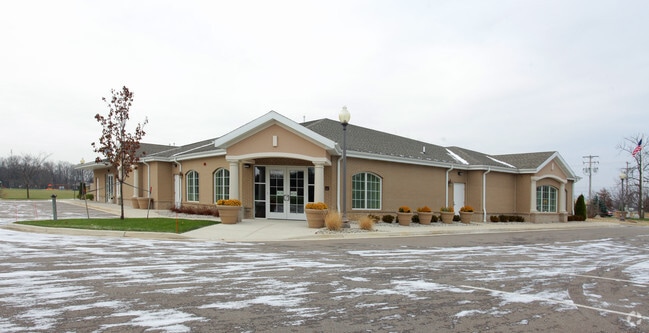
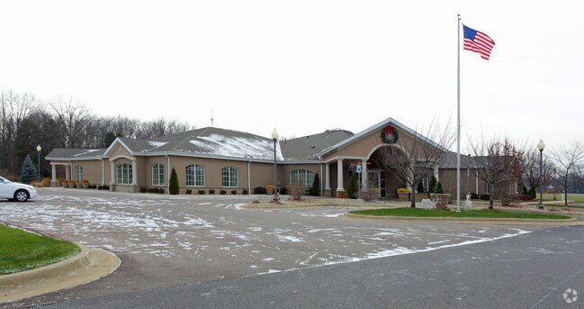
Property Detail
3926 S 9Th St
05-35-330-018
SEC 35-2-12 COMM AT W 1/4 POST TH S00DEG00'40"W ALG W SEC LI 139.08' TO SLY ROW OF AT&T CO ROW TH N60DEG30'59"E ALG SD ROW
Commercialnec
Kalamazoo
VC VILL
Michigan
B and X Area of moderate flood hazard, usually the area between the limits of the 100-year and 500-year floods.
6.85 AC
2025
Western Kalamazoo County
2026
West Michigan
002910
Kalamazoo-Portage, MI
19,819 SF
NEARBY LISTINGS FOR SALE OR LEASE
DEMOGRAPHICS near 3926 S 9Th St
1 mile
3 mile
5 mile
2025 Total Population
3,188
39,153
122,190
2030 Population
3,222
39,970
124,938
Pop Growth 2025-2030
+ 1.07%
+ 2.09%
+ 2.25%
Average Age
41
36
37
2025 Total Households
1,460
16,953
49,777
HH Growth 2025-2030
+ 0.75%
+ 2.01%
+ 2.33%
Median Household Inc
$55,312
$63,430
$67,078
Avg Household Size
2.20
2.30
2.30
2025 Avg HH Vehicles
2.00
2.00
2.00
Median Home Value
$274,456
$312,206
$288,243
Median Year Built
1993
1990
1982
Nearby Places
Map Layers
Map Styles
 Street
 Aerial
Layers
 Traffic
 Biking
Places
Listings with unknown addresses are not visible on the map
- Restaurants
- Banks
- Shops
- Fitness
- Groceries
PUBLIC TRANSPORTATION
COMMUTER RAIL
Drive
Walk
Distance
13 min
6.4 mi
AIRPORT
Kalamazoo/Battle Creek International
Drive
Walk
Distance
Kalamazoo/Battle Creek International
18 min
9.2 mi
Nearby Properties
Address
Land Use
TOTAL SIZE
Lot Size
Zoning
Address
Land Use
TOTAL SIZE
Lot Size
Zoning
449,275 SF
33.70 AC
R-4 MUL
Address
Land Use
TOTAL SIZE
Lot Size
Zoning
204,579 SF
27.80 AC
R-4 MUL
Address
Land Use
TOTAL SIZE
Lot Size
Zoning
1,703 SF
20.29 AC
R-2
Address
Land Use
TOTAL SIZE
Lot Size
Zoning
35,870 SF
12.78 AC
CC
Address
Land Use
TOTAL SIZE
Lot Size
Zoning
331,571 SF
19.68 AC
RM-15
Address
Land Use
TOTAL SIZE
Lot Size
Zoning
304,247 SF
44.91 AC
R-4 MUL
Address
Land Use
TOTAL SIZE
Lot Size
Zoning
315,422 SF
25.40 AC
RM-15
Address
Land Use
TOTAL SIZE
Lot Size
Zoning
126.09 AC
R-5 MHP
Address
Land Use
TOTAL SIZE
Lot Size
Zoning
424,967 SF
55.60 AC
I-1
Address
Land Use
TOTAL SIZE
Lot Size
Zoning
447,142 SF
34.79 AC
R-4 MUL
Address
Land Use
TOTAL SIZE
Lot Size
Zoning
291,495 SF
18.39 AC
PUD
Address
Land Use
TOTAL SIZE
Lot Size
Zoning
55.46 AC
R-5 MHP
Address
Land Use
TOTAL SIZE
Lot Size
Zoning
17.31 AC
PD
Address
Land Use
TOTAL SIZE
Lot Size
Zoning
128,586 SF
14.27 AC
R-4 MUL
Address
Land Use
TOTAL SIZE
Lot Size
Zoning
230,820 SF
16.50 AC
R-4 MUL
Address
Land Use
TOTAL SIZE
Lot Size
Zoning
140,000 SF
22.69 AC
EBT
Address
Land Use
TOTAL SIZE
Lot Size
Zoning
235,227 SF
25.18 AC
R-4 MUL
Address
Land Use
TOTAL SIZE
Lot Size
Zoning
5,173 SF
15.81 AC
RM-1
Address
Land Use
TOTAL SIZE
Lot Size
Zoning
224,424 SF
18.89 AC
R-4 MUL
Address
Land Use
TOTAL SIZE
Lot Size
Zoning
216,972 SF
30.83 AC
C COMM
Address
Land Use
TOTAL SIZE
Lot Size
Zoning
23,463 SF
15 AC
PD
Address
Land Use
TOTAL SIZE
Lot Size
Zoning
12,480 SF
14.82 AC
RM-1
Address
Land Use
TOTAL SIZE
Lot Size
Zoning
179,628 SF
12.99 AC
RM-15
Address
Land Use
TOTAL SIZE
Lot Size
Zoning
8.83 AC
I-1
Address
Land Use
TOTAL SIZE
Lot Size
Zoning
178,882 SF
10.02 AC
RS-5
Address
Land Use
TOTAL SIZE
Lot Size
Zoning
4.33 AC
C-1
Address
Land Use
TOTAL SIZE
Lot Size
Zoning
153,637 SF
12.28 AC
PUD
Address
Land Use
TOTAL SIZE
Lot Size
Zoning
161,530 SF
10.01 AC
RM-15
Address
Land Use
TOTAL SIZE
Lot Size
Zoning
115,455 SF
15.09 AC
CBTR
Address
Land Use
TOTAL SIZE
Lot Size
Zoning
124,845 SF
12.65 AC
RM-15
The World's #1 Commercial Real Estate Marketplace
Connect with us
© 2026 CoStar Group
The information above has been obtained from sources believed reliable. While we do not doubt its accuracy we have not verified it and make no guarantee, warranty or representation about it. It is your responsibility to independently confirm its accuracy and completeness. Any projections, opinions, assumptions, or estimates used are for example only and do not represent the current or future performance of the property. The value of this transaction to you depends on tax and other factors which should be evaluated by your tax, financial, and legal advisors. You and your advisors should conduct a careful, independent investigation of the property to determine to your satisfaction the suitability of the property for your needs.