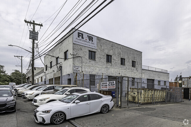
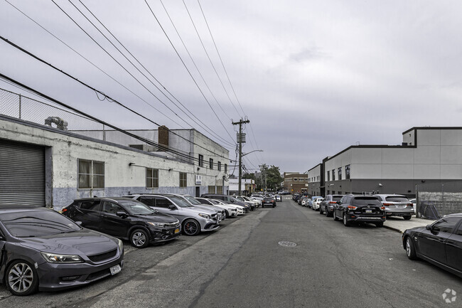
Property Record
3920 Merritt Ave, Bronx, NY 10466

NEARBY LISTINGS FOR SALE OR LEASE
Property Detail
3920 Merritt Ave
04972-0012
Bronx
Industrialgeneral
New York
X
12
36119C0339F
0.46 AC
2024
Bronx
2025
Westchester/So Connecticut
045600
New York-Jersey City-White Plains, NY-NJ
22,500 SF
DEMOGRAPHICS near 3920 Merritt Ave
1 mile
3 mile
5 mile
2024 Total Population
45,022
426,818
1,207,322
2029 Population
40,672
395,971
1,129,040
Pop Growth 2024-2029
(9.66%)
(7.23%)
(6.48%)
Average Age
42
40
39
2024 Total Households
16,726
159,323
439,510
HH Growth 2024-2029
(10.28%)
(7.51%)
(6.94%)
Median Household Inc
$61,129
$63,792
$56,189
Avg Household Size
2.60
2.50
2.60
2024 Avg HH Vehicles
1.00
1.00
1.00
Median Home Value
$396,236
$485,407
$529,826
Median Year Built
1960
1952
1950
Nearby Places
Map Layers
Map Styles
 Street
 Aerial
Transit
 Traffic
 Biking
Places
Listings with unknown addresses are not visible on the map
- Restaurants
- Banks
- Shops
- Fitness
- Groceries
PUBLIC TRANSPORTATION
TRANSIT/SUBWAY
Eastchester-Dyre Ave (5 - New York MTA Subway (The Subway))
Drive
Walk
Distance
Eastchester-Dyre Ave (5 - New York MTA Subway (The Subway))
1 min
5 min
0.3 mi
Baychester Avenue (5 - New York MTA Subway (The Subway))
Drive
Walk
Distance
Baychester Avenue (5 - New York MTA Subway (The Subway))
2 min
20 min
1.1 mi
COMMUTER RAIL
Mount Vernon East Station (New Haven Line - Metro-North Commuter Railroad Company (Metro-North))
Drive
Walk
Distance
Mount Vernon East Station (New Haven Line - Metro-North Commuter Railroad Company (Metro-North))
4 min
2.0 mi
Pelham Station (New Haven Line - Metro-North Commuter Railroad Company (Metro-North))
Drive
Walk
Distance
Pelham Station (New Haven Line - Metro-North Commuter Railroad Company (Metro-North))
5 min
2.2 mi
AIRPORT
LaGuardia
Drive
Walk
Distance
LaGuardia
23 min
12.6 mi
Westchester County
Drive
Walk
Distance
Westchester County
28 min
18.3 mi
John F Kennedy International
Drive
Walk
Distance
John F Kennedy International
29 min
20.2 mi
Freight Ports
NY - Red Hook Container Terminal
Drive
Walk
Distance
NY - Red Hook Container Terminal
37 min
23.1 mi
SALE & LEASE HISTORY
LISTING DATE
SALE/LEASE

Sep 18, 2020
For Lease
Nearby Properties
Address
Land Use
TOTAL SIZE
Lot Size
Zoning
Address
Land Use
TOTAL SIZE
Lot Size
Zoning
115.90 AC
R6
Address
Land Use
TOTAL SIZE
Lot Size
Zoning
115.90 AC
R6
Address
Land Use
TOTAL SIZE
Lot Size
Zoning
115.90 AC
R6
Address
Land Use
TOTAL SIZE
Lot Size
Zoning
115.90 AC
R6
Address
Land Use
TOTAL SIZE
Lot Size
Zoning
115.90 AC
R6
Address
Land Use
TOTAL SIZE
Lot Size
Zoning
115.90 AC
R6
Address
Land Use
TOTAL SIZE
Lot Size
Zoning
115.90 AC
R6
Address
Land Use
TOTAL SIZE
Lot Size
Zoning
115.90 AC
R6
Address
Land Use
TOTAL SIZE
Lot Size
Zoning
115.90 AC
R6
Address
Land Use
TOTAL SIZE
Lot Size
Zoning
115.90 AC
R6
Address
Land Use
TOTAL SIZE
Lot Size
Zoning
115.90 AC
R6
Address
Land Use
TOTAL SIZE
Lot Size
Zoning
115.90 AC
R6
Address
Land Use
TOTAL SIZE
Lot Size
Zoning
115.90 AC
R6
Address
Land Use
TOTAL SIZE
Lot Size
Zoning
115.90 AC
R6
Address
Land Use
TOTAL SIZE
Lot Size
Zoning
115.90 AC
R6
Address
Land Use
TOTAL SIZE
Lot Size
Zoning
115.90 AC
R6
Address
Land Use
TOTAL SIZE
Lot Size
Zoning
115.90 AC
R6
Address
Land Use
TOTAL SIZE
Lot Size
Zoning
115.90 AC
R6
Address
Land Use
TOTAL SIZE
Lot Size
Zoning
115.90 AC
R6
Address
Land Use
TOTAL SIZE
Lot Size
Zoning
115.90 AC
R6
Address
Land Use
TOTAL SIZE
Lot Size
Zoning
115.90 AC
R6
Address
Land Use
TOTAL SIZE
Lot Size
Zoning
115.90 AC
R6
Address
Land Use
TOTAL SIZE
Lot Size
Zoning
115.90 AC
R6
Address
Land Use
TOTAL SIZE
Lot Size
Zoning
115.90 AC
R6
Address
Land Use
TOTAL SIZE
Lot Size
Zoning
115.90 AC
R6
Address
Land Use
TOTAL SIZE
Lot Size
Zoning
550,000 SF
8.75 AC
M1-1
Address
Land Use
TOTAL SIZE
Lot Size
Zoning
13,243,398 SF
115.90 AC
R6
Address
Land Use
TOTAL SIZE
Lot Size
Zoning
44.83 AC
R6
Address
Land Use
TOTAL SIZE
Lot Size
Zoning
44.83 AC
R6
Address
Land Use
TOTAL SIZE
Lot Size
Zoning
1,427,393 SF
39.94 AC
R4
The World's #1 Commercial Real Estate Marketplace
Connect with us
© 2026 CoStar Group
The information above has been obtained from sources believed reliable. While we do not doubt its accuracy we have not verified it and make no guarantee, warranty or representation about it. It is your responsibility to independently confirm its accuracy and completeness. Any projections, opinions, assumptions, or estimates used are for example only and do not represent the current or future performance of the property. The value of this transaction to you depends on tax and other factors which should be evaluated by your tax, financial, and legal advisors. You and your advisors should conduct a careful, independent investigation of the property to determine to your satisfaction the suitability of the property for your needs.