Property Record
S Rowell Ave, Elwood, IL 60421

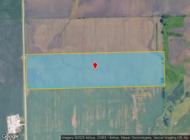
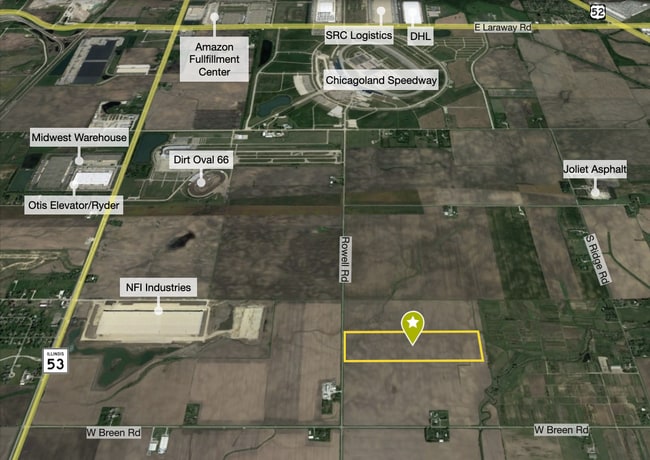
This Property Is For Sale
NEARBY LISTINGS FOR SALE OR LEASE
-
-
-
-
-
-
No Photo
-
-
View all Elwood listings for sale on LoopNet.com
Property Detail
S Rowell Ave
10-11-11-100-004
THE S 649.42 FT OF THE N 1298.79 FT, AS MEAS ALG THE W LN THROF, OF THE NW1/4 OF SEC. 11, T34N-R10E.
Agriculturalland
Will
A
Illinois
17197C0285G
39.29 AC
2024
Joliet/Central Will
2024
Chicago
883307
Chicago-Naperville-Elgin, IL-IN
DEMOGRAPHICS near S Rowell Ave
1 Mile
3 Mile
5 Mile
2024 Total Population
24
4,039
37,193
2029 Population
24
4,135
37,392
Pop Growth 2024-2029
0.00%
+ 2.38%
+ 0.54%
Average Age
48
42
38
2024 Total Households
9
1,510
12,875
HH Growth 2024-2029
+ 11.11%
+ 2.25%
+ 0.48%
Median Household Inc
$124,999
$102,778
$77,136
Avg Household Size
2.50
2.70
2.80
2024 Avg HH Vehicles
2.00
2.00
2.00
Median Home Value
$250,000
$246,422
$239,377
Median Year Built
1977
1976
1978
Nearby Places
Map Layers
Map Styles
 Street
 Aerial
- Restaurants
- Banks
- Shops
- Fitness
- Groceries
PUBLIC TRANSPORTATION
COMMUTER RAIL
Manhattan Station (SouthWest Service - Northeast Illinois Regional Commuter Railroad (Metra))
DRIVE
WALK
Distance
Manhattan Station (SouthWest Service - Northeast Illinois Regional Commuter Railroad (Metra))
12 min
5.6 mi
Joliet Station (Heritage Corridor Line - Northeast Illinois Regional Commuter Railroad (Metra), Rock Island District Line - Northeast Illinois Regional Commuter Railroad (Metra))
DRIVE
WALK
Distance
Joliet Station (Heritage Corridor Line - Northeast Illinois Regional Commuter Railroad (Metra), Rock Island District Line - Northeast Illinois Regional Commuter Railroad (Metra))
15 min
6.9 mi
AIRPORT
Chicago Midway International
DRIVE
WALK
Distance
Chicago Midway International
60 min
42.7 mi
Freight Ports
Port Milwaukee
DRIVE
WALK
Distance
Port Milwaukee
158 min
125.9 mi
Nearby Properties
Address
Land Use
TOTAL SIZE
Lot Size
Zoning
Address
Land Use
TOTAL SIZE
Lot Size
Zoning
88.74 AC
Address
Land Use
TOTAL SIZE
Lot Size
Zoning
67.82 AC
Address
Land Use
TOTAL SIZE
Lot Size
Zoning
81.93 AC
Address
Land Use
TOTAL SIZE
Lot Size
Zoning
59.92 AC
Address
Land Use
TOTAL SIZE
Lot Size
Zoning
40.74 AC
Address
Land Use
TOTAL SIZE
Lot Size
Zoning
64.27 AC
Address
Land Use
TOTAL SIZE
Lot Size
Zoning
61,681 SF
70.64 AC
Address
Land Use
TOTAL SIZE
Lot Size
Zoning
41.70 AC
Address
Land Use
TOTAL SIZE
Lot Size
Zoning
51.81 AC
Address
Land Use
TOTAL SIZE
Lot Size
Zoning
49.35 AC
Address
Land Use
TOTAL SIZE
Lot Size
Zoning
52.66 AC
Address
Land Use
TOTAL SIZE
Lot Size
Zoning
24.66 AC
Address
Land Use
TOTAL SIZE
Lot Size
Zoning
22.24 AC
Address
Land Use
TOTAL SIZE
Lot Size
Zoning
34.48 AC
Address
Land Use
TOTAL SIZE
Lot Size
Zoning
Address
Land Use
TOTAL SIZE
Lot Size
Zoning
36.54 AC
Address
Land Use
TOTAL SIZE
Lot Size
Zoning
16.02 AC
Address
Land Use
TOTAL SIZE
Lot Size
Zoning
18.88 AC
Address
Land Use
TOTAL SIZE
Lot Size
Zoning
38.40 AC
Address
Land Use
TOTAL SIZE
Lot Size
Zoning
5.12 AC
Address
Land Use
TOTAL SIZE
Lot Size
Zoning
26.83 AC
Address
Land Use
TOTAL SIZE
Lot Size
Zoning
10.73 AC
Address
Land Use
TOTAL SIZE
Lot Size
Zoning
20.74 AC
Address
Land Use
TOTAL SIZE
Lot Size
Zoning
47.34 AC
Address
Land Use
TOTAL SIZE
Lot Size
Zoning
11.04 AC
Address
Land Use
TOTAL SIZE
Lot Size
Zoning
12.08 AC
Address
Land Use
TOTAL SIZE
Lot Size
Zoning
46.83 AC
Address
Land Use
TOTAL SIZE
Lot Size
Zoning
78.91 AC
Address
Land Use
TOTAL SIZE
Lot Size
Zoning
16.77 AC
Address
Land Use
TOTAL SIZE
Lot Size
Zoning
65.70 AC
The World's #1 Commercial Real Estate Marketplace
Connect with us
© 2026 CoStar Group
The information above has been obtained from sources believed reliable. While we do not doubt its accuracy we have not verified it and make no guarantee, warranty or representation about it. It is your responsibility to independently confirm its accuracy and completeness. Any projections, opinions, assumptions, or estimates used are for example only and do not represent the current or future performance of the property. The value of this transaction to you depends on tax and other factors which should be evaluated by your tax, financial, and legal advisors. You and your advisors should conduct a careful, independent investigation of the property to determine to your satisfaction the suitability of the property for your needs.