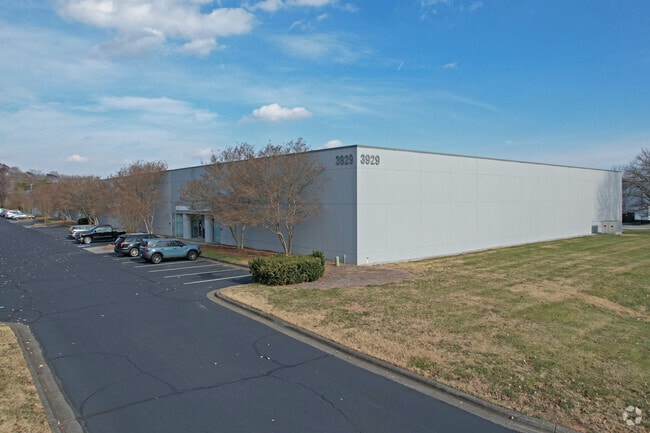
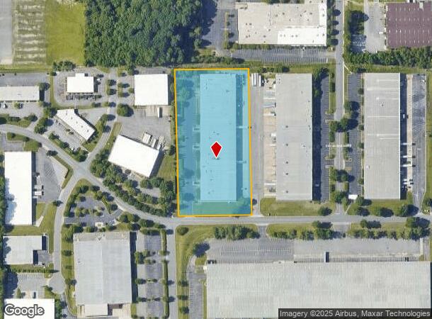
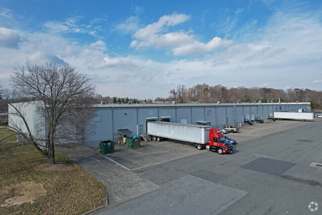
Property Record
3929 Westpoint Blvd, Winston Salem, NC 27103
NEARBY LISTINGS FOR SALE OR LEASE
Property Detail
3929 Westpoint Blvd
Winston-Salem, NC
Direct Marketing/Resource
6803-85-5945
R&D AND FLEX WHSE LO:011 BL:6183 BU:1
Commercialnec
Forsyth
X
North Carolina
3710680300J
11
2024
4.93 AC
2025
South Forsyth County
003804
Greensboro/Winston-Salem
765 SF
DEMOGRAPHICS near 3929 Westpoint Blvd
1 Mile
3 Mile
5 Mile
2024 Total Population
2,783
41,612
123,370
2029 Population
2,880
43,151
128,265
Pop Growth 2024-2029
+ 3.49%
+ 3.70%
+ 3.97%
Average Age
39
40
41
2024 Total Households
1,261
18,482
53,537
HH Growth 2024-2029
+ 3.57%
+ 3.72%
+ 3.99%
Median Household Inc
$53,678
$57,552
$65,516
Avg Household Size
2.20
2.20
2.20
2024 Avg HH Vehicles
2.00
2.00
2.00
Median Home Value
$215,384
$185,609
$224,237
Median Year Built
2002
1988
1984
Nearby Places
Map Layers
Map Styles
 Street
 Aerial
- Restaurants
- Banks
- Shops
- Fitness
- Groceries
PUBLIC TRANSPORTATION
AIRPORT
Piedmont Triad International
DRIVE
WALK
Distance
Piedmont Triad International
42 min
27.6 mi
Freight Ports
Port of Wilmington
DRIVE
WALK
Distance
Port of Wilmington
280 min
236.3 mi
SALE & LEASE HISTORY
LISTING DATE
SALE/LEASE

Nov 20, 2018
For Lease
Apr 28, 2021
For Lease
Nearby Properties
Address
Land Use
TOTAL SIZE
Lot Size
Zoning
Address
Land Use
TOTAL SIZE
Lot Size
Zoning
133,360 SF
60.44 AC
C,RMU-S
Address
Land Use
TOTAL SIZE
Lot Size
Zoning
822,684 SF
33.33 AC
GB
Address
Land Use
TOTAL SIZE
Lot Size
Zoning
125,328 SF
19.14 AC
RM18-S
Address
Land Use
TOTAL SIZE
Lot Size
Zoning
120,259 SF
13.68 AC
MU-S
Address
Land Use
TOTAL SIZE
Lot Size
Zoning
30,360 SF
17.09 AC
CPO-S
Address
Land Use
TOTAL SIZE
Lot Size
Zoning
297,487 SF
40.24 AC
RM12,RM18
Address
Land Use
TOTAL SIZE
Lot Size
Zoning
143,081 SF
4.88 AC
GB-S
Address
Land Use
TOTAL SIZE
Lot Size
Zoning
198,730 SF
37.41 AC
RS9
Address
Land Use
TOTAL SIZE
Lot Size
Zoning
153,436 SF
17.46 AC
GB-S
Address
Land Use
TOTAL SIZE
Lot Size
Zoning
68,656 SF
6.25 AC
MU-S
Address
Land Use
TOTAL SIZE
Lot Size
Zoning
257,080 SF
23.47 AC
HB-S
Address
Land Use
TOTAL SIZE
Lot Size
Zoning
160,690 SF
17.81 AC
GB-S
Address
Land Use
TOTAL SIZE
Lot Size
Zoning
183,444 SF
45.19 AC
RS9
Address
Land Use
TOTAL SIZE
Lot Size
Zoning
129,977 SF
7.51 AC
RM12-S
Address
Land Use
TOTAL SIZE
Lot Size
Zoning
88,466 SF
9.94 AC
GO-S
Address
Land Use
TOTAL SIZE
Lot Size
Zoning
81,061 SF
10.33 AC
GB
Address
Land Use
TOTAL SIZE
Lot Size
Zoning
390,230 SF
35.43 AC
GI,RS9
Address
Land Use
TOTAL SIZE
Lot Size
Zoning
111,173 SF
11.19 AC
GB-S,LB-S
Address
Land Use
TOTAL SIZE
Lot Size
Zoning
51,122 SF
10.64 AC
RM18-S
Address
Land Use
TOTAL SIZE
Lot Size
Zoning
98,061 SF
15.87 AC
RM12-S,RM1
Address
Land Use
TOTAL SIZE
Lot Size
Zoning
127,588 SF
14.47 AC
GB
Address
Land Use
TOTAL SIZE
Lot Size
Zoning
148,131 SF
17.80 AC
GB-S
Address
Land Use
TOTAL SIZE
Lot Size
Zoning
78,437 SF
9.94 AC
CPO,CPO-S,
Address
Land Use
TOTAL SIZE
Lot Size
Zoning
64,236 SF
14.71 AC
RM12-S
Address
Land Use
TOTAL SIZE
Lot Size
Zoning
136,400 SF
16.54 AC
GB-S
Address
Land Use
TOTAL SIZE
Lot Size
Zoning
116,670 SF
95.97 AC
IP-S
Address
Land Use
TOTAL SIZE
Lot Size
Zoning
100,247 SF
9.68 AC
GB
Address
Land Use
TOTAL SIZE
Lot Size
Zoning
85,968 SF
9.54 AC
GO,GO-S
Address
Land Use
TOTAL SIZE
Lot Size
Zoning
62,546 SF
4.63 AC
LO-S
Address
Land Use
TOTAL SIZE
Lot Size
Zoning
35,723 SF
5.45 AC
RMU-S
The World's #1 Commercial Real Estate Marketplace
Connect with us
© 2025 CoStar Group
The information above has been obtained from sources believed reliable. While we do not doubt its accuracy we have not verified it and make no guarantee, warranty or representation about it. It is your responsibility to independently confirm its accuracy and completeness. Any projections, opinions, assumptions, or estimates used are for example only and do not represent the current or future performance of the property. The value of this transaction to you depends on tax and other factors which should be evaluated by your tax, financial, and legal advisors. You and your advisors should conduct a careful, independent investigation of the property to determine to your satisfaction the suitability of the property for your needs.