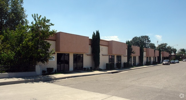
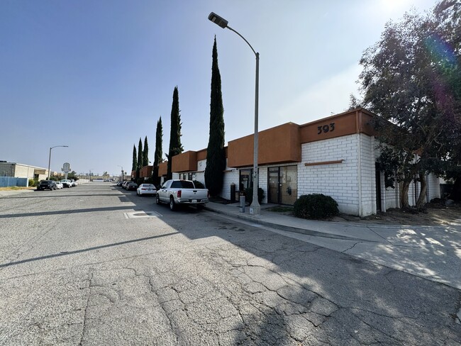
Property Record
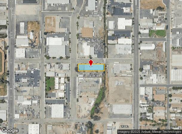
393 Athol St, San Bernardino, CA 92401

Current Lease Availabilities
NEARBY LISTINGS FOR SALE OR LEASE
Property Detail
393 Athol St
Riverside-San Bernardino-Ontario, CA
The Peppers
0136-132-28
THE PEPPERS PTN LOT 27 BLK C LYING W OF W LI PROP CONVEYED TO CITY OF SAN BERNARDINO BY DEED RECORDED 4/29/68 IN BOOK 7016 PAGE 885 OFFICIAL RECORDS EX ANY PTN IN D ST
Loftbuilding
San Bernardino
X
California
06071C8681J
27
2024
0.47 AC
2025
San Bernardino
005701
Inland Empire (California)
18,240 SF
DEMOGRAPHICS near 393 Athol St
1 Mile
3 Mile
5 Mile
2024 Total Population
7,695
127,212
364,068
2029 Population
7,829
128,748
370,287
Pop Growth 2024-2029
+ 1.74%
+ 1.21%
+ 1.71%
Average Age
37
34
35
2024 Total Households
2,644
34,961
105,289
HH Growth 2024-2029
+ 2.38%
+ 1.31%
+ 1.83%
Median Household Inc
$24,209
$50,218
$58,711
Avg Household Size
2.70
3.50
3.30
2024 Avg HH Vehicles
1.00
2.00
2.00
Median Home Value
$256,481
$298,473
$343,133
Median Year Built
1974
1962
1970
Nearby Places
Map Layers
Map Styles
 Street
 Aerial
- Restaurants
- Banks
- Shops
- Fitness
- Groceries
PUBLIC TRANSPORTATION
COMMUTER RAIL
DRIVE
WALK
Distance
3 min
11 min
0.6 mi
San Bernardino (Inland Empire-Orange County Line - Southern California Regional Rail Authority (Metrolink), San Bernardino Line - Southern California Regional Rail Authority (Metrolink))
DRIVE
WALK
Distance
San Bernardino (Inland Empire-Orange County Line - Southern California Regional Rail Authority (Metrolink), San Bernardino Line - Southern California Regional Rail Authority (Metrolink))
4 min
1.5 mi
AIRPORT
Ontario International
DRIVE
WALK
Distance
Ontario International
28 min
20.2 mi
Nearby Properties
Address
Land Use
TOTAL SIZE
Lot Size
Zoning
Address
Land Use
TOTAL SIZE
Lot Size
Zoning
2,134,798 SF
153.92 AC
Address
Land Use
TOTAL SIZE
Lot Size
Zoning
778,653 SF
19.31 AC
Address
Land Use
TOTAL SIZE
Lot Size
Zoning
457,253 SF
20.14 AC
Address
Land Use
TOTAL SIZE
Lot Size
Zoning
497,664 SF
56.39 AC
Address
Land Use
TOTAL SIZE
Lot Size
Zoning
1,032,072 SF
61.74 AC
Address
Land Use
TOTAL SIZE
Lot Size
Zoning
330,420 SF
15.31 AC
Address
Land Use
TOTAL SIZE
Lot Size
Zoning
1,081,199 SF
49.77 AC
Address
Land Use
TOTAL SIZE
Lot Size
Zoning
300,188 SF
11.98 AC
Address
Land Use
TOTAL SIZE
Lot Size
Zoning
379,299 SF
19.97 AC
Address
Land Use
TOTAL SIZE
Lot Size
Zoning
1,139,976 SF
49.56 AC
Address
Land Use
TOTAL SIZE
Lot Size
Zoning
758,180 SF
31.86 AC
Address
Land Use
TOTAL SIZE
Lot Size
Zoning
391,468 SF
16.73 AC
Address
Land Use
TOTAL SIZE
Lot Size
Zoning
1,205,400 SF
58.05 AC
Address
Land Use
TOTAL SIZE
Lot Size
Zoning
210,418 SF
12.09 AC
Address
Land Use
TOTAL SIZE
Lot Size
Zoning
951,686 SF
47.90 AC
Address
Land Use
TOTAL SIZE
Lot Size
Zoning
913,716 SF
20 AC
Address
Land Use
TOTAL SIZE
Lot Size
Zoning
474,680 SF
17.95 AC
Address
Land Use
TOTAL SIZE
Lot Size
Zoning
851,880 SF
42.20 AC
Address
Land Use
TOTAL SIZE
Lot Size
Zoning
404,725 SF
19.29 AC
Address
Land Use
TOTAL SIZE
Lot Size
Zoning
472,962 SF
23.28 AC
Address
Land Use
TOTAL SIZE
Lot Size
Zoning
178,926 SF
9.12 AC
IC
Address
Land Use
TOTAL SIZE
Lot Size
Zoning
549,796 SF
13.61 AC
Address
Land Use
TOTAL SIZE
Lot Size
Zoning
344,757 SF
14.89 AC
Address
Land Use
TOTAL SIZE
Lot Size
Zoning
335,000 SF
8.44 AC
Address
Land Use
TOTAL SIZE
Lot Size
Zoning
151,859 SF
7.23 AC
Address
Land Use
TOTAL SIZE
Lot Size
Zoning
415,405 SF
18.43 AC
IC
Address
Land Use
TOTAL SIZE
Lot Size
Zoning
592,710 SF
28.89 AC
Address
Land Use
TOTAL SIZE
Lot Size
Zoning
318,940 SF
14.26 AC
Address
Land Use
TOTAL SIZE
Lot Size
Zoning
154,639 SF
6.87 AC
Address
Land Use
TOTAL SIZE
Lot Size
Zoning
599,690 SF
17.08 AC
IC
The World's #1 Commercial Real Estate Marketplace
Connect with us
© 2026 CoStar Group
The information above has been obtained from sources believed reliable. While we do not doubt its accuracy we have not verified it and make no guarantee, warranty or representation about it. It is your responsibility to independently confirm its accuracy and completeness. Any projections, opinions, assumptions, or estimates used are for example only and do not represent the current or future performance of the property. The value of this transaction to you depends on tax and other factors which should be evaluated by your tax, financial, and legal advisors. You and your advisors should conduct a careful, independent investigation of the property to determine to your satisfaction the suitability of the property for your needs.