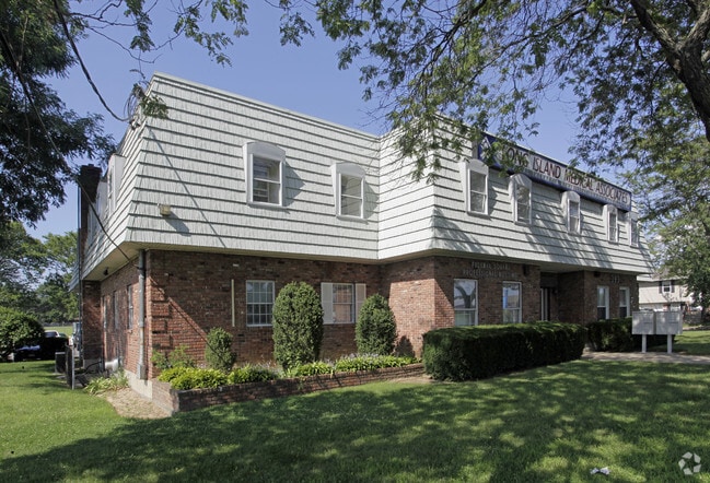
Property Record
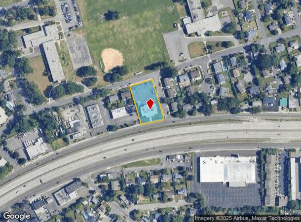
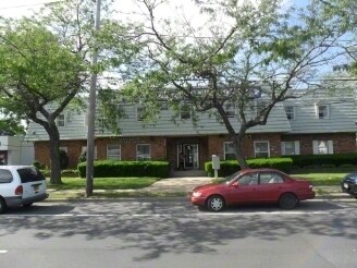
393 Sunrise Hwy, West Babylon, NY 11704

Current Lease Availabilities
NEARBY LISTINGS FOR SALE OR LEASE
Property Detail
393 Sunrise Hwy
0100-134-00-02-00-041-000
F M 276 LT 53 PT
Financialbuilding
Suffolk
X
New York
36103C0853H
41
2024
0.78 AC
2024
Southwestern Suffolk
123500
Long Island (New York)
12,464 SF
Nassau County-Suffolk County, NY
DEMOGRAPHICS near 393 Sunrise Hwy
1 Mile
3 Mile
5 Mile
2024 Total Population
20,514
137,280
291,291
2029 Population
19,885
134,064
285,014
Pop Growth 2024-2029
(3.07%)
(2.34%)
(2.15%)
Average Age
41
40
41
2024 Total Households
6,981
43,907
95,723
HH Growth 2024-2029
(3.25%)
(2.57%)
(2.36%)
Median Household Inc
$113,088
$111,764
$113,835
Avg Household Size
2.90
3.00
2.90
2024 Avg HH Vehicles
2.00
2.00
2.00
Median Home Value
$438,435
$447,740
$467,370
Median Year Built
1960
1960
1961
Nearby Places
- Restaurants
- Banks
- Shops
- Fitness
- Groceries
PUBLIC TRANSPORTATION
COMMUTER RAIL
Lindenhurst Station (Babylon Branch - Long Island Rail Road)
DRIVE
WALK
Distance
Lindenhurst Station (Babylon Branch - Long Island Rail Road)
5 min
2.9 mi
Babylon Station (Babylon Branch - Long Island Rail Road, Montauk Branch - Long Island Rail Road)
DRIVE
WALK
Distance
Babylon Station (Babylon Branch - Long Island Rail Road, Montauk Branch - Long Island Rail Road)
6 min
3.4 mi
AIRPORT
Long Island MacArthur
DRIVE
WALK
Distance
Long Island MacArthur
27 min
18.3 mi
John F Kennedy International
DRIVE
WALK
Distance
John F Kennedy International
36 min
26.1 mi
LaGuardia
DRIVE
WALK
Distance
LaGuardia
47 min
33.0 mi
Freight Ports
NY - Red Hook Container Terminal
DRIVE
WALK
Distance
NY - Red Hook Container Terminal
57 min
37.5 mi
Nearby Properties
Address
Land Use
TOTAL SIZE
Lot Size
Zoning
Address
Land Use
TOTAL SIZE
Lot Size
Zoning
4,290 SF
1.50 AC
VILLA
Address
Land Use
TOTAL SIZE
Lot Size
Zoning
24.90 AC
B
Address
Land Use
TOTAL SIZE
Lot Size
Zoning
9.70 AC
B
Address
Land Use
TOTAL SIZE
Lot Size
Zoning
19.40 AC
IND1
Address
Land Use
TOTAL SIZE
Lot Size
Zoning
6.37 AC
BUS3
Address
Land Use
TOTAL SIZE
Lot Size
Zoning
1.82 AC
Address
Land Use
TOTAL SIZE
Lot Size
Zoning
2.40 AC
A
Address
Land Use
TOTAL SIZE
Lot Size
Zoning
5,010 SF
0.30 AC
R10
Address
Land Use
TOTAL SIZE
Lot Size
Zoning
400 AC
A
Address
Land Use
TOTAL SIZE
Lot Size
Zoning
2.69 AC
BUS1
Address
Land Use
TOTAL SIZE
Lot Size
Zoning
13.63 AC
B
Address
Land Use
TOTAL SIZE
Lot Size
Zoning
0.65 AC
R40
Address
Land Use
TOTAL SIZE
Lot Size
Zoning
Address
Land Use
TOTAL SIZE
Lot Size
Zoning
44 AC
E
Address
Land Use
TOTAL SIZE
Lot Size
Zoning
2.24 AC
Address
Land Use
TOTAL SIZE
Lot Size
Zoning
2.10 AC
IND1
Address
Land Use
TOTAL SIZE
Lot Size
Zoning
16.90 AC
EA
Address
Land Use
TOTAL SIZE
Lot Size
Zoning
9.68 AC
SC
Address
Land Use
TOTAL SIZE
Lot Size
Zoning
3.80 AC
BUS1
Address
Land Use
TOTAL SIZE
Lot Size
Zoning
114.70 AC
A
Address
Land Use
TOTAL SIZE
Lot Size
Zoning
2.09 AC
BUS3
Address
Land Use
TOTAL SIZE
Lot Size
Zoning
1.50 AC
B
Address
Land Use
TOTAL SIZE
Lot Size
Zoning
16.81 AC
Address
Land Use
TOTAL SIZE
Lot Size
Zoning
248.60 AC
A
Address
Land Use
TOTAL SIZE
Lot Size
Zoning
163.50 AC
A
Address
Land Use
TOTAL SIZE
Lot Size
Zoning
12.50 AC
C
Address
Land Use
TOTAL SIZE
Lot Size
Zoning
18.30 AC
Address
Land Use
TOTAL SIZE
Lot Size
Zoning
Address
Land Use
TOTAL SIZE
Lot Size
Zoning
1,450 SF
0.08 AC
Address
Land Use
TOTAL SIZE
Lot Size
Zoning
0.63 AC
R20
The World's #1 Commercial Real Estate Marketplace
Connect with us
© 2025 CoStar Group
The information above has been obtained from sources believed reliable. While we do not doubt its accuracy we have not verified it and make no guarantee, warranty or representation about it. It is your responsibility to independently confirm its accuracy and completeness. Any projections, opinions, assumptions, or estimates used are for example only and do not represent the current or future performance of the property. The value of this transaction to you depends on tax and other factors which should be evaluated by your tax, financial, and legal advisors. You and your advisors should conduct a careful, independent investigation of the property to determine to your satisfaction the suitability of the property for your needs.