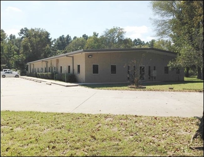
Property Record
3930 Fm 1960 Rd E, Humble, TX 77338

Save to a Folder
{{folder.Name}}
{{folder.ListingIds.length}} Properties
{{folder.ListingIds.length}} Property
Create a New Folder
Property Detail
3930 Fm 1960 Rd E
0450070003007
TR 4A-2 ABST 703 J B STEVENSON
Officebuilding
HARRIS
B and X Area of moderate flood hazard, usually the area between the limits of the 100-year and 500-year floods.
Texas
2025
1.93 AC
2025
Kingwood/Humble
250602
Houston
7,257 SF
Houston-Pasadena-The Woodlands, TX
NEARBY LISTINGS FOR SALE OR LEASE
DEMOGRAPHICS near 3930 Fm 1960 Rd E
1 mile
3 mile
5 mile
2025 Total Population
1,021
70,144
201,169
2030 Population
1,087
74,530
216,570
Pop Growth 2025-2030
+ 6.46%
+ 6.25%
+ 7.66%
Average Age
36
36
37
2025 Total Households
378
22,852
69,500
HH Growth 2025-2030
+ 6.88%
+ 6.44%
+ 8.01%
Median Household Inc
$83,295
$101,780
$97,078
Avg Household Size
2.70
3.00
2.90
2025 Avg HH Vehicles
2.00
2.00
2.00
Median Home Value
$284,042
$283,983
$309,451
Median Year Built
1997
2001
2002
Nearby Places
Map Layers
Map Styles
 Street
 Aerial
Layers
 Traffic
 Biking
Places
Listings with unknown addresses are not visible on the map
- Restaurants
- Banks
- Shops
- Fitness
- Groceries
PUBLIC TRANSPORTATION
AIRPORT
George Bush Intcntl/Houston
Drive
Walk
Distance
George Bush Intcntl/Houston
18 min
11.8 mi
William P Hobby
Drive
Walk
Distance
William P Hobby
51 min
33.5 mi
Freight Ports
Port of Houston
Drive
Walk
Distance
Port of Houston
39 min
22.8 mi
Nearby Properties
Address
Land Use
TOTAL SIZE
Lot Size
Zoning
Address
Land Use
TOTAL SIZE
Lot Size
Zoning
431,427 SF
14.62 AC
Address
Land Use
TOTAL SIZE
Lot Size
Zoning
403,142 SF
17.32 AC
Address
Land Use
TOTAL SIZE
Lot Size
Zoning
356,311 SF
15.60 AC
Address
Land Use
TOTAL SIZE
Lot Size
Zoning
306,765 SF
20.19 AC
Address
Land Use
TOTAL SIZE
Lot Size
Zoning
326,166 SF
11.84 AC
Address
Land Use
TOTAL SIZE
Lot Size
Zoning
212,020 SF
Address
Land Use
TOTAL SIZE
Lot Size
Zoning
268,939 SF
11.24 AC
Address
Land Use
TOTAL SIZE
Lot Size
Zoning
123,149 SF
14.33 AC
Address
Land Use
TOTAL SIZE
Lot Size
Zoning
135,332 SF
12.32 AC
Address
Land Use
TOTAL SIZE
Lot Size
Zoning
80,722 SF
28.27 AC
Address
Land Use
TOTAL SIZE
Lot Size
Zoning
274,992 SF
11.55 AC
Address
Land Use
TOTAL SIZE
Lot Size
Zoning
159,519 SF
16.73 AC
Address
Land Use
TOTAL SIZE
Lot Size
Zoning
174,820 SF
13.30 AC
Address
Land Use
TOTAL SIZE
Lot Size
Zoning
208,856 SF
23.08 AC
Address
Land Use
TOTAL SIZE
Lot Size
Zoning
128,886 SF
6.36 AC
Address
Land Use
TOTAL SIZE
Lot Size
Zoning
160,575 SF
3.62 AC
Address
Land Use
TOTAL SIZE
Lot Size
Zoning
176,838 SF
13.67 AC
Address
Land Use
TOTAL SIZE
Lot Size
Zoning
63,600 SF
5.99 AC
Address
Land Use
TOTAL SIZE
Lot Size
Zoning
117,795 SF
5.45 AC
Address
Land Use
TOTAL SIZE
Lot Size
Zoning
47,988 SF
1.86 AC
Address
Land Use
TOTAL SIZE
Lot Size
Zoning
77,952 SF
6.50 AC
Address
Land Use
TOTAL SIZE
Lot Size
Zoning
197,292 SF
13.77 AC
Address
Land Use
TOTAL SIZE
Lot Size
Zoning
143,220 SF
6.50 AC
Address
Land Use
TOTAL SIZE
Lot Size
Zoning
141,550 SF
5.86 AC
Address
Land Use
TOTAL SIZE
Lot Size
Zoning
137,616 SF
13.83 AC
Address
Land Use
TOTAL SIZE
Lot Size
Zoning
43,304 SF
3.85 AC
Address
Land Use
TOTAL SIZE
Lot Size
Zoning
139,808 SF
13.50 AC
Address
Land Use
TOTAL SIZE
Lot Size
Zoning
47,960 SF
25 AC
Address
Land Use
TOTAL SIZE
Lot Size
Zoning
33,674 SF
3.19 AC
Address
Land Use
TOTAL SIZE
Lot Size
Zoning
94,511 SF
4.09 AC
The World's #1 Commercial Real Estate Marketplace
Connect with us
© 2026 CoStar Group
The information above has been obtained from sources believed reliable. While we do not doubt its accuracy we have not verified it and make no guarantee, warranty or representation about it. It is your responsibility to independently confirm its accuracy and completeness. Any projections, opinions, assumptions, or estimates used are for example only and do not represent the current or future performance of the property. The value of this transaction to you depends on tax and other factors which should be evaluated by your tax, financial, and legal advisors. You and your advisors should conduct a careful, independent investigation of the property to determine to your satisfaction the suitability of the property for your needs.