Property Record
3930 Tupelo Branch Row, Awendaw, SC 29429
NEARBY LISTINGS FOR SALE OR LEASE
Property Detail
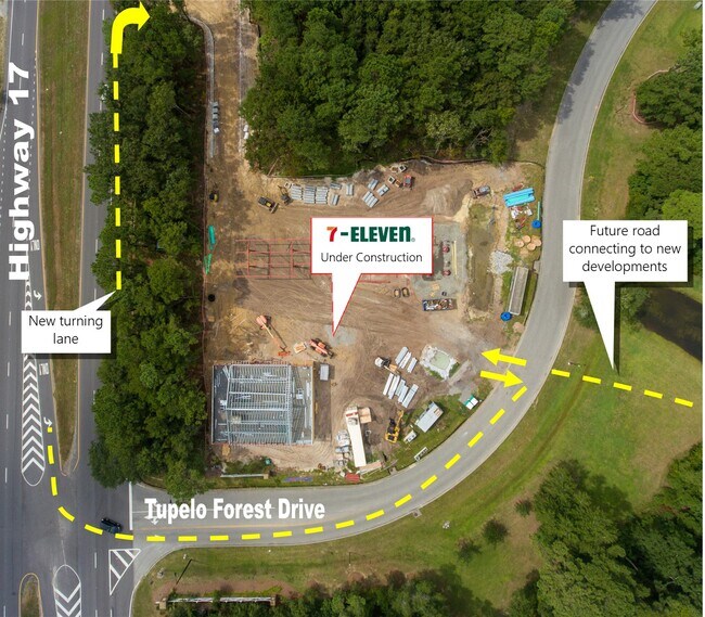
3930 Tupelo Branch Row
615-00-00-370
Town Of Mount Pleasant
Commercialnec
MAPPLATB L20 MAPPLATP 0427 SUBDIVISIONNAME TUPELO FOREST TRACT D4
X
Charleston
45019C0345K
South Carolina
2025
1.41 AC
2024
East Islands/Mt Pleasant
005002
Charleston/N Charleston
1,544 SF
Charleston-North Charleston, SC
DEMOGRAPHICS near 3930 Tupelo Branch Row
1 mile
3 mile
5 mile
2024 Total Population
3,134
19,233
38,774
2029 Population
3,392
20,625
41,457
Pop Growth 2024-2029
+ 8.23%
+ 7.24%
+ 6.92%
Average Age
41
41
42
2024 Total Households
1,125
7,032
14,181
HH Growth 2024-2029
+ 8.09%
+ 7.01%
+ 6.76%
Median Household Inc
$101,653
$112,566
$106,774
Avg Household Size
2.80
2.70
2.70
2024 Avg HH Vehicles
2.00
2.00
2.00
Median Home Value
$511,928
$529,321
$507,267
Median Year Built
2005
2007
2005
Nearby Places
Map Layers
Map Styles
 Street
 Aerial
Transit
 Traffic
 Biking
Places
Listings with unknown addresses are not visible on the map
- Restaurants
- Banks
- Shops
- Fitness
- Groceries
PUBLIC TRANSPORTATION
AIRPORT
Charleston AFB/International
Drive
Walk
Distance
Charleston AFB/International
37 min
24.5 mi
SALE & LEASE HISTORY
LISTING DATE
SALE/LEASE

Sep 29, 2021
For Sale
Nearby Properties
Address
Land Use
TOTAL SIZE
Lot Size
Zoning
Address
Land Use
TOTAL SIZE
Lot Size
Zoning
19.70 AC
Address
Land Use
TOTAL SIZE
Lot Size
Zoning
20.24 AC
Address
Land Use
TOTAL SIZE
Lot Size
Zoning
Address
Land Use
TOTAL SIZE
Lot Size
Zoning
9.11 AC
Address
Land Use
TOTAL SIZE
Lot Size
Zoning
6,622 SF
20.06 AC
Address
Land Use
TOTAL SIZE
Lot Size
Zoning
2,646 SF
16.35 AC
Address
Land Use
TOTAL SIZE
Lot Size
Zoning
Address
Land Use
TOTAL SIZE
Lot Size
Zoning
Address
Land Use
TOTAL SIZE
Lot Size
Zoning
5,209 SF
5.88 AC
Address
Land Use
TOTAL SIZE
Lot Size
Zoning
1,104 SF
13.70 AC
Address
Land Use
TOTAL SIZE
Lot Size
Zoning
4,032 SF
0.68 AC
Address
Land Use
TOTAL SIZE
Lot Size
Zoning
3,880 SF
0.27 AC
Address
Land Use
TOTAL SIZE
Lot Size
Zoning
12.60 AC
Address
Land Use
TOTAL SIZE
Lot Size
Zoning
3,134 SF
0.16 AC
Address
Land Use
TOTAL SIZE
Lot Size
Zoning
30,495 SF
8.73 AC
Address
Land Use
TOTAL SIZE
Lot Size
Zoning
45,969 SF
10.76 AC
Address
Land Use
TOTAL SIZE
Lot Size
Zoning
2,688 SF
0.26 AC
Address
Land Use
TOTAL SIZE
Lot Size
Zoning
Address
Land Use
TOTAL SIZE
Lot Size
Zoning
4,344 SF
0.41 AC
Address
Land Use
TOTAL SIZE
Lot Size
Zoning
3,366 SF
0.37 AC
Address
Land Use
TOTAL SIZE
Lot Size
Zoning
2,530 SF
0.15 AC
Address
Land Use
TOTAL SIZE
Lot Size
Zoning
3,894 SF
0.33 AC
Address
Land Use
TOTAL SIZE
Lot Size
Zoning
2,955 SF
0.18 AC
Address
Land Use
TOTAL SIZE
Lot Size
Zoning
Address
Land Use
TOTAL SIZE
Lot Size
Zoning
9.81 AC
Address
Land Use
TOTAL SIZE
Lot Size
Zoning
3,916 SF
0.36 AC
Address
Land Use
TOTAL SIZE
Lot Size
Zoning
4,293 SF
0.51 AC
Address
Land Use
TOTAL SIZE
Lot Size
Zoning
2,646 SF
0.16 AC
Address
Land Use
TOTAL SIZE
Lot Size
Zoning
3,494 SF
0.51 AC
Address
Land Use
TOTAL SIZE
Lot Size
Zoning
2,628 SF
0.34 AC
The World's #1 Commercial Real Estate Marketplace
Connect with us
© 2026 CoStar Group
The information above has been obtained from sources believed reliable. While we do not doubt its accuracy we have not verified it and make no guarantee, warranty or representation about it. It is your responsibility to independently confirm its accuracy and completeness. Any projections, opinions, assumptions, or estimates used are for example only and do not represent the current or future performance of the property. The value of this transaction to you depends on tax and other factors which should be evaluated by your tax, financial, and legal advisors. You and your advisors should conduct a careful, independent investigation of the property to determine to your satisfaction the suitability of the property for your needs.