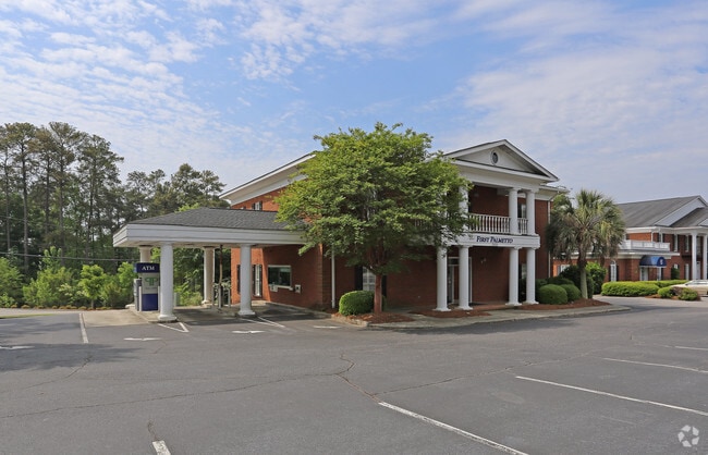
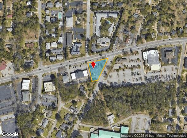
Property Record
3932 Forest Dr, Columbia, SC 29204

NEARBY LISTINGS FOR SALE OR LEASE
Property Detail
3932 Forest Dr
14005-04-06
Forest Acres
Commercialnec
218.9X253.9X61.2X199 #SU FOREST ACRES #PR
X
Richland
45079C0263L
South Carolina
2025
0.72 AC
2024
Forest Acres
011201
Columbia
6,014 SF
Columbia, SC
DEMOGRAPHICS near 3932 Forest Dr
1 Mile
3 Mile
5 Mile
2024 Total Population
8,626
80,377
170,262
2029 Population
8,785
81,798
173,889
Pop Growth 2024-2029
+ 1.84%
+ 1.77%
+ 2.13%
Average Age
42
37
36
2024 Total Households
4,145
33,077
70,353
HH Growth 2024-2029
+ 2.00%
+ 1.93%
+ 2.32%
Median Household Inc
$67,908
$49,737
$45,758
Avg Household Size
2.10
2.10
2.10
2024 Avg HH Vehicles
2.00
2.00
2.00
Median Home Value
$267,808
$249,910
$205,636
Median Year Built
1962
1963
1970
Nearby Places
Map Layers
Map Styles
 Street
 Aerial
- Restaurants
- Banks
- Shops
- Fitness
- Groceries
PUBLIC TRANSPORTATION
COMMUTER RAIL
DRIVE
WALK
Distance
11 min
4.6 mi
AIRPORT
Columbia Metro
DRIVE
WALK
Distance
Columbia Metro
29 min
14.1 mi
Nearby Properties
Address
Land Use
TOTAL SIZE
Lot Size
Zoning
Address
Land Use
TOTAL SIZE
Lot Size
Zoning
501,365 SF
13.28 AC
O-I
Address
Land Use
TOTAL SIZE
Lot Size
Zoning
100 SF
15.17 AC
C-1
Address
Land Use
TOTAL SIZE
Lot Size
Zoning
383,491 SF
2.36 AC
C-3
Address
Land Use
TOTAL SIZE
Lot Size
Zoning
316,116 SF
21.73 AC
RG-2
Address
Land Use
TOTAL SIZE
Lot Size
Zoning
85,065 SF
2.43 AC
C-1
Address
Land Use
TOTAL SIZE
Lot Size
Zoning
100 SF
0.52 AC
C-1
Address
Land Use
TOTAL SIZE
Lot Size
Zoning
13,028 SF
31.69 AC
RG-1
Address
Land Use
TOTAL SIZE
Lot Size
Zoning
100 SF
156.42 AC
RSF-2
Address
Land Use
TOTAL SIZE
Lot Size
Zoning
147,399 SF
2.27 AC
C-1
Address
Land Use
TOTAL SIZE
Lot Size
Zoning
216,180 SF
15.66 AC
C-1
Address
Land Use
TOTAL SIZE
Lot Size
Zoning
231,426 SF
10 AC
C-3
Address
Land Use
TOTAL SIZE
Lot Size
Zoning
167,168 SF
1.37 AC
RG-2
Address
Land Use
TOTAL SIZE
Lot Size
Zoning
100 SF
19.24 AC
C-1
Address
Land Use
TOTAL SIZE
Lot Size
Zoning
14,360 SF
4.61 AC
C-1
Address
Land Use
TOTAL SIZE
Lot Size
Zoning
100 SF
15.68 AC
RG-2
Address
Land Use
TOTAL SIZE
Lot Size
Zoning
169,291 SF
18.97 AC
C-3
Address
Land Use
TOTAL SIZE
Lot Size
Zoning
107,276 SF
2.22 AC
C-4
Address
Land Use
TOTAL SIZE
Lot Size
Zoning
9.66 AC
C-1
Address
Land Use
TOTAL SIZE
Lot Size
Zoning
129,721 SF
3.72 AC
C-3
Address
Land Use
TOTAL SIZE
Lot Size
Zoning
114,450 SF
0.83 AC
C-5
Address
Land Use
TOTAL SIZE
Lot Size
Zoning
259,948 SF
14.40 AC
RM-HD
Address
Land Use
TOTAL SIZE
Lot Size
Zoning
176,000 SF
1.54 AC
C-4
Address
Land Use
TOTAL SIZE
Lot Size
Zoning
202,048 SF
20.98 AC
C-3
Address
Land Use
TOTAL SIZE
Lot Size
Zoning
96,189 SF
2.22 AC
C-1
Address
Land Use
TOTAL SIZE
Lot Size
Zoning
414,262 SF
34.45 AC
RM-HD
Address
Land Use
TOTAL SIZE
Lot Size
Zoning
78,094 SF
2 AC
C-1
Address
Land Use
TOTAL SIZE
Lot Size
Zoning
90,984 SF
2.83 AC
C-1
Address
Land Use
TOTAL SIZE
Lot Size
Zoning
23,379 SF
3.76 AC
M-1
Address
Land Use
TOTAL SIZE
Lot Size
Zoning
115,734 SF
0.98 AC
C-1
Address
Land Use
TOTAL SIZE
Lot Size
Zoning
55.91 AC
M-1
The World's #1 Commercial Real Estate Marketplace
Connect with us
© 2026 CoStar Group
The information above has been obtained from sources believed reliable. While we do not doubt its accuracy we have not verified it and make no guarantee, warranty or representation about it. It is your responsibility to independently confirm its accuracy and completeness. Any projections, opinions, assumptions, or estimates used are for example only and do not represent the current or future performance of the property. The value of this transaction to you depends on tax and other factors which should be evaluated by your tax, financial, and legal advisors. You and your advisors should conduct a careful, independent investigation of the property to determine to your satisfaction the suitability of the property for your needs.