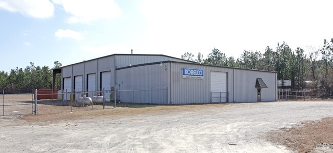
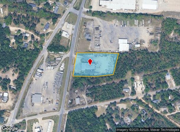
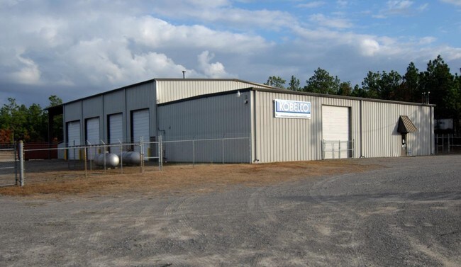
Property Record
3935 Highway 321, West Columbia, SC 29172
NEARBY LISTINGS FOR SALE OR LEASE
Property Detail
3935 Highway 321
Commercialnec
Lexington
X
South Carolina
45063C0289J
2.60 AC
2025
Cayce/West Columbia
2024
Columbia
020706
Columbia, SC
8,060 SF
007999-02-067
DEMOGRAPHICS near 3935 Highway 321
1 Mile
3 Mile
5 Mile
2024 Total Population
925
11,455
26,410
2029 Population
1,031
12,655
29,012
Pop Growth 2024-2029
+ 11.46%
+ 10.48%
+ 9.85%
Average Age
40
38
39
2024 Total Households
369
4,342
10,325
HH Growth 2024-2029
+ 11.65%
+ 10.62%
+ 9.94%
Median Household Inc
$45,869
$53,915
$52,443
Avg Household Size
2.50
2.50
2.50
2024 Avg HH Vehicles
2.00
2.00
2.00
Median Home Value
$138,020
$134,804
$133,002
Median Year Built
1981
1991
1989
Nearby Places
Map Layers
Map Styles
 Street
 Aerial
- Restaurants
- Banks
- Shops
- Fitness
- Groceries
PUBLIC TRANSPORTATION
AIRPORT
Columbia Metro
DRIVE
WALK
Distance
Columbia Metro
20 min
9.0 mi
Nearby Properties
Address
Land Use
TOTAL SIZE
Lot Size
Zoning
Address
Land Use
TOTAL SIZE
Lot Size
Zoning
60.50 AC
Address
Land Use
TOTAL SIZE
Lot Size
Zoning
56.30 AC
Address
Land Use
TOTAL SIZE
Lot Size
Zoning
1,253,820 SF
87.15 AC
Address
Land Use
TOTAL SIZE
Lot Size
Zoning
466,400 SF
52.42 AC
ID
Address
Land Use
TOTAL SIZE
Lot Size
Zoning
186,528 SF
36 AC
Address
Land Use
TOTAL SIZE
Lot Size
Zoning
180,000 SF
27.57 AC
ID
Address
Land Use
TOTAL SIZE
Lot Size
Zoning
181,440 SF
10.69 AC
ID
Address
Land Use
TOTAL SIZE
Lot Size
Zoning
9,800 SF
13.52 AC
ID
Address
Land Use
TOTAL SIZE
Lot Size
Zoning
200,000 SF
10.58 AC
ID
Address
Land Use
TOTAL SIZE
Lot Size
Zoning
200,000 SF
9.66 AC
ID
Address
Land Use
TOTAL SIZE
Lot Size
Zoning
180,000 SF
12.48 AC
ID
Address
Land Use
TOTAL SIZE
Lot Size
Zoning
36.30 AC
Address
Land Use
TOTAL SIZE
Lot Size
Zoning
7.60 AC
Address
Land Use
TOTAL SIZE
Lot Size
Zoning
215,770 SF
24.51 AC
Address
Land Use
TOTAL SIZE
Lot Size
Zoning
50,400 SF
11 AC
ID
Address
Land Use
TOTAL SIZE
Lot Size
Zoning
104,000 SF
18.53 AC
Address
Land Use
TOTAL SIZE
Lot Size
Zoning
120,000 SF
18.44 AC
ID
Address
Land Use
TOTAL SIZE
Lot Size
Zoning
Address
Land Use
TOTAL SIZE
Lot Size
Zoning
50,000 SF
6.89 AC
ID
Address
Land Use
TOTAL SIZE
Lot Size
Zoning
67,824 SF
17.27 AC
ID
Address
Land Use
TOTAL SIZE
Lot Size
Zoning
84.65 AC
Address
Land Use
TOTAL SIZE
Lot Size
Zoning
58.80 AC
Address
Land Use
TOTAL SIZE
Lot Size
Zoning
85,700 SF
20.45 AC
LR
Address
Land Use
TOTAL SIZE
Lot Size
Zoning
104,190 SF
13.37 AC
Address
Land Use
TOTAL SIZE
Lot Size
Zoning
Address
Land Use
TOTAL SIZE
Lot Size
Zoning
88,000 SF
16.30 AC
ID
Address
Land Use
TOTAL SIZE
Lot Size
Zoning
57,730 SF
19.74 AC
ID
Address
Land Use
TOTAL SIZE
Lot Size
Zoning
62.60 AC
Address
Land Use
TOTAL SIZE
Lot Size
Zoning
3,864 SF
20.22 AC
ID
Address
Land Use
TOTAL SIZE
Lot Size
Zoning
61.22 AC
The World's #1 Commercial Real Estate Marketplace
Connect with us
© 2025 CoStar Group
The information above has been obtained from sources believed reliable. While we do not doubt its accuracy we have not verified it and make no guarantee, warranty or representation about it. It is your responsibility to independently confirm its accuracy and completeness. Any projections, opinions, assumptions, or estimates used are for example only and do not represent the current or future performance of the property. The value of this transaction to you depends on tax and other factors which should be evaluated by your tax, financial, and legal advisors. You and your advisors should conduct a careful, independent investigation of the property to determine to your satisfaction the suitability of the property for your needs.