Property Record
3937 Bennington Way, Marengo, OH 43334
NEARBY LISTINGS FOR SALE OR LEASE
-
-
View all Marengo listings for sale on LoopNet.com
Property Detail
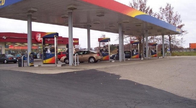
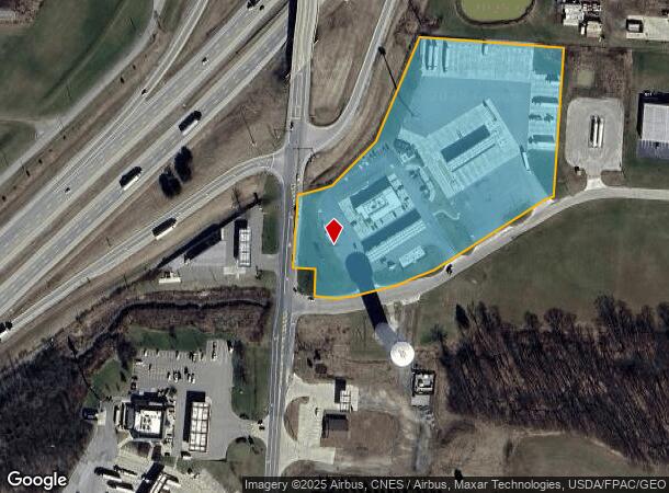
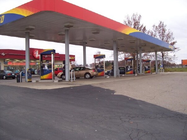
3937 Bennington Way
A01-064-00-005-00
LOT#1 MARENGO SHEETZ SUBD (BENN IND PK) TWP LOT 10 RTS:16-06-3
Servicestation
Morrow
X
Ohio
39083C0275D
1
2024
7.74 AC
2024
Morrow County
965501
Columbus
6,872 SF
Columbus, OH
DEMOGRAPHICS near 3937 Bennington Way
1 Mile
3 Mile
5 Mile
2024 Total Population
413
3,474
8,052
2029 Population
425
3,653
8,562
Pop Growth 2024-2029
+ 2.91%
+ 5.15%
+ 6.33%
Average Age
42
42
42
2024 Total Households
152
1,264
2,923
HH Growth 2024-2029
+ 3.29%
+ 4.98%
+ 6.26%
Median Household Inc
$68,823
$72,944
$74,695
Avg Household Size
2.60
2.70
2.70
2024 Avg HH Vehicles
2.00
2.00
2.00
Median Home Value
$229,807
$264,142
$281,836
Median Year Built
1978
1980
1985
Nearby Places
Map Layers
Map Styles
 Street
 Aerial
- Restaurants
- Banks
- Shops
- Fitness
- Groceries
PUBLIC TRANSPORTATION
AIRPORT
John Glenn Columbus International
DRIVE
WALK
Distance
John Glenn Columbus International
42 min
34.3 mi
Nearby Properties
Address
Land Use
TOTAL SIZE
Lot Size
Zoning
Address
Land Use
TOTAL SIZE
Lot Size
Zoning
1,170,276 SF
Address
Land Use
TOTAL SIZE
Lot Size
Zoning
707,892 SF
35.97 AC
Address
Land Use
TOTAL SIZE
Lot Size
Zoning
62,500 SF
9.58 AC
Address
Land Use
TOTAL SIZE
Lot Size
Zoning
10,944 SF
47 AC
Address
Land Use
TOTAL SIZE
Lot Size
Zoning
2,092 SF
93.73 AC
Address
Land Use
TOTAL SIZE
Lot Size
Zoning
8,768 SF
6.33 AC
Address
Land Use
TOTAL SIZE
Lot Size
Zoning
14,486 SF
2.20 AC
Address
Land Use
TOTAL SIZE
Lot Size
Zoning
35,968 SF
5.84 AC
INDUSTRIAL
Address
Land Use
TOTAL SIZE
Lot Size
Zoning
3,200 SF
50.20 AC
Address
Land Use
TOTAL SIZE
Lot Size
Zoning
4,580 SF
130.11 AC
Address
Land Use
TOTAL SIZE
Lot Size
Zoning
7,906 SF
10 AC
Address
Land Use
TOTAL SIZE
Lot Size
Zoning
9,216 SF
25.30 AC
INDUSTRIAL
Address
Land Use
TOTAL SIZE
Lot Size
Zoning
11,768 SF
79.80 AC
Address
Land Use
TOTAL SIZE
Lot Size
Zoning
1,640 SF
100.61 AC
AGRICULTUR
Address
Land Use
TOTAL SIZE
Lot Size
Zoning
156.58 AC
Address
Land Use
TOTAL SIZE
Lot Size
Zoning
21.84 AC
Address
Land Use
TOTAL SIZE
Lot Size
Zoning
20.04 AC
Address
Land Use
TOTAL SIZE
Lot Size
Zoning
12,464 SF
66.94 AC
Address
Land Use
TOTAL SIZE
Lot Size
Zoning
16,250 SF
4.31 AC
Address
Land Use
TOTAL SIZE
Lot Size
Zoning
6,526 SF
7.05 AC
INDUSTRIAL
Address
Land Use
TOTAL SIZE
Lot Size
Zoning
64.92 AC
Address
Land Use
TOTAL SIZE
Lot Size
Zoning
2,704 SF
5.71 AC
Address
Land Use
TOTAL SIZE
Lot Size
Zoning
3,122 SF
1.26 AC
Address
Land Use
TOTAL SIZE
Lot Size
Zoning
10,658 SF
0.19 AC
Address
Land Use
TOTAL SIZE
Lot Size
Zoning
11,150 SF
61.14 AC
Address
Land Use
TOTAL SIZE
Lot Size
Zoning
74.50 AC
Address
Land Use
TOTAL SIZE
Lot Size
Zoning
9,100 SF
1.72 AC
Address
Land Use
TOTAL SIZE
Lot Size
Zoning
85.30 AC
Address
Land Use
TOTAL SIZE
Lot Size
Zoning
2,654 SF
104.60 AC
The World's #1 Commercial Real Estate Marketplace
Connect with us
© 2026 CoStar Group
The information above has been obtained from sources believed reliable. While we do not doubt its accuracy we have not verified it and make no guarantee, warranty or representation about it. It is your responsibility to independently confirm its accuracy and completeness. Any projections, opinions, assumptions, or estimates used are for example only and do not represent the current or future performance of the property. The value of this transaction to you depends on tax and other factors which should be evaluated by your tax, financial, and legal advisors. You and your advisors should conduct a careful, independent investigation of the property to determine to your satisfaction the suitability of the property for your needs.