Property Record
3939 68Th St Se, Caledonia, MI 49316

NEARBY LISTINGS FOR SALE OR LEASE
-
-
-
-
No Photo
-
View all Caledonia listings for sale on LoopNet.com
Property Detail
3939 68Th St Se
41-22-02-400-012
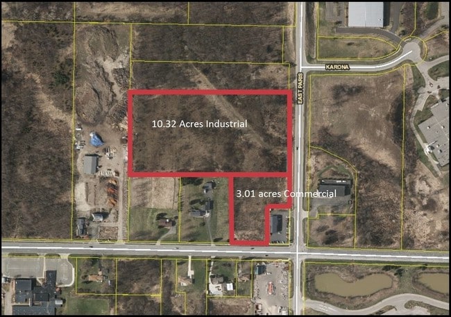
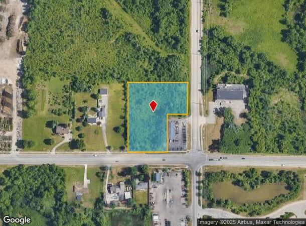
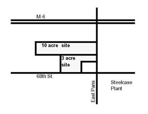
E 3/4 SE 1/4 SE 1/4 EX W 600 FT & EX E 165 FT OF S 264 FT & EX N 880 FT OF REMAINDER * SEC 2 T5N R11W 2.94 A.
Commercialacreage
Kent
X
Michigan
26005C0150G
2.94 AC
2023
SE Kent County/Caledonia
2025
West Michigan
014808
Grand Rapids-Wyoming, MI
DEMOGRAPHICS near 3939 68Th St Se
1 Mile
3 Mile
5 Mile
2024 Total Population
2,406
24,890
95,051
2029 Population
2,445
25,243
96,081
Pop Growth 2024-2029
+ 1.62%
+ 1.42%
+ 1.08%
Average Age
36
38
38
2024 Total Households
946
8,470
36,002
HH Growth 2024-2029
+ 1.69%
+ 1.46%
+ 1.09%
Median Household Inc
$72,094
$93,814
$69,829
Avg Household Size
2.50
2.80
2.50
2024 Avg HH Vehicles
2.00
2.00
2.00
Median Home Value
$228,268
$259,868
$245,062
Median Year Built
1995
1996
1987
Nearby Places
Map Layers
Map Styles
 Street
 Aerial
- Restaurants
- Banks
- Shops
- Fitness
- Groceries
PUBLIC TRANSPORTATION
AIRPORT
Gerald R Ford International
DRIVE
WALK
Distance
Gerald R Ford International
10 min
4.5 mi
Nearby Properties
Address
Land Use
TOTAL SIZE
Lot Size
Zoning
Address
Land Use
TOTAL SIZE
Lot Size
Zoning
719,632 SF
127.88 AC
PUD-PL UNI
Address
Land Use
TOTAL SIZE
Lot Size
Zoning
90.99 AC
Address
Land Use
TOTAL SIZE
Lot Size
Zoning
855,000 SF
PUD LSP-LG
Address
Land Use
TOTAL SIZE
Lot Size
Zoning
24.96 AC
Address
Land Use
TOTAL SIZE
Lot Size
Zoning
Address
Land Use
TOTAL SIZE
Lot Size
Zoning
438,644 SF
117.24 AC
PUD
Address
Land Use
TOTAL SIZE
Lot Size
Zoning
874,605 SF
87.68 AC
I-PUD
Address
Land Use
TOTAL SIZE
Lot Size
Zoning
47.13 AC
PUD
Address
Land Use
TOTAL SIZE
Lot Size
Zoning
155.84 AC
Address
Land Use
TOTAL SIZE
Lot Size
Zoning
223,592 SF
26.33 AC
PUD LSP-LG
Address
Land Use
TOTAL SIZE
Lot Size
Zoning
208.39 AC
I-PUD
Address
Land Use
TOTAL SIZE
Lot Size
Zoning
292,825 SF
15.01 AC
R-PUD-1
Address
Land Use
TOTAL SIZE
Lot Size
Zoning
685,902 SF
38.89 AC
I1
Address
Land Use
TOTAL SIZE
Lot Size
Zoning
266,630 SF
41.30 AC
I1-LIGHT I
Address
Land Use
TOTAL SIZE
Lot Size
Zoning
68.10 AC
Address
Land Use
TOTAL SIZE
Lot Size
Zoning
267,336 SF
13.99 AC
R-PUD-1
Address
Land Use
TOTAL SIZE
Lot Size
Zoning
210,096 SF
75.30 AC
PUD
Address
Land Use
TOTAL SIZE
Lot Size
Zoning
63.52 AC
Address
Land Use
TOTAL SIZE
Lot Size
Zoning
455,880 SF
24.91 AC
I1
Address
Land Use
TOTAL SIZE
Lot Size
Zoning
148.14 AC
Address
Land Use
TOTAL SIZE
Lot Size
Zoning
146.43 AC
Address
Land Use
TOTAL SIZE
Lot Size
Zoning
25.05 AC
R3-MED RES
Address
Land Use
TOTAL SIZE
Lot Size
Zoning
196,764 SF
R1
Address
Land Use
TOTAL SIZE
Lot Size
Zoning
165,589 SF
Address
Land Use
TOTAL SIZE
Lot Size
Zoning
119.44 AC
I-PUD
Address
Land Use
TOTAL SIZE
Lot Size
Zoning
116,480 SF
Address
Land Use
TOTAL SIZE
Lot Size
Zoning
194,254 SF
13.55 AC
I1
Address
Land Use
TOTAL SIZE
Lot Size
Zoning
150,797 SF
11.81 AC
PUD
Address
Land Use
TOTAL SIZE
Lot Size
Zoning
151,788 SF
18.31 AC
PUD-PL UNI
Address
Land Use
TOTAL SIZE
Lot Size
Zoning
245,000 SF
17.43 AC
I1
The World's #1 Commercial Real Estate Marketplace
Connect with us
© 2025 CoStar Group
The information above has been obtained from sources believed reliable. While we do not doubt its accuracy we have not verified it and make no guarantee, warranty or representation about it. It is your responsibility to independently confirm its accuracy and completeness. Any projections, opinions, assumptions, or estimates used are for example only and do not represent the current or future performance of the property. The value of this transaction to you depends on tax and other factors which should be evaluated by your tax, financial, and legal advisors. You and your advisors should conduct a careful, independent investigation of the property to determine to your satisfaction the suitability of the property for your needs.