Property Record
3939 Kell Blvd, Wichita Falls, TX 76308


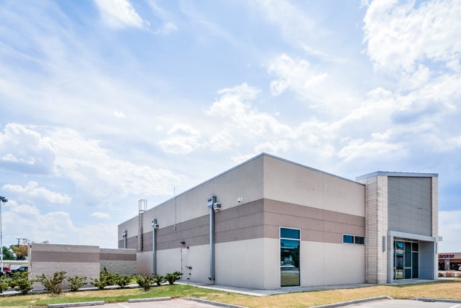
Property Detail
3939 Kell Blvd
461223
LOT 3B BLK 61 FOUNTAIN PARK 4D
Medicalbuilding
Wichita
GC
Texas
B and X Area of moderate flood hazard, usually the area between the limits of the 100-year and 500-year floods.
3b
2024
0.91 AC
2025
Southwest Wichita Falls
012600
Other Market Areas
6,565 SF
Wichita Falls, TX
NEARBY LISTINGS FOR SALE OR LEASE
DEMOGRAPHICS near 3939 Kell Blvd
1 mile
3 mile
5 mile
2025 Total Population
7,924
53,988
84,068
2030 Population
7,798
53,113
83,361
Pop Growth 2025-2030
(1.59%)
(1.62%)
(0.84%)
Average Age
41
39
39
2025 Total Households
3,341
21,952
33,747
HH Growth 2025-2030
(1.77%)
(1.90%)
(1.05%)
Median Household Inc
$72,333
$71,221
$63,297
Avg Household Size
2.30
2.30
2.30
2025 Avg HH Vehicles
2.00
2.00
2.00
Median Home Value
$180,555
$195,400
$175,358
Median Year Built
1967
1970
1970
Nearby Places
Map Layers
Map Styles
 Street
 Aerial
Layers
 Traffic
 Biking
Places
Listings with unknown addresses are not visible on the map
- Restaurants
- Banks
- Shops
- Fitness
- Groceries
SALE & LEASE HISTORY
LISTING DATE
SALE/LEASE

Oct 20, 2016
For Sale
Mar 26, 2018
For Lease
Mar 26, 2018
For Sale
Nearby Properties
Address
Land Use
TOTAL SIZE
Lot Size
Zoning
Address
Land Use
TOTAL SIZE
Lot Size
Zoning
1,172,641 SF
100 AC
Address
Land Use
TOTAL SIZE
Lot Size
Zoning
394,440 SF
104.37 AC
GC
Address
Land Use
TOTAL SIZE
Lot Size
Zoning
45,719 SF
35.31 AC
Address
Land Use
TOTAL SIZE
Lot Size
Zoning
358,158 SF
150.40 AC
Address
Land Use
TOTAL SIZE
Lot Size
Zoning
588,693 SF
271.40 AC
Address
Land Use
TOTAL SIZE
Lot Size
Zoning
245,000 SF
37 AC
SF2
Address
Land Use
TOTAL SIZE
Lot Size
Zoning
275,676 SF
22.58 AC
Address
Land Use
TOTAL SIZE
Lot Size
Zoning
247,406 SF
10 AC
Address
Land Use
TOTAL SIZE
Lot Size
Zoning
157,968 SF
7.40 AC
GC
Address
Land Use
TOTAL SIZE
Lot Size
Zoning
129,655 SF
Address
Land Use
TOTAL SIZE
Lot Size
Zoning
266,509 SF
14.25 AC
SF2
Address
Land Use
TOTAL SIZE
Lot Size
Zoning
200,421 SF
18.57 AC
MFR
Address
Land Use
TOTAL SIZE
Lot Size
Zoning
130,756 SF
14.82 AC
Address
Land Use
TOTAL SIZE
Lot Size
Zoning
9.60 AC
LI
Address
Land Use
TOTAL SIZE
Lot Size
Zoning
138,336 SF
18.97 AC
GC
Address
Land Use
TOTAL SIZE
Lot Size
Zoning
158,687 SF
14.68 AC
GC
Address
Land Use
TOTAL SIZE
Lot Size
Zoning
62,791 SF
63.60 AC
Address
Land Use
TOTAL SIZE
Lot Size
Zoning
784,240 SF
58.86 AC
GC
Address
Land Use
TOTAL SIZE
Lot Size
Zoning
151,854 SF
5.11 AC
Address
Land Use
TOTAL SIZE
Lot Size
Zoning
189,192 SF
9.24 AC
GC
Address
Land Use
TOTAL SIZE
Lot Size
Zoning
78,105 SF
6.66 AC
Address
Land Use
TOTAL SIZE
Lot Size
Zoning
67,381 SF
4.25 AC
GC
Address
Land Use
TOTAL SIZE
Lot Size
Zoning
226,866 SF
12.10 AC
MFR
Address
Land Use
TOTAL SIZE
Lot Size
Zoning
69,483 SF
30 AC
Address
Land Use
TOTAL SIZE
Lot Size
Zoning
224,276 SF
23 AC
Address
Land Use
TOTAL SIZE
Lot Size
Zoning
82,761 SF
2.01 AC
GC
Address
Land Use
TOTAL SIZE
Lot Size
Zoning
70,217 SF
9.63 AC
Address
Land Use
TOTAL SIZE
Lot Size
Zoning
62,292 SF
14.61 AC
Address
Land Use
TOTAL SIZE
Lot Size
Zoning
179,865 SF
11.46 AC
Address
Land Use
TOTAL SIZE
Lot Size
Zoning
89,546 SF
4.74 AC
The World's #1 Commercial Real Estate Marketplace
Connect with us
© 2026 CoStar Group
The information above has been obtained from sources believed reliable. While we do not doubt its accuracy we have not verified it and make no guarantee, warranty or representation about it. It is your responsibility to independently confirm its accuracy and completeness. Any projections, opinions, assumptions, or estimates used are for example only and do not represent the current or future performance of the property. The value of this transaction to you depends on tax and other factors which should be evaluated by your tax, financial, and legal advisors. You and your advisors should conduct a careful, independent investigation of the property to determine to your satisfaction the suitability of the property for your needs.