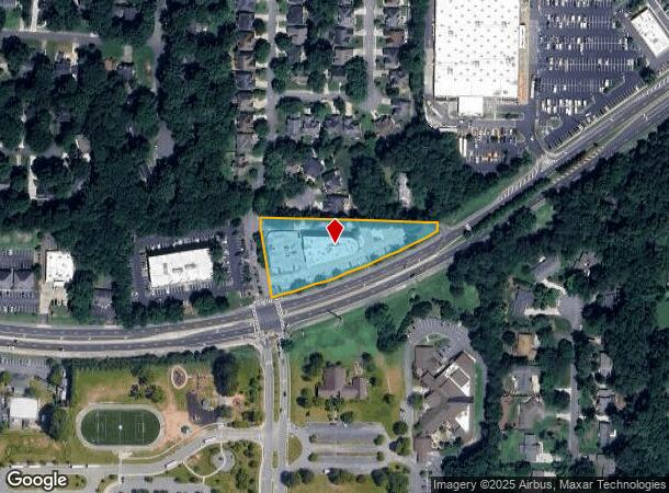
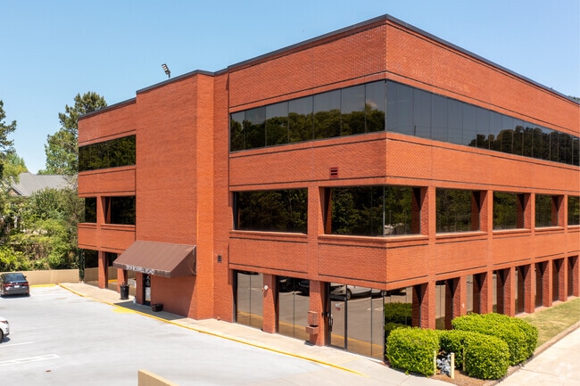
Property Record
3939 Roswell Rd, Marietta, GA 30062


Current Lease Availabilities
NEARBY LISTINGS FOR SALE OR LEASE
Property Detail
3939 Roswell Rd
Atlanta-Sandy Springs-Roswell, GA
Bragg Wood & Assoc Inc
16-0969-0-001-0
ALL THAT TRACT OR PARCEL OF LAND LYING AND BEING IN THE 16TH DISTRICT, 2ND SECTION, COBB COUNTY, GEORGIA, LYING WITHIN LAND LOT 0969, IDENTIFIED AS TAX PARCEL 001, ON THE FIELD
Medicalbuilding
Cobb
X
Georgia
13067C0131G
969
2025
1.59 AC
2025
East Cobb
030332
Atlanta
57,742 SF
DEMOGRAPHICS near 3939 Roswell Rd
1 Mile
3 Mile
5 Mile
2024 Total Population
7,007
65,982
198,793
2029 Population
7,063
66,435
201,326
Pop Growth 2024-2029
+ 0.80%
+ 0.69%
+ 1.27%
Average Age
42
42
40
2024 Total Households
2,387
22,655
77,061
HH Growth 2024-2029
+ 0.75%
+ 0.66%
+ 1.28%
Median Household Inc
$138,760
$157,890
$109,893
Avg Household Size
2.90
2.90
2.50
2024 Avg HH Vehicles
2.00
2.00
2.00
Median Home Value
$483,078
$514,616
$462,291
Median Year Built
1980
1982
1983
Nearby Places
Map Layers
Map Styles
 Street
 Aerial
- Restaurants
- Banks
- Shops
- Fitness
- Groceries
PUBLIC TRANSPORTATION
AIRPORT
Hartsfield - Jackson Atlanta International
DRIVE
WALK
Distance
Hartsfield - Jackson Atlanta International
45 min
31.0 mi
Freight Ports
Georgia Ports - Savannah
DRIVE
WALK
Distance
Georgia Ports - Savannah
308 min
270.3 mi
Nearby Properties
Address
Land Use
TOTAL SIZE
Lot Size
Zoning
Address
Land Use
TOTAL SIZE
Lot Size
Zoning
258,955 SF
29.70 AC
CRC/LRO
Address
Land Use
TOTAL SIZE
Lot Size
Zoning
3,406 SF
23.20 AC
R20
Address
Land Use
TOTAL SIZE
Lot Size
Zoning
166,048 SF
20.29 AC
GC
Address
Land Use
TOTAL SIZE
Lot Size
Zoning
194,453 SF
17.71 AC
CRC/WS
Address
Land Use
TOTAL SIZE
Lot Size
Zoning
152,191 SF
9.63 AC
RSL
Address
Land Use
TOTAL SIZE
Lot Size
Zoning
119,776 SF
11.17 AC
NS/WS
Address
Land Use
TOTAL SIZE
Lot Size
Zoning
92,787 SF
11.69 AC
CRC/NS
Address
Land Use
TOTAL SIZE
Lot Size
Zoning
182,506 SF
8.49 AC
RSL
Address
Land Use
TOTAL SIZE
Lot Size
Zoning
106,968 SF
0.77 AC
PSC
Address
Land Use
TOTAL SIZE
Lot Size
Zoning
1,576 SF
3.24 AC
RSL
Address
Land Use
TOTAL SIZE
Lot Size
Zoning
84,299 SF
13.83 AC
GC
Address
Land Use
TOTAL SIZE
Lot Size
Zoning
67,397 SF
7.59 AC
NS
Address
Land Use
TOTAL SIZE
Lot Size
Zoning
117,668 SF
12.17 AC
PSC
Address
Land Use
TOTAL SIZE
Lot Size
Zoning
78,103 SF
8.54 AC
CRC/WS
Address
Land Use
TOTAL SIZE
Lot Size
Zoning
84,473 SF
13.06 AC
NRC
Address
Land Use
TOTAL SIZE
Lot Size
Zoning
64,015 SF
4.37 AC
CRC/WS
Address
Land Use
TOTAL SIZE
Lot Size
Zoning
239,207 SF
8.78 AC
GC/WS
Address
Land Use
TOTAL SIZE
Lot Size
Zoning
44,346 SF
4.46 AC
CRC
Address
Land Use
TOTAL SIZE
Lot Size
Zoning
72,399 SF
12.18 AC
R-30
Address
Land Use
TOTAL SIZE
Lot Size
Zoning
93,007 SF
11.65 AC
NRC/WS
Address
Land Use
TOTAL SIZE
Lot Size
Zoning
128,491 SF
9.09 AC
OI
Address
Land Use
TOTAL SIZE
Lot Size
Zoning
59,632 SF
2.40 AC
OI
Address
Land Use
TOTAL SIZE
Lot Size
Zoning
33,808 SF
5.31 AC
PSC
Address
Land Use
TOTAL SIZE
Lot Size
Zoning
59,494 SF
1.96 AC
O&I/WS
Address
Land Use
TOTAL SIZE
Lot Size
Zoning
12.10 AC
Address
Land Use
TOTAL SIZE
Lot Size
Zoning
87,132 SF
7.10 AC
PSC
Address
Land Use
TOTAL SIZE
Lot Size
Zoning
98,580 SF
1.28 AC
GC
Address
Land Use
TOTAL SIZE
Lot Size
Zoning
48,189 SF
5.87 AC
PSC
Address
Land Use
TOTAL SIZE
Lot Size
Zoning
50,537 SF
3.73 AC
OI
Address
Land Use
TOTAL SIZE
Lot Size
Zoning
58,901 SF
2.30 AC
GC/WS
The World's #1 Commercial Real Estate Marketplace
Connect with us
© 2026 CoStar Group
The information above has been obtained from sources believed reliable. While we do not doubt its accuracy we have not verified it and make no guarantee, warranty or representation about it. It is your responsibility to independently confirm its accuracy and completeness. Any projections, opinions, assumptions, or estimates used are for example only and do not represent the current or future performance of the property. The value of this transaction to you depends on tax and other factors which should be evaluated by your tax, financial, and legal advisors. You and your advisors should conduct a careful, independent investigation of the property to determine to your satisfaction the suitability of the property for your needs.