Property Record
39390 Interstate 10 W, Boerne, TX 78006
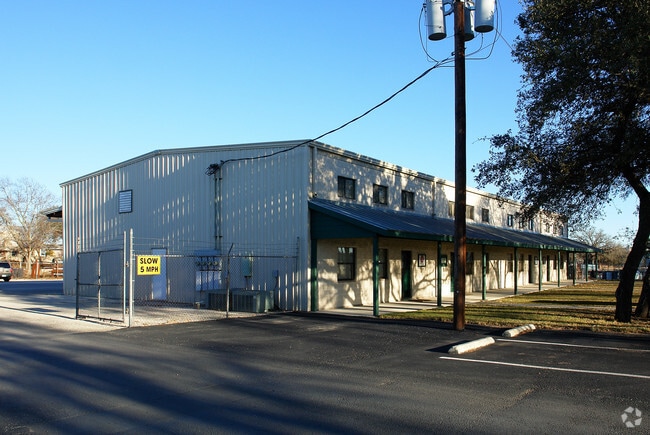

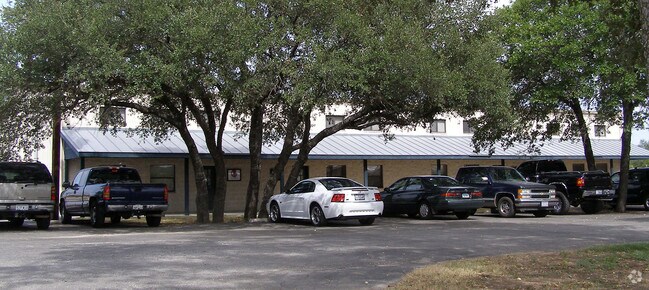
Property Detail
39390 Interstate 10 W
12949
A10166 - SURVEY 174 N FLORES 6.872 ACRES
Commercialbuilding
KENDALL
B and X Area of moderate flood hazard, usually the area between the limits of the 100-year and 500-year floods.
Texas
2024
6.87 AC
2025
Kendall County
970301
San Antonio
37,882 SF
San Antonio-New Braunfels, TX
NEARBY LISTINGS FOR SALE OR LEASE
DEMOGRAPHICS near 39390 Interstate 10 W
1 mile
3 mile
5 mile
2025 Total Population
1,088
13,815
29,020
2030 Population
1,223
15,509
32,722
Pop Growth 2025-2030
+ 12.41%
+ 12.26%
+ 12.76%
Average Age
47
43
42
2025 Total Households
424
5,391
10,831
HH Growth 2025-2030
+ 12.50%
+ 12.35%
+ 12.88%
Median Household Inc
$109,375
$86,201
$96,347
Avg Household Size
2.60
2.50
2.60
2025 Avg HH Vehicles
2.00
2.00
2.00
Median Home Value
$497,457
$466,177
$488,127
Median Year Built
1994
2000
2001
Nearby Places
Map Layers
Map Styles
 Street
 Aerial
Transit
 Traffic
 Biking
Places
Listings with unknown addresses are not visible on the map
- Restaurants
- Banks
- Shops
- Fitness
- Groceries
PUBLIC TRANSPORTATION
AIRPORT
San Antonio International
Drive
Walk
Distance
San Antonio International
38 min
32.1 mi
Freight Ports
Calhoun Port
Drive
Walk
Distance
Calhoun Port
217 min
183.7 mi
Nearby Properties
Address
Land Use
TOTAL SIZE
Lot Size
Zoning
Address
Land Use
TOTAL SIZE
Lot Size
Zoning
135,904 SF
10.40 AC
Address
Land Use
TOTAL SIZE
Lot Size
Zoning
86,050 SF
25.59 AC
Address
Land Use
TOTAL SIZE
Lot Size
Zoning
78,586 SF
15.36 AC
Address
Land Use
TOTAL SIZE
Lot Size
Zoning
111,517 SF
20.86 AC
Address
Land Use
TOTAL SIZE
Lot Size
Zoning
90,958 SF
19.64 AC
Address
Land Use
TOTAL SIZE
Lot Size
Zoning
83,845 SF
7.32 AC
Address
Land Use
TOTAL SIZE
Lot Size
Zoning
4,080 SF
302.27 AC
Address
Land Use
TOTAL SIZE
Lot Size
Zoning
185,555 SF
11.76 AC
Address
Land Use
TOTAL SIZE
Lot Size
Zoning
43,470 SF
1.77 AC
Address
Land Use
TOTAL SIZE
Lot Size
Zoning
1,924 SF
103.24 AC
Address
Land Use
TOTAL SIZE
Lot Size
Zoning
86,137 SF
Address
Land Use
TOTAL SIZE
Lot Size
Zoning
128,730 SF
Address
Land Use
TOTAL SIZE
Lot Size
Zoning
49,307 SF
1.07 AC
Address
Land Use
TOTAL SIZE
Lot Size
Zoning
29,732 SF
2.85 AC
Address
Land Use
TOTAL SIZE
Lot Size
Zoning
48,975 SF
2.98 AC
Address
Land Use
TOTAL SIZE
Lot Size
Zoning
89,570 SF
4.82 AC
Address
Land Use
TOTAL SIZE
Lot Size
Zoning
26,100 SF
1.17 AC
Address
Land Use
TOTAL SIZE
Lot Size
Zoning
103,625 SF
4.88 AC
Address
Land Use
TOTAL SIZE
Lot Size
Zoning
139,865 SF
21.97 AC
Address
Land Use
TOTAL SIZE
Lot Size
Zoning
43,452 SF
3.32 AC
Address
Land Use
TOTAL SIZE
Lot Size
Zoning
90,229 SF
13.38 AC
Address
Land Use
TOTAL SIZE
Lot Size
Zoning
31,678 SF
30 AC
Address
Land Use
TOTAL SIZE
Lot Size
Zoning
68,889 SF
2.17 AC
Address
Land Use
TOTAL SIZE
Lot Size
Zoning
44,943 SF
11.58 AC
Address
Land Use
TOTAL SIZE
Lot Size
Zoning
14,144 SF
12.25 AC
Address
Land Use
TOTAL SIZE
Lot Size
Zoning
38,323 SF
3 AC
Address
Land Use
TOTAL SIZE
Lot Size
Zoning
91,270 SF
6.74 AC
Address
Land Use
TOTAL SIZE
Lot Size
Zoning
17,579 SF
0.96 AC
Address
Land Use
TOTAL SIZE
Lot Size
Zoning
22,716 SF
2.98 AC
Address
Land Use
TOTAL SIZE
Lot Size
Zoning
37,386 SF
1.54 AC
The World's #1 Commercial Real Estate Marketplace
Connect with us
© 2026 CoStar Group
The information above has been obtained from sources believed reliable. While we do not doubt its accuracy we have not verified it and make no guarantee, warranty or representation about it. It is your responsibility to independently confirm its accuracy and completeness. Any projections, opinions, assumptions, or estimates used are for example only and do not represent the current or future performance of the property. The value of this transaction to you depends on tax and other factors which should be evaluated by your tax, financial, and legal advisors. You and your advisors should conduct a careful, independent investigation of the property to determine to your satisfaction the suitability of the property for your needs.