Property Record
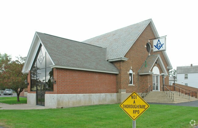
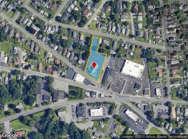
394 Princetown Rd, Schenectady, NY 12306
NEARBY LISTINGS FOR SALE OR LEASE
-
-
View all Schenectady listings for sale on LoopNet.com
Property Detail
394 Princetown Rd
048-019-0005-012-000-0000
Schenectady
Charitableorganization
New York
X
12.000
36093C0161D
1.03 AC
2025
Outer Schenectady County
2024
Albany/Schenectady/Troy
032700
Albany-Schenectady-Troy, NY
4,320 SF
DEMOGRAPHICS near 394 Princetown Rd
1 Mile
3 Mile
5 Mile
2024 Total Population
12,444
65,831
130,303
2029 Population
13,111
69,134
136,579
Pop Growth 2024-2029
+ 5.36%
+ 5.02%
+ 4.82%
Average Age
40
39
40
2024 Total Households
5,381
27,657
54,302
HH Growth 2024-2029
+ 5.74%
+ 5.31%
+ 5.11%
Median Household Inc
$71,131
$60,729
$68,540
Avg Household Size
2.30
2.30
2.30
2024 Avg HH Vehicles
2.00
1.00
2.00
Median Home Value
$157,326
$164,124
$175,502
Median Year Built
1949
1949
1952
Nearby Places
Map Layers
Map Styles
 Street
 Aerial
- Restaurants
- Banks
- Shops
- Fitness
- Groceries
PUBLIC TRANSPORTATION
COMMUTER RAIL
DRIVE
WALK
Distance
8 min
3.0 mi
AIRPORT
Albany International
DRIVE
WALK
Distance
Albany International
24 min
12.2 mi
Freight Ports
Albany, NY Port
DRIVE
WALK
Distance
Albany, NY Port
30 min
18.5 mi
Nearby Properties
Address
Land Use
TOTAL SIZE
Lot Size
Zoning
Address
Land Use
TOTAL SIZE
Lot Size
Zoning
2,068,862 SF
204.52 AC
I-2
Address
Land Use
TOTAL SIZE
Lot Size
Zoning
0.01 AC
06 - INDUS
Address
Land Use
TOTAL SIZE
Lot Size
Zoning
1,003,413 SF
177.60 AC
B-1, I-1
Address
Land Use
TOTAL SIZE
Lot Size
Zoning
382,858 SF
70.33 AC
R-1
Address
Land Use
TOTAL SIZE
Lot Size
Zoning
59,240 SF
0.72 AC
05 - COMME
Address
Land Use
TOTAL SIZE
Lot Size
Zoning
284,171 SF
16.40 AC
03 - MULTI
Address
Land Use
TOTAL SIZE
Lot Size
Zoning
183,759 SF
1.40 AC
05 - COMME
Address
Land Use
TOTAL SIZE
Lot Size
Zoning
181,230 SF
1.02 AC
05 - COMME
Address
Land Use
TOTAL SIZE
Lot Size
Zoning
4,896 SF
12.80 AC
A-1
Address
Land Use
TOTAL SIZE
Lot Size
Zoning
128,744 SF
119 AC
A-1
Address
Land Use
TOTAL SIZE
Lot Size
Zoning
9.38 AC
I-2
Address
Land Use
TOTAL SIZE
Lot Size
Zoning
152,503 SF
8.21 AC
I-1
Address
Land Use
TOTAL SIZE
Lot Size
Zoning
136,722 SF
2.01 AC
05 - COMME
Address
Land Use
TOTAL SIZE
Lot Size
Zoning
21,791 SF
4.93 AC
B-1, B-2
Address
Land Use
TOTAL SIZE
Lot Size
Zoning
141,145 SF
1.11 AC
05 - COMME
Address
Land Use
TOTAL SIZE
Lot Size
Zoning
21,791 SF
4.86 AC
B-1, B-2
Address
Land Use
TOTAL SIZE
Lot Size
Zoning
Address
Land Use
TOTAL SIZE
Lot Size
Zoning
12,289 SF
17.08 AC
R-3
Address
Land Use
TOTAL SIZE
Lot Size
Zoning
113,670 SF
1.35 AC
05 - COMME
Address
Land Use
TOTAL SIZE
Lot Size
Zoning
202,050 SF
20.75 AC
B-2
Address
Land Use
TOTAL SIZE
Lot Size
Zoning
116,392 SF
1.84 AC
05 - COMME
Address
Land Use
TOTAL SIZE
Lot Size
Zoning
99.20 AC
Address
Land Use
TOTAL SIZE
Lot Size
Zoning
229,890 SF
85.08 AC
I-1
Address
Land Use
TOTAL SIZE
Lot Size
Zoning
127,632 SF
3.50 AC
B-1
Address
Land Use
TOTAL SIZE
Lot Size
Zoning
161,606 SF
1.14 AC
05 - COMME
Address
Land Use
TOTAL SIZE
Lot Size
Zoning
59,030 SF
1.27 AC
05 - COMME
Address
Land Use
TOTAL SIZE
Lot Size
Zoning
115,660 SF
12.37 AC
B-1
Address
Land Use
TOTAL SIZE
Lot Size
Zoning
230,000 SF
12.99 AC
I-1
Address
Land Use
TOTAL SIZE
Lot Size
Zoning
78,240 SF
10.55 AC
B-2
Address
Land Use
TOTAL SIZE
Lot Size
Zoning
10,212 SF
7.09 AC
B-2
The World's #1 Commercial Real Estate Marketplace
Connect with us
© 2026 CoStar Group
The information above has been obtained from sources believed reliable. While we do not doubt its accuracy we have not verified it and make no guarantee, warranty or representation about it. It is your responsibility to independently confirm its accuracy and completeness. Any projections, opinions, assumptions, or estimates used are for example only and do not represent the current or future performance of the property. The value of this transaction to you depends on tax and other factors which should be evaluated by your tax, financial, and legal advisors. You and your advisors should conduct a careful, independent investigation of the property to determine to your satisfaction the suitability of the property for your needs.