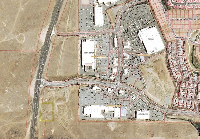
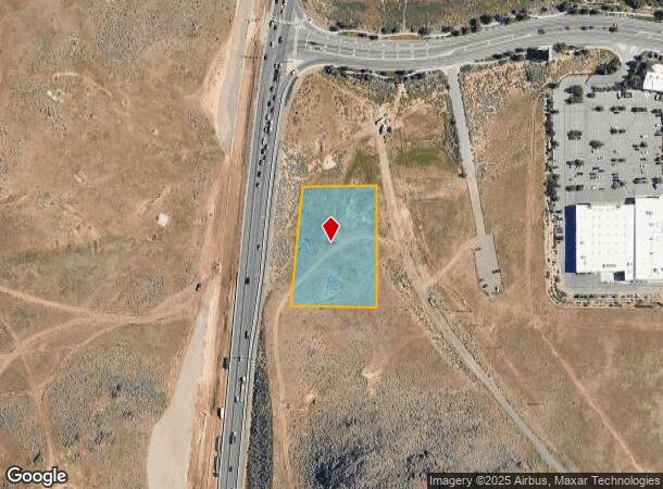
Property Record
3940 Pyramid Way, Sparks, NV 89436

NEARBY LISTINGS FOR SALE OR LEASE
Property Detail
3940 Pyramid Way
Reno, NV
_Unspecified
035-183-01
FR NE4 NW4 SEC 28 TWP 20 RGE 20
Residentialacreage
Washoe
X
Nevada
32031C3053G
1.88 AC
2025
Sparks
2026
Reno/Sparks
003512
DEMOGRAPHICS near 3940 Pyramid Way
1 Mile
3 Mile
5 Mile
2024 Total Population
4,086
114,214
189,314
2029 Population
4,288
120,407
199,434
Pop Growth 2024-2029
+ 4.94%
+ 5.42%
+ 5.35%
Average Age
41
39
38
2024 Total Households
1,529
43,288
71,311
HH Growth 2024-2029
+ 5.17%
+ 5.73%
+ 5.59%
Median Household Inc
$84,710
$66,319
$65,767
Avg Household Size
2.60
2.60
2.50
2024 Avg HH Vehicles
2.00
2.00
2.00
Median Home Value
$415,905
$368,383
$388,699
Median Year Built
1997
1987
1989
Nearby Places
Map Layers
Map Styles
 Street
 Aerial
- Restaurants
- Banks
- Shops
- Fitness
- Groceries
PUBLIC TRANSPORTATION
COMMUTER RAIL
Reno (California Zephyr - Amtrak)
DRIVE
WALK
Distance
Reno (California Zephyr - Amtrak)
11 min
6.6 mi
AIRPORT
Reno/Tahoe International
DRIVE
WALK
Distance
Reno/Tahoe International
29 min
10.4 mi
Freight Ports
Port of Stockton
DRIVE
WALK
Distance
Port of Stockton
214 min
184.7 mi
SALE & LEASE HISTORY
LISTING DATE
SALE/LEASE

Sep 24, 2016
For Sale
Aug 20, 2024
For Sale
Aug 07, 2021
For Sale
Nearby Properties
Address
Land Use
TOTAL SIZE
Lot Size
Zoning
Address
Land Use
TOTAL SIZE
Lot Size
Zoning
294,872 SF
69.02 AC
PF
Address
Land Use
TOTAL SIZE
Lot Size
Zoning
406,338 SF
15.07 AC
NUD
Address
Land Use
TOTAL SIZE
Lot Size
Zoning
333,867 SF
14.71 AC
NUD
Address
Land Use
TOTAL SIZE
Lot Size
Zoning
271,111 SF
31.84 AC
NUD
Address
Land Use
TOTAL SIZE
Lot Size
Zoning
356,160 SF
12.05 AC
MUD
Address
Land Use
TOTAL SIZE
Lot Size
Zoning
347,564 SF
10.23 AC
MUD
Address
Land Use
TOTAL SIZE
Lot Size
Zoning
321,941 SF
36 AC
NUD
Address
Land Use
TOTAL SIZE
Lot Size
Zoning
365,962 SF
3.54 AC
PD
Address
Land Use
TOTAL SIZE
Lot Size
Zoning
600 SF
279.66 AC
ME 61% / P
Address
Land Use
TOTAL SIZE
Lot Size
Zoning
617,081 SF
2.62 AC
MUD
Address
Land Use
TOTAL SIZE
Lot Size
Zoning
279,596 SF
10.94 AC
NUD
Address
Land Use
TOTAL SIZE
Lot Size
Zoning
246,076 SF
16.43 AC
PD
Address
Land Use
TOTAL SIZE
Lot Size
Zoning
622,628 SF
2.91 AC
MUD
Address
Land Use
TOTAL SIZE
Lot Size
Zoning
232,481 SF
9.45 AC
PD
Address
Land Use
TOTAL SIZE
Lot Size
Zoning
248,124 SF
19.35 AC
PD
Address
Land Use
TOTAL SIZE
Lot Size
Zoning
273,101 SF
15.96 AC
MF-3/PUD
Address
Land Use
TOTAL SIZE
Lot Size
Zoning
237,680 SF
16.65 AC
PD
Address
Land Use
TOTAL SIZE
Lot Size
Zoning
258,793 SF
14.86 AC
MF-3
Address
Land Use
TOTAL SIZE
Lot Size
Zoning
203,367 SF
1 AC
MUD
Address
Land Use
TOTAL SIZE
Lot Size
Zoning
173,178 SF
8.15 AC
MUD
Address
Land Use
TOTAL SIZE
Lot Size
Zoning
396,497 SF
20.80 AC
PD
Address
Land Use
TOTAL SIZE
Lot Size
Zoning
166,637 SF
6.46 AC
MF30
Address
Land Use
TOTAL SIZE
Lot Size
Zoning
136,331 SF
0.93 AC
MUD
Address
Land Use
TOTAL SIZE
Lot Size
Zoning
203,303 SF
20.97 AC
C2
Address
Land Use
TOTAL SIZE
Lot Size
Zoning
201,361 SF
15.63 AC
MF21
Address
Land Use
TOTAL SIZE
Lot Size
Zoning
146,255 SF
9.99 AC
MDU
Address
Land Use
TOTAL SIZE
Lot Size
Zoning
221,512 SF
15.32 AC
MUD
Address
Land Use
TOTAL SIZE
Lot Size
Zoning
74,637 SF
6.04 AC
NUD
Address
Land Use
TOTAL SIZE
Lot Size
Zoning
148,346 SF
15.79 AC
NUD
Address
Land Use
TOTAL SIZE
Lot Size
Zoning
125,167 SF
18.10 AC
GC
The World's #1 Commercial Real Estate Marketplace
Connect with us
© 2025 CoStar Group
The information above has been obtained from sources believed reliable. While we do not doubt its accuracy we have not verified it and make no guarantee, warranty or representation about it. It is your responsibility to independently confirm its accuracy and completeness. Any projections, opinions, assumptions, or estimates used are for example only and do not represent the current or future performance of the property. The value of this transaction to you depends on tax and other factors which should be evaluated by your tax, financial, and legal advisors. You and your advisors should conduct a careful, independent investigation of the property to determine to your satisfaction the suitability of the property for your needs.