Property Record
3941 Chestnut St, Emmaus, PA 18049
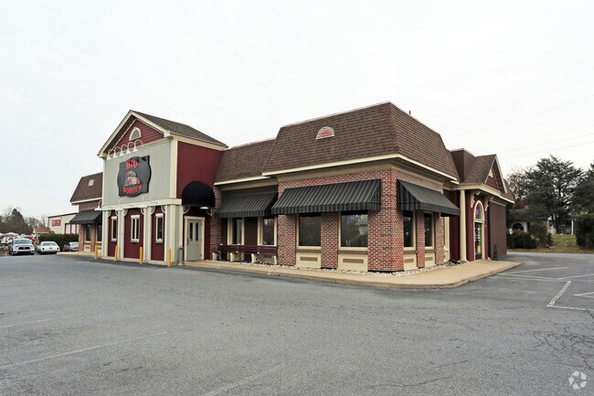
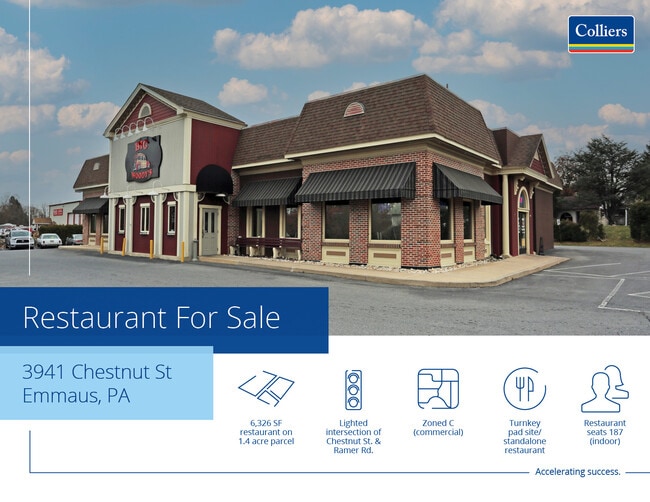
This Property Is For Sale
NEARBY LISTINGS FOR SALE OR LEASE
Property Detail
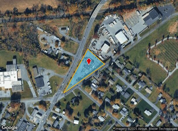
3941 Chestnut St
Allentown-Bethlehem-Easton, PA-NJ
Minor Subdivision
548480782229-1
LOTS: 001
Restaurantbuilding
Lehigh
X
Pennsylvania
42011C0250G
1
2025
1.40 AC
2025
Lehigh Valley
006401
Philadelphia
6,101 SF
DEMOGRAPHICS near 3941 Chestnut St
1 Mile
3 Mile
5 Mile
2024 Total Population
4,873
38,364
98,296
2029 Population
4,925
38,520
98,903
Pop Growth 2024-2029
+ 1.07%
+ 0.41%
+ 0.62%
Average Age
44
43
42
2024 Total Households
2,092
15,736
38,653
HH Growth 2024-2029
+ 1.05%
+ 0.35%
+ 0.58%
Median Household Inc
$83,525
$89,707
$84,571
Avg Household Size
2.30
2.40
2.50
2024 Avg HH Vehicles
2.00
2.00
2.00
Median Home Value
$297,860
$292,165
$284,890
Median Year Built
1978
1980
1976
Nearby Places
Map Layers
Map Styles
 Street
 Aerial
- Restaurants
- Banks
- Shops
- Fitness
- Groceries
PUBLIC TRANSPORTATION
AIRPORT
Lehigh Valley International
DRIVE
WALK
Distance
Lehigh Valley International
25 min
12.8 mi
Freight Ports
Port of Philadelphia
DRIVE
WALK
Distance
Port of Philadelphia
86 min
57.6 mi
Nearby Properties
Address
Land Use
TOTAL SIZE
Lot Size
Zoning
Address
Land Use
TOTAL SIZE
Lot Size
Zoning
413,834 SF
40 AC
R-L
Address
Land Use
TOTAL SIZE
Lot Size
Zoning
199,343 SF
48.68 AC
O
Address
Land Use
TOTAL SIZE
Lot Size
Zoning
7,132 SF
21.72 AC
C
Address
Land Use
TOTAL SIZE
Lot Size
Zoning
32,500 SF
147.04 AC
I
Address
Land Use
TOTAL SIZE
Lot Size
Zoning
44,302 SF
17.25 AC
I-L
Address
Land Use
TOTAL SIZE
Lot Size
Zoning
85,585 SF
24.47 AC
SR
Address
Land Use
TOTAL SIZE
Lot Size
Zoning
84,564 SF
20.53 AC
R1
Address
Land Use
TOTAL SIZE
Lot Size
Zoning
12,688 SF
13.47 AC
R4
Address
Land Use
TOTAL SIZE
Lot Size
Zoning
39,485 SF
8.16 AC
C3
Address
Land Use
TOTAL SIZE
Lot Size
Zoning
15,472 SF
10.40 AC
R-7.
Address
Land Use
TOTAL SIZE
Lot Size
Zoning
1,922 SF
44.40 AC
I
Address
Land Use
TOTAL SIZE
Lot Size
Zoning
14,330 SF
11.32 AC
R-M
Address
Land Use
TOTAL SIZE
Lot Size
Zoning
2,866 SF
12.21 AC
R-M
Address
Land Use
TOTAL SIZE
Lot Size
Zoning
13,160 SF
6.90 AC
R-L
Address
Land Use
TOTAL SIZE
Lot Size
Zoning
19,124 SF
14.03 AC
R-P
Address
Land Use
TOTAL SIZE
Lot Size
Zoning
22,380 SF
13.79 AC
R-P
Address
Land Use
TOTAL SIZE
Lot Size
Zoning
43,702 SF
1.98 AC
R-HO
Address
Land Use
TOTAL SIZE
Lot Size
Zoning
29,620 SF
5.78 AC
C3
Address
Land Use
TOTAL SIZE
Lot Size
Zoning
60,141 SF
0.76 AC
R-HO
Address
Land Use
TOTAL SIZE
Lot Size
Zoning
70,230 SF
13.07 AC
C
Address
Land Use
TOTAL SIZE
Lot Size
Zoning
101,411 SF
3.84 AC
C1
Address
Land Use
TOTAL SIZE
Lot Size
Zoning
12,948 SF
5.72 AC
B-H
Address
Land Use
TOTAL SIZE
Lot Size
Zoning
6,725 SF
6.13 AC
R-7.
Address
Land Use
TOTAL SIZE
Lot Size
Zoning
40.21 AC
S
Address
Land Use
TOTAL SIZE
Lot Size
Zoning
66,305 SF
21.95 AC
C3
Address
Land Use
TOTAL SIZE
Lot Size
Zoning
7,548 SF
4.94 AC
R-L
Address
Land Use
TOTAL SIZE
Lot Size
Zoning
40,436 SF
3.33 AC
C2
Address
Land Use
TOTAL SIZE
Lot Size
Zoning
29,496 SF
22.56 AC
O
Address
Land Use
TOTAL SIZE
Lot Size
Zoning
30,051 SF
4.68 AC
C
Address
Land Use
TOTAL SIZE
Lot Size
Zoning
224,173 SF
16.56 AC
M
The World's #1 Commercial Real Estate Marketplace
Connect with us
© 2026 CoStar Group
The information above has been obtained from sources believed reliable. While we do not doubt its accuracy we have not verified it and make no guarantee, warranty or representation about it. It is your responsibility to independently confirm its accuracy and completeness. Any projections, opinions, assumptions, or estimates used are for example only and do not represent the current or future performance of the property. The value of this transaction to you depends on tax and other factors which should be evaluated by your tax, financial, and legal advisors. You and your advisors should conduct a careful, independent investigation of the property to determine to your satisfaction the suitability of the property for your needs.