Property Record
3901 J St, Sacramento, CA 95819


This Property Is For Sale
NEARBY LISTINGS FOR SALE OR LEASE
Property Detail
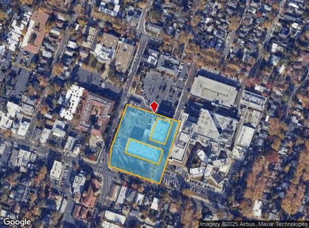
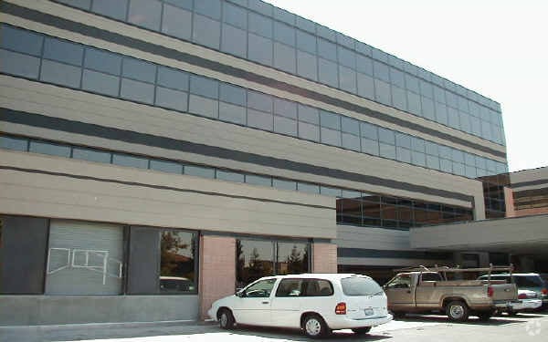
3901 J St
Sacramento--Roseville--Arden-Arcade, CA
Parcel Map Of Mercy General Hospital Pha
008-0510-003
PARCEL MAP OF MERCY GENERAL HOSPITAL PHASE 2, LOT 3
Officebuilding
Sacramento
X
California
06067C0180J
3
2024
2.36 AC
2025
East Sacramento
001601
Sacramento
DEMOGRAPHICS near 3901 J St
1 Mile
3 Mile
5 Mile
2024 Total Population
20,721
169,774
443,357
2029 Population
20,991
172,071
447,988
Pop Growth 2024-2029
+ 1.30%
+ 1.35%
+ 1.04%
Average Age
43
39
38
2024 Total Households
9,757
75,408
172,386
HH Growth 2024-2029
+ 1.32%
+ 1.55%
+ 1.16%
Median Household Inc
$120,285
$69,296
$65,380
Avg Household Size
2.00
2.00
2.40
2024 Avg HH Vehicles
2.00
1.00
2.00
Median Home Value
$768,414
$593,529
$455,055
Median Year Built
1947
1961
1966
Nearby Places
Map Layers
Map Styles
 Street
 Aerial
- Restaurants
- Banks
- Shops
- Fitness
- Groceries
PUBLIC TRANSPORTATION
TRANSIT/SUBWAY
39Th Street (Gold Line - Sacramento Regional Transit District Light Rail (The RT))
DRIVE
WALK
Distance
39Th Street (Gold Line - Sacramento Regional Transit District Light Rail (The RT))
3 min
16 min
0.8 mi
COMMUTER RAIL
Sacramento (Capitol Corridor - Capitol Corridor Joint Powers Authority)
DRIVE
WALK
Distance
Sacramento (Capitol Corridor - Capitol Corridor Joint Powers Authority)
7 min
3.2 mi
AIRPORT
Sacramento International
DRIVE
WALK
Distance
Sacramento International
22 min
13.9 mi
Freight Ports
Port of Stockton
DRIVE
WALK
Distance
Port of Stockton
58 min
49.3 mi
Nearby Properties
Address
Land Use
TOTAL SIZE
Lot Size
Zoning
Address
Land Use
TOTAL SIZE
Lot Size
Zoning
1,095,507 SF
1.39 AC
H-SPD C-2-
Address
Land Use
TOTAL SIZE
Lot Size
Zoning
5.64 AC
C-3-SPD
Address
Land Use
TOTAL SIZE
Lot Size
Zoning
10.28 AC
H
Address
Land Use
TOTAL SIZE
Lot Size
Zoning
299,943 SF
4.95 AC
H
Address
Land Use
TOTAL SIZE
Lot Size
Zoning
201,132 SF
28.11 AC
C-2
Address
Land Use
TOTAL SIZE
Lot Size
Zoning
487,483 SF
1.12 AC
C-3-SPD
Address
Land Use
TOTAL SIZE
Lot Size
Zoning
1.33 AC
R-1
Address
Land Use
TOTAL SIZE
Lot Size
Zoning
756,831 SF
1.39 AC
C-2-SPD
Address
Land Use
TOTAL SIZE
Lot Size
Zoning
9.29 AC
R-1 OB-R-P
Address
Land Use
TOTAL SIZE
Lot Size
Zoning
399,626 SF
2.41 AC
C-3-SPD
Address
Land Use
TOTAL SIZE
Lot Size
Zoning
1.15 AC
R-1
Address
Land Use
TOTAL SIZE
Lot Size
Zoning
490,607 SF
32.63 AC
RD-30
Address
Land Use
TOTAL SIZE
Lot Size
Zoning
366,730 SF
0.89 AC
C-3-SPD
Address
Land Use
TOTAL SIZE
Lot Size
Zoning
200,616 SF
2.54 AC
C-2-SPD
Address
Land Use
TOTAL SIZE
Lot Size
Zoning
2.87 AC
C-2
Address
Land Use
TOTAL SIZE
Lot Size
Zoning
594,942 SF
2.39 AC
C-3-SPD
Address
Land Use
TOTAL SIZE
Lot Size
Zoning
31,163 SF
1.57 AC
C-2-TO-SPD
Address
Land Use
TOTAL SIZE
Lot Size
Zoning
10.49 AC
C-2
Address
Land Use
TOTAL SIZE
Lot Size
Zoning
350,049 SF
8.51 AC
MRD-SWR
Address
Land Use
TOTAL SIZE
Lot Size
Zoning
676,447 SF
1.43 AC
C-3-SPD
Address
Land Use
TOTAL SIZE
Lot Size
Zoning
319,856 SF
12.27 AC
R-3-R-PUD
Address
Land Use
TOTAL SIZE
Lot Size
Zoning
193,521 SF
0.60 AC
C-3-SPD
Address
Land Use
TOTAL SIZE
Lot Size
Zoning
339,329 SF
6.40 AC
R-5-PUD-SP
Address
Land Use
TOTAL SIZE
Lot Size
Zoning
213,557 SF
2.33 AC
C-3-SPD
Address
Land Use
TOTAL SIZE
Lot Size
Zoning
226,731 SF
15.73 AC
OB-PUD
Address
Land Use
TOTAL SIZE
Lot Size
Zoning
281,448 SF
13.42 AC
RMX-TO R-2
Address
Land Use
TOTAL SIZE
Lot Size
Zoning
0.65 AC
C-4-SPD
Address
Land Use
TOTAL SIZE
Lot Size
Zoning
390,860 SF
20.17 AC
R-3-R-PUD
Address
Land Use
TOTAL SIZE
Lot Size
Zoning
410,420 SF
0.95 AC
C-3-SPD
Address
Land Use
TOTAL SIZE
Lot Size
Zoning
320,072 SF
2.65 AC
C-2
The World's #1 Commercial Real Estate Marketplace
Connect with us
© 2025 CoStar Group
The information above has been obtained from sources believed reliable. While we do not doubt its accuracy we have not verified it and make no guarantee, warranty or representation about it. It is your responsibility to independently confirm its accuracy and completeness. Any projections, opinions, assumptions, or estimates used are for example only and do not represent the current or future performance of the property. The value of this transaction to you depends on tax and other factors which should be evaluated by your tax, financial, and legal advisors. You and your advisors should conduct a careful, independent investigation of the property to determine to your satisfaction the suitability of the property for your needs.