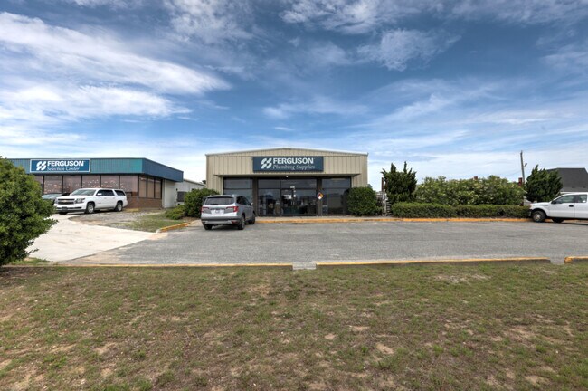
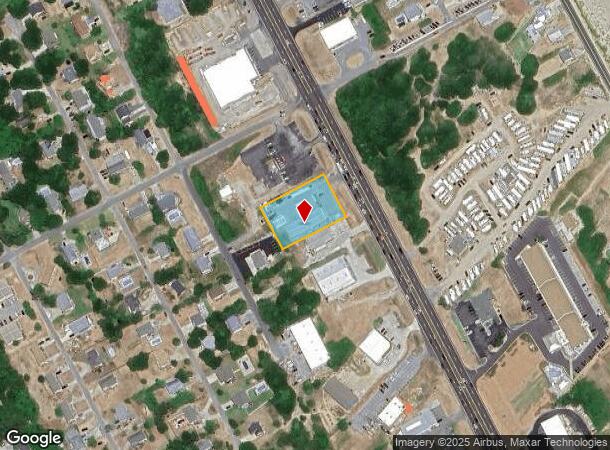
Property Record
3942 N Croatan Hwy, Kitty Hawk, NC 27949

NEARBY LISTINGS FOR SALE OR LEASE
-
-
View all Kitty Hawk listings for sale on LoopNet.com
Property Detail
3942 N Croatan Hwy
Kill Devil Hills, NC
Ted Wood Kitty Hawk Terr Add
018080001
LOT: 1 & PT OF 2 BLK: A SEC: PL: 5 SL: 46
Storebuilding
Dare
X
North Carolina
3720987600K
1
2025
0.78 AC
2025
Coastal Carolina
970101
Other Market Areas
5,000 SF
DEMOGRAPHICS near 3942 N Croatan Hwy
1 Mile
3 Mile
5 Mile
2024 Total Population
2,025
9,174
19,848
2029 Population
2,212
10,075
21,708
Pop Growth 2024-2029
+ 9.23%
+ 9.82%
+ 9.37%
Average Age
45
45
45
2024 Total Households
870
4,034
8,519
HH Growth 2024-2029
+ 8.97%
+ 9.64%
+ 9.24%
Median Household Inc
$76,774
$72,808
$77,164
Avg Household Size
2.30
2.30
2.30
2024 Avg HH Vehicles
2.00
2.00
2.00
Median Home Value
$394,036
$361,626
$365,211
Median Year Built
1987
1984
1986
Nearby Places
Map Layers
Map Styles
 Street
 Aerial
- Restaurants
- Banks
- Shops
- Fitness
- Groceries
SALE & LEASE HISTORY
LISTING DATE
SALE/LEASE

Jun 14, 2021
For Sale
Nearby Properties
Address
Land Use
TOTAL SIZE
Lot Size
Zoning
Address
Land Use
TOTAL SIZE
Lot Size
Zoning
117,130 SF
6.46 AC
Address
Land Use
TOTAL SIZE
Lot Size
Zoning
100,504 SF
14.07 AC
Address
Land Use
TOTAL SIZE
Lot Size
Zoning
57,902 SF
18.12 AC
Address
Land Use
TOTAL SIZE
Lot Size
Zoning
16,485 SF
21.40 AC
Address
Land Use
TOTAL SIZE
Lot Size
Zoning
127,914 SF
18.25 AC
Address
Land Use
TOTAL SIZE
Lot Size
Zoning
120,394 SF
12.02 AC
Address
Land Use
TOTAL SIZE
Lot Size
Zoning
108,315 SF
12.55 AC
Address
Land Use
TOTAL SIZE
Lot Size
Zoning
460.62 AC
Address
Land Use
TOTAL SIZE
Lot Size
Zoning
40,576 SF
3.71 AC
Address
Land Use
TOTAL SIZE
Lot Size
Zoning
14,360 SF
8.19 AC
Address
Land Use
TOTAL SIZE
Lot Size
Zoning
4,788 SF
10.13 AC
Address
Land Use
TOTAL SIZE
Lot Size
Zoning
119,104 SF
0.14 AC
Address
Land Use
TOTAL SIZE
Lot Size
Zoning
12,480 SF
8.59 AC
Address
Land Use
TOTAL SIZE
Lot Size
Zoning
34,416 SF
7.74 AC
Address
Land Use
TOTAL SIZE
Lot Size
Zoning
24,878 SF
8.26 AC
Address
Land Use
TOTAL SIZE
Lot Size
Zoning
Address
Land Use
TOTAL SIZE
Lot Size
Zoning
18,514 SF
1.55 AC
Address
Land Use
TOTAL SIZE
Lot Size
Zoning
30,400 SF
4.48 AC
Address
Land Use
TOTAL SIZE
Lot Size
Zoning
107.25 AC
Address
Land Use
TOTAL SIZE
Lot Size
Zoning
8,954 SF
5.97 AC
Address
Land Use
TOTAL SIZE
Lot Size
Zoning
30,704 SF
1.10 AC
Address
Land Use
TOTAL SIZE
Lot Size
Zoning
7,000 SF
4.05 AC
Address
Land Use
TOTAL SIZE
Lot Size
Zoning
13,649 SF
6.93 AC
Address
Land Use
TOTAL SIZE
Lot Size
Zoning
9,594 SF
1.61 AC
Address
Land Use
TOTAL SIZE
Lot Size
Zoning
56,716 SF
1.72 AC
Address
Land Use
TOTAL SIZE
Lot Size
Zoning
16,644 SF
4.25 AC
Address
Land Use
TOTAL SIZE
Lot Size
Zoning
25,222 SF
4.86 AC
Address
Land Use
TOTAL SIZE
Lot Size
Zoning
5,980 SF
2.32 AC
Address
Land Use
TOTAL SIZE
Lot Size
Zoning
16,848 SF
1.18 AC
Address
Land Use
TOTAL SIZE
Lot Size
Zoning
23,748 SF
5.12 AC
The World's #1 Commercial Real Estate Marketplace
Connect with us
© 2025 CoStar Group
The information above has been obtained from sources believed reliable. While we do not doubt its accuracy we have not verified it and make no guarantee, warranty or representation about it. It is your responsibility to independently confirm its accuracy and completeness. Any projections, opinions, assumptions, or estimates used are for example only and do not represent the current or future performance of the property. The value of this transaction to you depends on tax and other factors which should be evaluated by your tax, financial, and legal advisors. You and your advisors should conduct a careful, independent investigation of the property to determine to your satisfaction the suitability of the property for your needs.