Property Record
3943 E Main St, Russellville, AR 72802
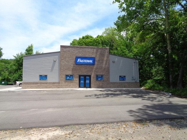

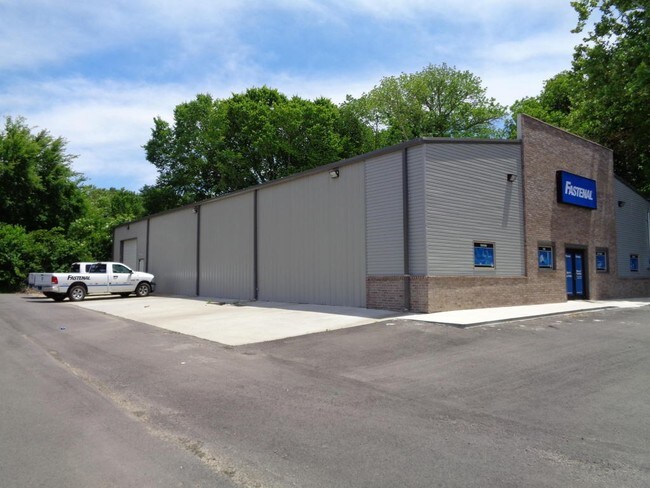
Property Detail
3943 E Main St
858-30018-001C
PT SW NE 12 7 20 CITY OF RUSSELLVILLE
Storebuilding
Pope
B and X Area of moderate flood hazard, usually the area between the limits of the 100-year and 500-year floods.
Arkansas
2024
1.16 AC
2025
Fort Smith/Russellville I-40
951202
Other Market Areas
6,000 SF
Russellville, AR
NEARBY LISTINGS FOR SALE OR LEASE
DEMOGRAPHICS near 3943 E Main St
1 mile
3 mile
5 mile
2025 Total Population
1,291
13,272
33,151
2030 Population
1,310
13,384
33,610
Pop Growth 2025-2030
+ 1.47%
+ 0.84%
+ 1.38%
Average Age
38
37
37
2025 Total Households
455
5,139
12,692
HH Growth 2025-2030
+ 1.32%
+ 0.84%
+ 1.47%
Median Household Inc
$79,587
$56,749
$52,748
Avg Household Size
2.70
2.50
2.40
2025 Avg HH Vehicles
2.00
2.00
2.00
Median Home Value
$216,667
$176,300
$181,369
Median Year Built
1989
1987
1985
Nearby Places
Map Layers
Map Styles
 Street
 Aerial
Layers
 Traffic
 Biking
Places
Listings with unknown addresses are not visible on the map
- Restaurants
- Banks
- Shops
- Fitness
- Groceries
SALE & LEASE HISTORY
LISTING DATE
SALE/LEASE

Jun 28, 2017
For Sale
Jun 23, 2017
For Sale
Aug 25, 2017
For Sale
Aug 21, 2017
For Sale
Aug 04, 2017
For Sale
Nearby Properties
Address
Land Use
TOTAL SIZE
Lot Size
Zoning
Address
Land Use
TOTAL SIZE
Lot Size
Zoning
95,305 SF
17.27 AC
Address
Land Use
TOTAL SIZE
Lot Size
Zoning
807,059 SF
53.70 AC
Address
Land Use
TOTAL SIZE
Lot Size
Zoning
189,756 SF
18.30 AC
Address
Land Use
TOTAL SIZE
Lot Size
Zoning
61,652 SF
20 AC
Address
Land Use
TOTAL SIZE
Lot Size
Zoning
221,457 SF
22.28 AC
Address
Land Use
TOTAL SIZE
Lot Size
Zoning
277,687 SF
28.83 AC
Address
Land Use
TOTAL SIZE
Lot Size
Zoning
293,355 SF
94.01 AC
Address
Land Use
TOTAL SIZE
Lot Size
Zoning
68,660 SF
17.63 AC
Address
Land Use
TOTAL SIZE
Lot Size
Zoning
250,834 SF
25.20 AC
Address
Land Use
TOTAL SIZE
Lot Size
Zoning
194,164 SF
55.75 AC
Address
Land Use
TOTAL SIZE
Lot Size
Zoning
113,308 SF
18.02 AC
Address
Land Use
TOTAL SIZE
Lot Size
Zoning
12,078 SF
22.32 AC
Address
Land Use
TOTAL SIZE
Lot Size
Zoning
327,436 SF
29 AC
Address
Land Use
TOTAL SIZE
Lot Size
Zoning
81,844 SF
7.30 AC
Address
Land Use
TOTAL SIZE
Lot Size
Zoning
133,229 SF
40 AC
Address
Land Use
TOTAL SIZE
Lot Size
Zoning
226,225 SF
27.89 AC
Address
Land Use
TOTAL SIZE
Lot Size
Zoning
195,016 SF
12.91 AC
Address
Land Use
TOTAL SIZE
Lot Size
Zoning
245,532 SF
25.93 AC
Address
Land Use
TOTAL SIZE
Lot Size
Zoning
64,974 SF
7.33 AC
Address
Land Use
TOTAL SIZE
Lot Size
Zoning
12,315 SF
7.50 AC
Address
Land Use
TOTAL SIZE
Lot Size
Zoning
287,866 SF
39 AC
Address
Land Use
TOTAL SIZE
Lot Size
Zoning
15,482 SF
11.49 AC
Address
Land Use
TOTAL SIZE
Lot Size
Zoning
59,719 SF
6.25 AC
Address
Land Use
TOTAL SIZE
Lot Size
Zoning
40,937 SF
5.07 AC
Address
Land Use
TOTAL SIZE
Lot Size
Zoning
39,050 SF
17.66 AC
Address
Land Use
TOTAL SIZE
Lot Size
Zoning
149,932 SF
16.38 AC
Address
Land Use
TOTAL SIZE
Lot Size
Zoning
22,974 SF
4.15 AC
Address
Land Use
TOTAL SIZE
Lot Size
Zoning
96,399 SF
6.89 AC
Address
Land Use
TOTAL SIZE
Lot Size
Zoning
71,568 SF
10.07 AC
Address
Land Use
TOTAL SIZE
Lot Size
Zoning
35,102 SF
4.07 AC
The World's #1 Commercial Real Estate Marketplace
Connect with us
© 2026 CoStar Group
The information above has been obtained from sources believed reliable. While we do not doubt its accuracy we have not verified it and make no guarantee, warranty or representation about it. It is your responsibility to independently confirm its accuracy and completeness. Any projections, opinions, assumptions, or estimates used are for example only and do not represent the current or future performance of the property. The value of this transaction to you depends on tax and other factors which should be evaluated by your tax, financial, and legal advisors. You and your advisors should conduct a careful, independent investigation of the property to determine to your satisfaction the suitability of the property for your needs.