Property Record
3943 S 76Th St, Milwaukee, WI 53220


NEARBY LISTINGS FOR SALE OR LEASE
-
-
View all Milwaukee listings for sale on LoopNet.com
Property Detail
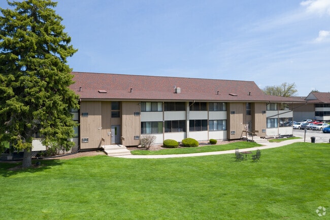
3943 S 76Th St
Milwaukee-Waukesha-West Allis, WI
Howard Terrace Addn
570-9994-114-8
LANDS IN NE 1/4 SEC 21-6-21 COM E LI & 479.41 S OF NE COR SD 1/4 SEC-TH S 359.27-TH W 195-TH S 264-TH W 5-TH S 59.94 TO N LI HOWARD TERRACE ADDN NO 1-TH W 235.26 TO E LI OF WOODLAWN COURTS NO 2-TH N 247.13-TH W 59.69-TH N TO N LI SD 1/4 SEC-TH E 164.
Apartment
Milwaukee
X
Wisconsin
55133C0375G
7.37 AC
2024
Woodland Court
2024
Milwaukee/Madison
019700
DEMOGRAPHICS near 3943 S 76Th St
1 Mile
3 Mile
5 Mile
2024 Total Population
17,368
124,099
325,908
2029 Population
16,887
120,994
319,362
Pop Growth 2024-2029
(2.77%)
(2.50%)
(2.01%)
Average Age
42
41
40
2024 Total Households
7,894
55,056
133,556
HH Growth 2024-2029
(2.84%)
(2.56%)
(2.01%)
Median Household Inc
$63,239
$66,076
$63,393
Avg Household Size
2.20
2.20
2.40
2024 Avg HH Vehicles
2.00
2.00
2.00
Median Home Value
$193,755
$197,576
$206,248
Median Year Built
1964
1960
1958
Nearby Places
Map Layers
Map Styles
 Street
 Aerial
- Restaurants
- Banks
- Shops
- Fitness
- Groceries
PUBLIC TRANSPORTATION
COMMUTER RAIL
General Mitchell Intl. Airport Amtrak Station (Hiawatha Service - Amtrak)
DRIVE
WALK
Distance
General Mitchell Intl. Airport Amtrak Station (Hiawatha Service - Amtrak)
15 min
6.9 mi
AIRPORT
General Mitchell International
DRIVE
WALK
Distance
General Mitchell International
15 min
7.0 mi
Freight Ports
Port Milwaukee
DRIVE
WALK
Distance
Port Milwaukee
14 min
9.0 mi
Nearby Properties
Address
Land Use
TOTAL SIZE
Lot Size
Zoning
Address
Land Use
TOTAL SIZE
Lot Size
Zoning
4.07 AC
Address
Land Use
TOTAL SIZE
Lot Size
Zoning
19.92 AC
Address
Land Use
TOTAL SIZE
Lot Size
Zoning
6.74 AC
Address
Land Use
TOTAL SIZE
Lot Size
Zoning
20.36 AC
Address
Land Use
TOTAL SIZE
Lot Size
Zoning
8.70 AC
Address
Land Use
TOTAL SIZE
Lot Size
Zoning
8,881 SF
7.52 AC
Address
Land Use
TOTAL SIZE
Lot Size
Zoning
13.39 AC
Address
Land Use
TOTAL SIZE
Lot Size
Zoning
23.09 AC
Address
Land Use
TOTAL SIZE
Lot Size
Zoning
18.79 AC
Address
Land Use
TOTAL SIZE
Lot Size
Zoning
188,328 SF
22.41 AC
PD
Address
Land Use
TOTAL SIZE
Lot Size
Zoning
17.47 AC
R2
Address
Land Use
TOTAL SIZE
Lot Size
Zoning
Address
Land Use
TOTAL SIZE
Lot Size
Zoning
16.84 AC
Address
Land Use
TOTAL SIZE
Lot Size
Zoning
262,150 SF
14.62 AC
PUDR5
Address
Land Use
TOTAL SIZE
Lot Size
Zoning
Address
Land Use
TOTAL SIZE
Lot Size
Zoning
238,201 SF
17.96 AC
PUDR5
Address
Land Use
TOTAL SIZE
Lot Size
Zoning
228,912 SF
16.77 AC
Address
Land Use
TOTAL SIZE
Lot Size
Zoning
Address
Land Use
TOTAL SIZE
Lot Size
Zoning
20.61 AC
TL
Address
Land Use
TOTAL SIZE
Lot Size
Zoning
213,840 SF
13.95 AC
PUDR5
Address
Land Use
TOTAL SIZE
Lot Size
Zoning
4.27 AC
Address
Land Use
TOTAL SIZE
Lot Size
Zoning
11.33 AC
Address
Land Use
TOTAL SIZE
Lot Size
Zoning
5.31 AC
Address
Land Use
TOTAL SIZE
Lot Size
Zoning
229,921 SF
8.07 AC
PUD
Address
Land Use
TOTAL SIZE
Lot Size
Zoning
156,753 SF
12.28 AC
LB1
Address
Land Use
TOTAL SIZE
Lot Size
Zoning
Address
Land Use
TOTAL SIZE
Lot Size
Zoning
Address
Land Use
TOTAL SIZE
Lot Size
Zoning
Address
Land Use
TOTAL SIZE
Lot Size
Zoning
4.16 AC
The World's #1 Commercial Real Estate Marketplace
Connect with us
© 2025 CoStar Group
The information above has been obtained from sources believed reliable. While we do not doubt its accuracy we have not verified it and make no guarantee, warranty or representation about it. It is your responsibility to independently confirm its accuracy and completeness. Any projections, opinions, assumptions, or estimates used are for example only and do not represent the current or future performance of the property. The value of this transaction to you depends on tax and other factors which should be evaluated by your tax, financial, and legal advisors. You and your advisors should conduct a careful, independent investigation of the property to determine to your satisfaction the suitability of the property for your needs.