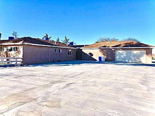
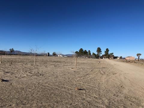
Property Record
39441 140Th St E, Palmdale, CA 93591

Property Detail
39441 140Th St E
3079-003-012
40 MORE OR LESS ACS SE 1/4 OF NE 1/4 OF SEC 24 T 6N R 10W
Privateschool
Los Angeles
LCA21*
California
A Areas with a 1% annual chance of flooding and a 26% chance of flooding over the life of a 30-year mortgage.
24
2024
41.16 AC
2025
NE LA County Outlying
911100
Los Angeles
4,224 SF
Los Angeles-Long Beach-Glendale, CA
NEARBY LISTINGS FOR SALE OR LEASE
DEMOGRAPHICS near 39441 140Th St E
1 mile
3 mile
5 mile
2025 Total Population
20
5,060
20,244
2030 Population
20
4,987
20,176
Pop Growth 2025-2030
0.00%
(1.44%)
(0.34%)
Average Age
36
37
37
2025 Total Households
6
1,416
5,407
HH Growth 2025-2030
(16.67%)
(1.77%)
(0.57%)
Median Household Inc
$67,500
$62,002
$65,185
Avg Household Size
3.00
3.40
3.50
2025 Avg HH Vehicles
3.00
2.00
2.00
Median Home Value
$299,999
$252,986
$307,498
Median Year Built
1982
1982
1982
Nearby Places
Map Layers
Map Styles
 Street
 Aerial
Layers
 Traffic
 Biking
Places
Listings with unknown addresses are not visible on the map
- Restaurants
- Banks
- Shops
- Fitness
- Groceries
SALE & LEASE HISTORY
LISTING DATE
SALE/LEASE

Feb 04, 2020
For Sale
Nearby Properties
Address
Land Use
TOTAL SIZE
Lot Size
Zoning
Address
Land Use
TOTAL SIZE
Lot Size
Zoning
24.67 AC
PDA2*
Address
Land Use
TOTAL SIZE
Lot Size
Zoning
159.10 AC
LCA25*
Address
Land Use
TOTAL SIZE
Lot Size
Zoning
77.74 AC
LCA25*
Address
Land Use
TOTAL SIZE
Lot Size
Zoning
80.23 AC
LCA25*
Address
Land Use
TOTAL SIZE
Lot Size
Zoning
9.49 AC
LCRA40000*
Address
Land Use
TOTAL SIZE
Lot Size
Zoning
168 AC
LCA12*
Address
Land Use
TOTAL SIZE
Lot Size
Zoning
79.96 AC
LCA11*
Address
Land Use
TOTAL SIZE
Lot Size
Zoning
163.01 AC
LCA21*
Address
Land Use
TOTAL SIZE
Lot Size
Zoning
5,196 SF
2.23 AC
LCA21*
Address
Land Use
TOTAL SIZE
Lot Size
Zoning
37.76 AC
LCA25*
Address
Land Use
TOTAL SIZE
Lot Size
Zoning
92.77 AC
LCA25*
Address
Land Use
TOTAL SIZE
Lot Size
Zoning
39.22 AC
PDA1*
Address
Land Use
TOTAL SIZE
Lot Size
Zoning
35.70 AC
PDA2*
Address
Land Use
TOTAL SIZE
Lot Size
Zoning
80.47 AC
LCA25*
Address
Land Use
TOTAL SIZE
Lot Size
Zoning
98.86 AC
LCA12*
Address
Land Use
TOTAL SIZE
Lot Size
Zoning
40.22 AC
LCA11*
Address
Land Use
TOTAL SIZE
Lot Size
Zoning
323.24 AC
LCA21*
Address
Land Use
TOTAL SIZE
Lot Size
Zoning
2,304 SF
27.86 AC
LCA25*
Address
Land Use
TOTAL SIZE
Lot Size
Zoning
110.82 AC
LCA1
Address
Land Use
TOTAL SIZE
Lot Size
Zoning
82.30 AC
LCA11*
Address
Land Use
TOTAL SIZE
Lot Size
Zoning
2,689 SF
79.86 AC
PDA2*
Address
Land Use
TOTAL SIZE
Lot Size
Zoning
30.51 AC
LCA21*
Address
Land Use
TOTAL SIZE
Lot Size
Zoning
13.18 AC
LCA11*
Address
Land Use
TOTAL SIZE
Lot Size
Zoning
36.20 AC
LCA25*
Address
Land Use
TOTAL SIZE
Lot Size
Zoning
79.97 AC
LCA12*
Address
Land Use
TOTAL SIZE
Lot Size
Zoning
41.32 AC
LCA25*
Address
Land Use
TOTAL SIZE
Lot Size
Zoning
13.33 AC
LCA25*
Address
Land Use
TOTAL SIZE
Lot Size
Zoning
3.91 AC
LCA11*
Address
Land Use
TOTAL SIZE
Lot Size
Zoning
78.66 AC
PDA2*
The World's #1 Commercial Real Estate Marketplace
Connect with us
© 2026 CoStar Group
The information above has been obtained from sources believed reliable. While we do not doubt its accuracy we have not verified it and make no guarantee, warranty or representation about it. It is your responsibility to independently confirm its accuracy and completeness. Any projections, opinions, assumptions, or estimates used are for example only and do not represent the current or future performance of the property. The value of this transaction to you depends on tax and other factors which should be evaluated by your tax, financial, and legal advisors. You and your advisors should conduct a careful, independent investigation of the property to determine to your satisfaction the suitability of the property for your needs.